
RFID in Revolutionizing Asset Tracking Across Industries
A recent article highlighting the 25 Technologies that have changed the world lists the usual blockbuster inventions, such as the Apple iPhone, Wi-Fi, AI, facial recognition, drones, DNA testing, social platforms, quantum computing and bitcoin. However, not all of these world-changing technologies are so famous. Who knew that Radio Frequency Identification (RFID) is a world-changing technology?
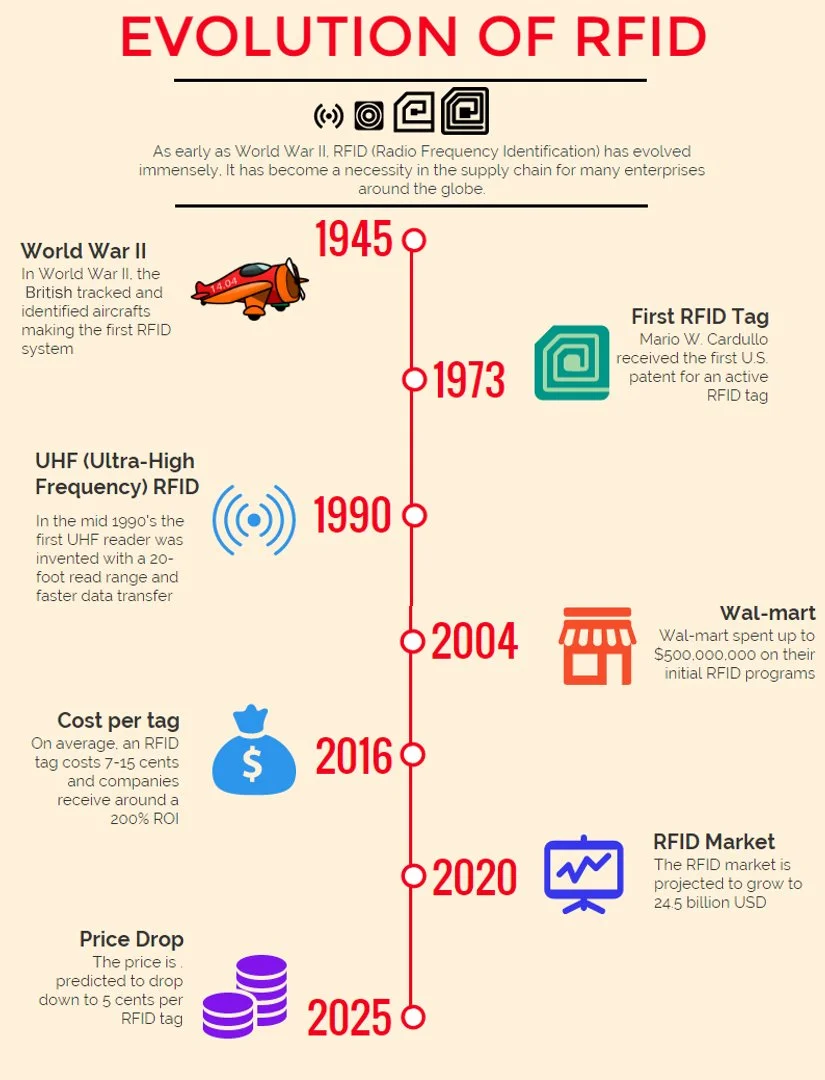
Evolution of RFID graphic from abr.com
A recent article highlighting the 25 Technologies that have changed the world lists the usual blockbuster inventions, such as the Apple iPhone, Wi-Fi, AI, facial recognition, drones, DNA testing, social platforms, quantum computing and bitcoin. However, not all of these world-changing technologies are so famous.
Who knew that Radio Frequency Identification (RFID) is a world-changing technology?
RFID is now a key technology across a growing number of industries. RFID uses electromagnetic fields to automatically identify and track objects. This simple technology has just two components: RFID tags (transponders) and RFID readers. The tags contain data, which are accessed by the reader via radio waves. Unlike barcodes, RFID tags do not require line-of-sight to be scanned, making them more versatile and efficient for asset tracking.
The read range of an RFID tag refers to the distance from which the tag can be detected by the RFID reader. There are two basic types of RFID tags – Passive and active. Passive tags do not require batteries and get their power from the electromagnetic waves of the RFID reader.

Read how Amazon is using RFID for its new Just Walk Out technology where customers can grab clothes, hats, shoes, and more—and simply walk out of the store through an exit gate (even while wearing their purchases) by tapping their credit or debit card, or hovering their palm over an Amazon One palm recognition device. No more checkout lines for clothes!
RFID systems are simple, adaptable, and easily connect with a range of hardware and software. That’s why RFID is a world-changing technology.

Read the article from the National Institutes of Health entitled “Radio Frequency Identification (RFID) in health care: where are we? A scoping review”

Read an article by Atlas RFID store about the many ways that RFID is used to identify and manage wine, beer, and spirits.

RFID is being used to identify, verify and connect to utilities - from buried gas lines to fiber to hydrants. Learn more.
Retail
Now that self-checkout is everywhere, we all understand the frustration of scanning bar codes. Fortunately, many retailers are moving to RFID-enabled shopping carts and baskets to improve the customer experience. Instead of struggling to find a code and scan it, the customer just drops the item in the cart/basket, and it’s scanned. Additionally, RFID-enabled shelves can provide in-depth information on any product via the NFC capability on most cell phones.[1]Logistics
Cargo tracking is essential in the logistics industry. Because RFID tags are available in many forms, they can be affixed to nearly everything, from individual packages to shipping containers, vehicles, train cars and so on. Shipments can be tracked in real-time from origin to destination from a distance. Any interruptions can be quickly detected and resolved, saving time and money.Healthcare
If you’ve been in a hospital, it’s hard to miss the medical equipment wheeled into every available space. Hospitals are continually challenged to efficiently use this equipment, not only because of cost, but also because of regulatory requirements. RFID is making a huge difference in keeping track of every device, as well as it’s maintenance history and what specific device has been used on each patient. In many facilities today, patient wrist bands are also RFID-enabled to ensure the patient is accurately tracked as they move through the treatment process.Manufacturing
Tracking inventory parts and manufactured assemblies has always been a challenge in manufacturing. Bar codes were initially used to address the issue, but the requirement for a line of sight reduces efficiency. RFID delivers efficient inventory tracking without visible markers, enabling product monitoring throughout the manufacturing process.Hospitality
Years ago, hotels replaced locks and keys with RFID-enabled cards. Today, the use of RFID is not limited to access control – now, RFID is used for inventory control as well. RFID tags on hotel and restaurant supplies provide inventory control, while tags on amenities such as hair dryers, robes, and so on, help prevent loss.Agriculture
RFID tags are used for tracking and monitoring livestock as well as for monitoring wildlife.
RFID tags on livestock have become commonplace. Tags are placed on animals soon after birth, tracking their passage from farm to stockyard to supermarket. Besides providing food traceability that is so important for health, RFID helps to manage disease within herds. RFID helps to collect data on individual animals’ behavior and health. That means that outbreaks can be quickly detected and treated as they occur.
In wildlife research, RFID tags are placed on managed endangered species populations, migratory birds, or large mammals. These tags enable researchers to identify individual animals, track their movements, and collect a broad range of data.In both livestock farming and wildlife conservation, asset tracking helps prevent theft and poaching. RFID tags can trigger alarms if an animal leaves a designated area or if an unauthorized person attempts to move an animal.[2]
Museums
Recent headlines highlighting the loss of irreplaceable items at prominent museums highlight the challenge curators face as they must receive, catalogue, store, and display millions of artifacts. A new study showed how RFID can help paleontologists keep track of dinosaur bones from dig to display.RFID can help the visitor experience. When issued an RFID-enabled badge, an audio presentation will be triggered by the proximity to the displayed artwork, providing a wealth of information about the work, it’s creator and history. The data generated from each visitor’s visit can be analyzed to gain insight into visitor traffic patterns, exhibit popularity and even the impact of different lighting and environmental conditions over time. This helps the curator better manage the museum.In art museums, priceless works can be tagged with a discreet RFID label that will trigger alarms if the piece is moved without authorization.
Wine
RFID technology helps vineyards maintain accurate inventory information for real-time tracking of product movements, minimizing the risk of over- or under-stock. RFID tags can monitor temperature and humidity throughout the supply chain to maintain product quality and safety. At the retail location, Point of Sale Inventory Replenishment can automatically update the inventory, ensuring that customers can always get their favorite vintage.Infrastructure
RFID is particularly suited to the management of any type of infrastructure asset, from utility poles to buried valves. A simple RFID tag delivers the location, identity and owner of any asset anywhere. If used widely, RFID would enable cities, airports and utilities to better manage excavation and construction by providing on-site verification of any type of buried asset. The cost of unintentional utility strikes costs the U.S. more than $30 billion annually, according to the Common Ground Alliance. This expense is an unnecessary burden on economic development with no upside.
The RFID market is growing rapidly
The global RFID market is expected to grow from USD 15.8 billion in 2023 to USD 40.9 billion in 2032 at a CAGR of 11.1% during this time. As more and more industries leverage the power of RFID, the applications of RFID will expand. The convergence of RFID, IoT, Artificial Intelligence and Machine Learning will deliver transformative technologies to all sectors, making sense of data and providing a new depth and breadth of understanding.
Berntsen is here to help customers take advantage of this technology with its InfraMarker RFID solution. InfraMarker combines the power of GIS with RFID to deliver accurate, verified asset identification any time and anywhere. See how InfraMarker can change your world.

RFID - resilient and adaptable
Radio Frequency Identification (RFID) has been around for a long time. The precursor technology to RFID was originally developed as a musical instrument by the Russian physicist Leon Theremin, patented in 1928. The Theremin produces music by manipulation of electromagnetic fields around two antennae to produce sound.

Leon Theremin with his radio frequency instrument, circa 1928.
Radio Frequency Identification (RFID) has been around for a long time. The precursor technology to RFID was originally developed as a musical instrument by the Russian physicist Leon Theremin, patented in 1928. The Theremin produces music by manipulation of electromagnetic fields around two antennae to produce sound.
Key technology during WWII
During WWII, the British used radio frequency identification to detect which incoming aircraft were friend or foe. They placed a radio transmitter on each plane. When it received signals from radar stations on the ground, it began broadcasting a signal back that identified the aircraft as friendly. This is the key function of RFID. A signal is sent to a transponder, which wakes up and either reflects back a signal (passive system) or broadcasts a signal (active system).[1]

Hedy Lamarr in a media shot for the movie “The Heavenly Body”, 1944.
Manipulation of radio frequency also played a role in protecting Allied war ships during WWII. In the early 1940s, the Allies were gearing up for a war that would determine the history of the world and were using all available technologies to gain an edge. One of the new weapons was a radio-controlled torpedo that could enhance the range and accuracy of the weapon. A Hollywood actress with a genius-level IQ and an interest in technology heard about this technology. Hedy Lamarr was aware that these torpedoes could easily be jammed by the enemy, rendering them ineffective. Radio jamming is the intentional transmission of radio signals on the same frequency as another communication channel, with the goal of disrupting or interfering with that communication. She believed that if the frequency used to control the torpedo was constantly changing, it would be much more difficult for the enemy to jam the signal and prevent the torpedo from reaching its target.

Replica of the “The Thing” radio listening device.
So she set to work with a friend, Georg Antheil, a composer with an interest in machinery and developed “frequency-hopping” to ensure the radio signals couldn’t be jammed. In frequency hopping, the transmitter and receiver rapidly switch between different channels in a predetermined sequence. This sequence is known to both the transmitter and the receiver, and it is usually designed to cover a wide frequency range to increase the likelihood of finding a clear channel. Lamarr and Antheil received a patent for this technology and donated it to the US Navy, never getting any money from it.[2]
Later, radio frequency technology was used by the Soviets to produce a covert listening device. In 1945 the Soviet Union presented a hand-carved ceremonial seal of the USA to the US ambassador, Averell Harriman. Unfortunately, this wasn’t just a gift, it was a new kind of listening device. Hidden within the artwork was an antenna activated by radio waves that were directed at the US embassy by the Soviets. This served as a microphone and broadcast private conversations back to the Soviets. It wasn’t initially found by embassy staff because the device had no batteries or wires to detect. For seven years, private conversations in Harriman’s study were unknowingly broadcast to the Soviets.[3]
Computers & RFID - a powerful combination
By 1973, memory was added to the radio frequency technology. It consisted of a transponder with 16 bit memory for use as a toll device for the New York Port Authority. The basic patent covers the use of radio frequency (RF), sound and light as transmission carriers.[4] The commercial uses of the technology for passive, contactless identification were apparent, and rapid development and commercialization began in earnest.

Graph derived from a market report by MarketsandMarkets, titled RFID Market Size, Share, Statistics and Industry Growth Analysis Report by Offering (Tags, Readers, Software & Services, Tag Type (Active, Passive), Wafer Size, Frequency (Low Frequency, High Frequency, Ultra-high Frequency), Form Factor, Material, Application and Region - Global Forecast to 2032.
Today, the market for RFID is exploding. According to a comprehensive report by MarketsandMarkets, the global RFID market size is projected to reach USD 40.9 billion by 2032 from USD 15.8 billion in 2023; it is expected to grow at a CAGR of 11.1% from 2023 to 2032. This growth is indicative of the increasing adoption of RFID technology as a powerful enabler of connectivity and data visibility.[5]
Now, RFID is used across all sectors of industry, from agriculture to manufacturing, education, health care, retail, supply chain management – anywhere the instantaneous, contactless and precise identification and tracking of any item is needed. Its simplicity and versatility means that it can be combined with other technologies to deliver location-based data immediately. For example, RFID is being used with artificial intelligence technologies to reliably predict patient falls and detect human activities. It can help provide insight into transport conditions for perishable products, and support sustainability by helping to identify and reduce waste in supply chain management.
RFID & GIS
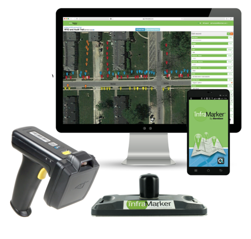
RFID is now being tapped to help manage all types of assets in combination with Geographic Information Systems (GIS). When used together, GIS and RFID deliver accurate, verified information about any type of asset – even below-ground. This information is incredibly useful when re-locating buried assets before excavation. RFID means that field workers can know exactly what’s below simply by scanning the buried RFID asset tag through InfraMarker RFID apps that display that specific asset’s data.
Berntsen’s partnership with Esri gives users of the popular Survey123 and Field Maps data collection apps the opportunity incorporate the benefits of InfraMarker RFID into their asset tracking. Berntsen’s partnership with HID means that its RFID tags and readers come in a wide variety of configurations, from rugged underground magnetized markers to ultra-thin labels designed for accurate and reliable inventory control.
RFID Journal Live Conference

In a few days, experts will be unveiling the future by sharing the latest applications, enhancements, and new advancements RFID technology. The Conference brings together users, developers, and exhibitors from all over the world at the MGM Grand in Las Vegas from April 9-11. Mike Klonsinski, president of Berntsen will be presenting a session about a unique use of our versatile InfraMarker RFID technology:
Dinosaur Dig to Display: Transforming Asset Management in the Field
Tuesday, April 9 | 1:50 pm to 2:30 pm Room No: 357
Session Description
When 347 fossil specimens were discovered on Standing Rock Sioux lands in South Dakota, the Earth Science Foundation (ESF) turned to technology to advance their fossil recovery operation. The ESF team led the excavation, documentation and handling of paleontological specimens and needed an innovative solution. In response to that need, InfraMarker RFID, HID and Esri ArcGIS joined forces to deliver best asset management practices.
Learn how the solution uses the combined technology to improve field workflows, tracks, and traces bones from field to display, and aids dashboards for operations managers and remote stakeholders.
RFID continues to be a core technology for our future, and the RFID Conference highlights how this simple technology is making our lives better. We look forward to seeing you there!

Federal agencies get the job done
For more than 50 years, Berntsen has worked alongside federal agencies to provide useful and quality products. From monuments that can be set in wetlands to RFID markers that integrate with Geographic Information Systems (GIS), federal agencies rely on Berntsen to deliver quality products that help them fulfill their missions.
For more than 50 years, Berntsen has worked alongside federal agencies to provide useful and quality products. From monuments that can be set in wetlands to RFID markers that integrate with Geographic Information Systems (GIS), federal agencies rely on Berntsen to deliver quality products that help them fulfill their missions.
See us at booth 830 at the Esri FedGIS Conference on February 13-14, 2024

In partnership with Esri, Berntsen is looking forward to demonstrating how InfraMarker RFID can help federal agencies better manage their diverse assets at the upcoming Esri FedGIS Conference. Stop by booth 830 to see how the InfraMarker RFID App for ArcGIS can help you identify, verify and update data for any type of asset in the field with a simple scan. Anything (even underground) that can be marked with an RFID tag can connect to ArcGIS for accurate identification and management. We look forward to seeing you there!
Federal Agencies – partnering with industry to get the job done
Federal agencies are key to maintaining a safe, stable, and thriving nation. From the Department of Defense, that protects Americans at home and abroad, to the Department of Interior that manages America’s vast public lands, to NASA, tasked with exploring the unknown for all the citizens of our planet, federal agencies provide the structure and do the work that makes our country thrive.
One thing these agencies have in common is that they manage many types of assets across vast spaces. From ensuring that gas pipelines are built and operated safely, to marking out trails in national parks, to building dams, highways and runways, these agencies rely on the private sector for products and technologies that help get more done with fewer resources.
Since the foundation of our country, federal agencies have quietly been getting the job done, ensuring stability and growth. This vital structure didn’t happen overnight, and it’s interesting to see the evolution of how these agencies developed.
Department of Defense (DOD)
The DOD is America's largest government agency, with more than 2,870,235 employees and service members. Tracing its roots back to pre-Revolutionary times, the department has evolved with our nation.
The Army, Navy, and Marine Corps were established in 1775, to support the American Revolution. In 1789, Congress created the War Department, responsible for both the Army and Navy until the founding of a separate Department of the Navy in 1798. After World War II, the War Department was reorganized and by 1949, the command structure was unified, and the Department of Defense was created.
Today, the DOD has four branches (Army, Navy, Air Force, and Coast Guard) with the Marines organized under the Navy, and the new Space Force organized under the Air Force. The branches are made up of 34 agencies, including the National Geospatial-Intelligence Agency; and divisions including the US Army Corps of Engineers. Additionally, two organizations are staffed with uniformed service members but don’t report to the Secretary of Defense. These include the Public Health Service Corps (reporting to the Surgeon General who reports to the Assistant Secretary of Health in the Health and Human Services Department) and the National Oceanic and Atmospheric Administration, (NOAA), reporting to the Secretary of Commerce[1]. Interestingly, the NOAA includes the National Geodetic Survey, our oldest scientific agency. In 1807, President Thomas Jefferson founded the U.S. Coast and Geodetic Survey (as the Survey of the Coast) to provide nautical charts to the maritime community for safe passage into American ports and along our extensive coastline[2].
Berntsen has been serving the DOD for decades. In fact, it was a request from the DOD that sparked a new way of creating survey markers.

The first logo marker in cast aluminum.
Back in the late 1970s, the DOD asked Berntsen if the company could create survey disks for a project in Saudi Arabia. The catch was that the disks needed to include Arabic text and the country’s coat of arms -- a palm tree and crossed swords. Back then, the lettering on survey disks was created using zinc letters glued to a wooden pattern. No Arabic zinc letters were available, and there was no way to include artwork on a disk without going through an expensive and time-consuming engraving process. Long story short, by adapting paste-up and letterpress printing processes to metalwork, Berntsen created the first survey markers using Arabic lettering and illustrations. Today, our survey markers are used across many federal agencies.
Read the story of the first logo marker in American Surveyor.
The Department of Interior (DOI)
Although the idea of a Department of Interior was originally considered in the very first congress in 1789, but instead created the Department of State. However, after the Louisiana Purchase (In 1803) and the lands acquired in the Mexican-American War (1848), it became clear that the vast lands required direct management, rather than being parceled out to other agencies to manage.

Appalachian Trail Marker for the National Park Service
In 1848, the Secretary of the Treasury Robert J Walker did a comprehensive review of the duties of the agencies under his control and other agencies throughout the federal government. He determined that the General Land Office, along with the Indian Affairs Office (in the War Department), The Patent Office (in the State Department), and the pension offices (in the War and Navy departments), had little in common with their (respective) departments. He suggested that they be moved into a new department and went about drafting a bill to accomplish his objective. On March 3, 1849, the legislation was approved by the Senate, thus creating a cabinet agency known as the Department of the Interior (DOI). Subsequently, Interior functions expanded to include the census, regulation of territorial governments, exploration of the western wilderness, and management of the D.C. jail and water system.
Over time, additional functions have been added to and removed from the DOI’s management. Those added include: the US Geological Survey, 1879; the Bureau of Reclamation, 1902; the Bureau of Mines, 1910; the National Park Service, 1916; the US Fish and Wildlife Service, 1940; and the Bureau of Land Management, 1946.
Responsibilities have been moved to other departments. In 1925, the Patent Office was transferred to the Department of Commerce. In 1930, the Bureau of Pensions was transferred to the Veterans Administration[3].
Nevertheless, the purview of the DOI is massive. For example, one of its entities, the Bureau of Land Management oversees 245 million acres of public lands, manages 30% of the nation’s mineral resources, and contributes $1.2 billion annually in economic contributions, such as solar and wind power and geothermal energy[4].

Navajo Nation bronze cadastral survey marker
Another service, the National Park Service, includes 428 areas covering more than 85 million acres in every state, the District of Columbia, American Samoa, Guam, Puerto Rico, and the Virgin Islands. These areas include national parks, monuments, battlefields, military parks, historical parks, historic sites, lakeshores, seashores, recreation areas, scenic rivers and trails, and the White House[5].
Over the years, Berntsen has supported the DOI by delivering innovative and quality products for decades. From thousands of monuments for the Bureau of Land Management, to custom bronze markers for the Navajo Nation to markers for the National Park Service, to RFID-enabled asset marking, Berntsen has been supporting federal agencies since its inception.
Department of Transportation (DOT)

Brochure for the first lightweight magnetic aluminum alloy monument.
The Department of Transportation is a newer executive agency, created during the Johnson administration in 1967, reporting directly to the President. The agency coordinates funding and manages aviation, rail, highway, public transit, hazardous pipelines and other functions involved in the safe transit of people and goods[6].
A request from the Wisconsin Department of Transportation (WISDOT) triggered the invention that built Berntsen. Back in the early 1970s, Peter Berntsen heard about the need for a lighter, more portable survey monument to be used by WISDOT. As owner of Berntsen Cast products, Peter was in the position to solve the problem. With the help of a metallurgist at the University of Wisconsin, Berntsen developed a corrosion-resistant, aluminum-alloy magnetic monument weighing just 8.5 pounds. This innovative monument (the W-1B) proved to be so durable and popular that it established Berntsen as the leader in marking the infrastructure of the world.
Berntsen – providing the right tools at the right time
Over the years, the DOD, DOI, DOT and their bureaus and services have all relied on Berntsen to fulfill their missions - including the US Forest Service, the US Department of Agriculture, the Bureau of Reclamation, US Fish and Wildlife Service, the US Geological Survey, the National Park Service, NASA, and many more.
Berntsen markers delineate the borders of national parks, and our Carsonite trail markers help citizens safely enjoy scenic trails. Berntsen offers a full toolbox for right-of-way management, from utility posts and decals to metal markers to passive RFID tagging. Our InfraMarker Connected RFID links any type of physical asset to GIS, streamlining the identification, tracking and management of everything from pipelines to dinosaur fossils.
See us at the FedGIS Conference!
In partnership with Esri, Berntsen is looking forward to demonstrating how InfraMarker RFID can help federal agencies better manage their diverse assets at the upcoming Esri FedGIS Conference. Stop by booth 830 to see how the InfraMarker RFID App for ArcGIS can help you identify, verify and update data for any type of asset in the field with a simple scan. Anything (even underground) that can be marked with an RFID tag can connect to ArcGIS for accurate identification and management. We look forward to seeing you there.

GIS Day - Mapping our past with the help of RFID
It’s Geographic Information Systems (GIS) Day! Since 1999 when it was first celebrated as the grand finale to Geography Week, GIS has been quickly put to use by many professions, industries and researchers. Today, GIS is becoming indispensable for paleontology - with the help of RFID.
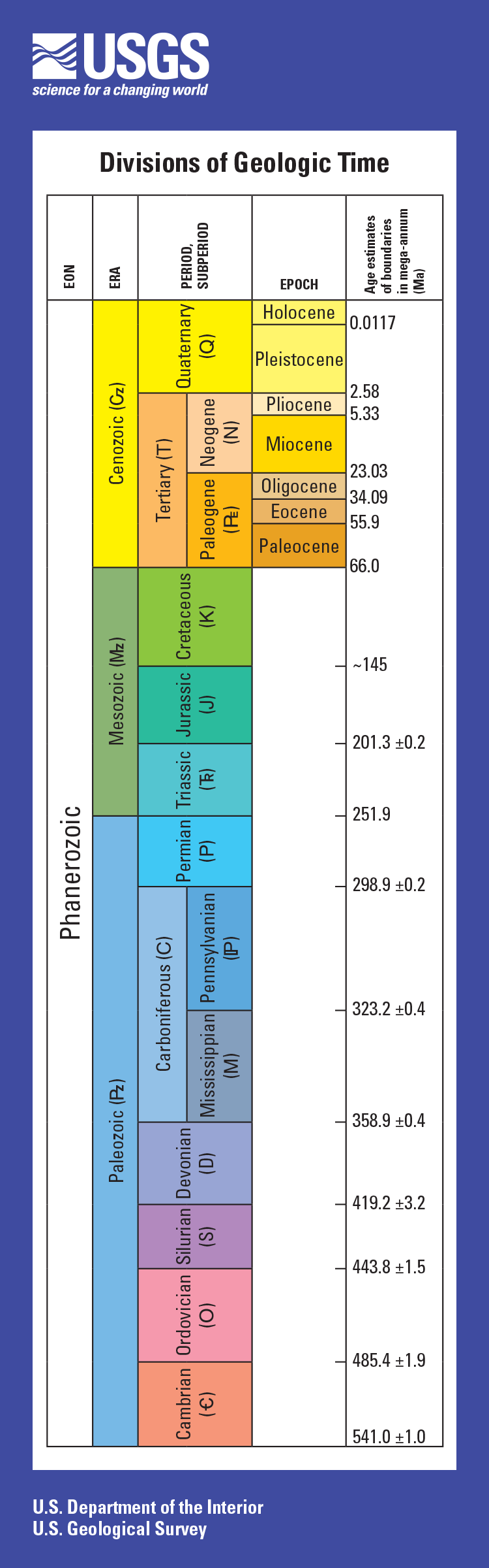
Ages shown for divisions of geologic time are general representations. Ages in mega-annum mean millions of years before present. Box heights are related to how long time periods lasted; different scaling factors are used for the column on the front of the bookmark and for the column on the back, which represents a much longer time period. Map symbols are in parentheses. For more specific age information, see U.S. Geological Survey Fact Sheet 2018–3054 (https://doi.org/10.3133/fs20183054).
It’s Geographic Information Systems (GIS) Day! Since 1999 when it was first celebrated as the grand finale to Geography Week, GIS has been quickly put to use by many professions, industries and researchers. Today, GIS is becoming indispensable for paleontology - with the help of RFID.
The Age of Dinosaurs
According to the United States Geological Survey (USGS), the 'Age of Dinosaurs' (the Mesozoic Era) included three consecutive geologic time periods (the Triassic, Jurassic, and Cretaceous Periods). Different dinosaur species lived during each of these three periods. For example, the Jurassic dinosaur Stegosaurus had already been extinct for approximately 80 million years before the appearance of the Cretaceous dinosaur Tyrannosaurus. In fact, the time separating Stegosaurus and Tyrannosaurus is greater than the time separating Tyrannosaurus and you.
At the beginning of dinosaur history (the Triassic Period), there was one supercontinent on Earth called Pangea. Many dinosaur types were spread across it. However, as Pangea broke apart, dinosaurs became scattered across the globe on separate continents, and new types of dinosaurs evolved separately in each geographic area (1).
When were fossils recognized as ancient dinosaur remains?
Fossils have probably been found throughout human history, despite not being recognized for what they are. Discoveries of their bones were often attributed to giant versions of known animals, or even giant people. Perhaps dinosaur bones inspired the stories of griffins, giants, and dragons.
Fossils of dinosaurs, described by a Chinese historian in the 4th century BCE, were labeled as dragon bones, while "dragon bones" were prescribed for ailments from madness to diarrhea. There’s no evidence as to the effectiveness of this treatment, however.
In 1822, Mary Ann Mantell was accompanying her husband, obstetrician, and paleontologist Gideon Mantell, on a visit to a patient in Sussex, England, when she noticed something at the side of the road. Looking closer, she found large teeth embedded into the rock.
Her husband Gideon realized that the fossil belonged to a creature unknown to science. He continued to study it and later named it Iguanadon after its iguana-like teeth. Later, paleontologist Richard Owen examined a number of fossil sets and concluded that Iguanodon, Megalosaurus, and Hylaeosaurus fossils were from "a distinct tribe or sub-order of Saurian Reptiles" which he termed, "dinosauria". (2)
Earth Science
Today, an entire field of science is dedicated to the study of the earth, aptly named Earth Science. It includes four branches of study, including geology, meterology, oceanography and astronomy. Geologists specializing in the earth’s history are palentologists, and this group studies fossils to gather evidence to piece together what the ancient past might have been like.

Norman Ross of the division of Paleontology, National Museum, preparing the skeleton of a baby dinosaur some seven or eight million years old for exhibition. , 1921.
It’s getting harder and harder to access places where fossils are plentiful and the Earth Sciences Foundation, Inc. (ESF) was founded to help locate and protect fossils before they disappear. The foundation’s goal is to get people excited about and involved in earth sciences. Fields of study include everything from paleontology, to GIS to surveying.
One of the biggest issues facing scientists is keeping track of fossils, both in the ground and after they have been shipped to museums or universities for study. Recent headlines attest to the difficulty museums face in keeping track of all of their artifacts. Fortunately, there is an elegant solution to this pervasive (and costly) problem.
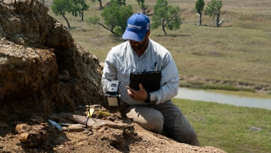
Each fossil was identified with a unique RFID tag that connected it to its record in ArcGIS. Data about the fossil was added throughout the process - accessible to all stakeholders in real time.
Berntsen has been working with The Earth Sciences Foundation to leverage the power of RFID to use GIS to track and manage dinosaur bones. Our InfraMarker Connected RFID has the potential to revolutionize how these precious artifacts are tracked from the time they are excavated until they are put on display in museums or sent to universities across the world for study. A simple RFID tag connected to GIS will allow scientists to see all the data about any specific artifact, including where it was found, photographs, video, notes and any other information about it, simply by accessing GIS. The RFID tag will stay with each artifact throughout its academic journey, making both the information and the location accessible at any time.
Dig to Display: Transforming Dinosaur Bone Asset Management with InfraMarker RFID and GIS

View of bone fossil locations on a map, with the selected bone displaying its data.
A recently-published study describes how dinosaur bones at Standing Rock Sioux lands in South Dakota were tracked from dig to display. ESF staffers used ArcGIS, Survey123 and InfraMarker RFID to track 347 artifacts from excavation to storage to display.
The bone tracking and management process is simple. Each discovered fossil was ‘tagged’ in the field with a tiny HID RFID marker to establish a unique digital and physical ID. That ID, and contemporaneous information, was captured by a field tech using a tablet with data collection software connected to a GIS platform. RFID scans of the bone’s tag tracked the bone as it moved through various zones from field to storage to cleaning to display, adding data to its GIS record. Simultaneously, hundreds of miles from the dig site, the contractor’s GIS platform displayed a map of original and current bone location and status as it moved from field to institute. Throughout the process, all RFID interrogation data was collected in the cloud, providing near real-time visibility of bone status by auditors hundreds of miles from the dig site.

One of the RFID tags used in the study.
Saves time; near perfect accuracy
Study results found a reduction of field data collection time by 80 percent, nearly perfect tracking of bones through the cycle from field to museum, and enabled easy data sharing and auditing of field work by related organizations.
The study demonstrated the benefits of the RFID/GIS integration that are making a huge difference in many industries - from utility management to agriculture, forestry and manufacturing. Another recent study shows how RFID can help identify and verify underground utilities, streamlining utility management and enhancing safety.
RFID and GIS - Accuracy, versatility and power
RFID and GIS expanding the benefits of location intelligence to new applications and streamlining access to valuable assets - from buried utilities to museum artifacts. Sales of RFID and GIS are exponentially growing because of the tremendous advantages these technologies offer across industries. When RFID is integrated with GIS through InfraMarker, accurate asset management is enabled by connecting the physical asset to its digital files that can be quickly accessed on-site with a simple RFID scan (or even a NFC scan from a cell phone). RFID provides asset authentication at the site of any asset, streamlining field work and improving accuracy and automatically generating tracking information. Any organization that needs to track and manage assets across space and time will benefit from incorporating InfraMarker RFID with their GIS.

It’s National 811 Day —
811 Day was created to bring attention to a significant but little-known issue – the high cost and safety impacts of underground utility strikes.
Quantifying the cost and safety impacts of utility strikes is difficult. A compilation of various studies estimates that the direct cost of each strike is $4,000 -- but that doesn’t take into consideration the cost to repair and restore the damage.

Little-known but incredibly important
811 Day was created to bring attention to a significant but unfamiliar issue – the high cost and safety impacts of underground utility strikes.
Quantifying the cost and safety impacts of utility strikes is difficult. A compilation of various studies estimates that the direct cost of each strike is $4,000 -- but that doesn’t take into consideration the cost to repair and restore the damage. Taken together, the cost of the strike plus the cost of restoration, the total is 29 times the cost of the direct damage itself [1]. Because utility strikes are often not reported, the frequency of occurrence is merely an estimate. With more than 20 million miles of buried pipelines, cables, wires and other facilities, the Common Ground Alliance (CGA) estimates that there are at least 400,000 utility strikes per year in the United States. In 2021, the cost of utility strikes to the US economy was estimated to be more than $30 billion.
Utility strikes have been a problem for a long time – ever since the 1850s when the first underground sewer systems were built in Chicago and Brooklyn.
Act of Congress
It wasn’t until 1994 that the government got involved. At that time, Congress required each state to develop a One-Call system with a centralized number to call in advance of digging. The goal of the one-call system is simplicity. Any person or company planning to excavate can call an in-state number and the utility companies would be notified to send a Utility Locator to find and mark utilities using spray paint and/or flags. Unfortunately, the number of One-Call Centers quickly grew to 71, each with its own 10-digit phone number, making it confusing and taxing to notify the right people before breaking ground.
In response, in 1995, the FCC designated 811 as the nationwide number to call (or click) to protect pipelines and other utilities from excavation damage.
Today, 811 is contacted nearly 40 million times annually [2].
Despite the fact that use of 811 one-call centers rose by eight percent from 2020 to 2021, “No notification made to 811 center” remains the top root cause of utility strikes with over a quarter of all damages still attributed to no notification)[3].
Much more to be done
Although it’s simpler than ever to call for utility location, utility strikes remain a major drag on the American economy. Fortunately, emerging technology is being used to produce precise maps of underground utilities that speed the process of identifying and locating underground utilities.
For example, Geographic Information Systems (GIS), are being used by growing numbers of utilities, municipalities and excavators to create and share data about underground utilities. Unfortunately, having an accurate map of all utilities in a given area is rare, because not every contractor or owner working on a job site uses GIS to map utilities. That’s when another technology, Radio Frequency Identification (RFID), can make all the difference. Magnetic RFID tags can be buried with any type of utility and will display its identity, owner and other information with a simple scan. This data can be incorporated into GIS (such as Esri’s ArcGIS) through data collection apps on mobile devices. RFID is agnostic, so it will work with any utility, above or below ground.
RFID and GIS are key
Passive RFID tags don’t require power (they activate only when scanned) so they can last underground for years. A recently released study describes how RFID has been used to mark and manage utilities over a period of seven years. The study concluded that magnetic RFID marking, coupled with GIS mapping, is a low-cost, reliable solution for underground infrastructure locating and management.
Marking underground utilities with magnetic RFID is a long-term solution that streamlines future utility locating processes while providing the means to connect to digital mapping systems for efficient utility management -- from water pipes to fiber-optic cables. Utility location verified by RFID, provides a highly accurate method for utility owners to manage all of their infrastructure facilities.
Today, on 8/11 calling 811 remains essential part any excavation, from individuals working in their backyards to construction companies about to break ground on a new project.
References:
[3] https://dirt.commongroundalliance.com/2021-DIRT-Report/Executive-Summary#mainContentAnchor
Sources:
https://www.4manalytics.com/blog/29-1-the-cost-of-striking
The 811 Logo is a registered trademark of the Common Ground Alliance

Marking and Mapping – Two Factor Verification for Underground Locating
It’s spring and construction is booming . . . hopefully with fewer actual “booms”, caused by utility strikes. Safe digging is something that’s near and dear to surveyors and any profession that involves excavation. As I mentioned in my last blog, preventable utility strikes cost at least $60 billion annually, not to mention the loss of life and life-altering injuries that can occur.
Blog by Emily Pierce, PLS, CFedS
It’s spring and construction is booming . . . hopefully with fewer actual “booms”, caused by utility strikes. Safe digging is something that’s near and dear to surveyors and any profession that involves excavation. As I mentioned in my last blog, preventable utility strikes cost at least $60 billion annually, not to mention the loss of life and life-altering injuries that can occur.
Geographic Information Systems (GIS)
GIS has emerged as a leading approach to managing utility assets and will become an essential tool for subsurface utility management. But regardless of how accurate GIS maps become, there will always be the need to validate the digital representation of the underground assets depicted in the maps with high quality in-field marking products. Mapping and marking is required.
In today’s world, this is called ‘two-factor’ verification and it is used in solutions like Uber (mobile map coupled with driver verification on arrival), online banking (text to phone to validate your account ownerships you) and your doctor’s office (“please tell me your name and date of birth”).
Surveyors have practiced this for years by using maps and then relying on Berntsen survey markers in the field. Two-factor verification drives safety, reduces errors in identification, and improves operational performance. There is no industry with greater need for two-factor verification than underground locating.
Technology to the Rescue
It is this two-factor verification that Berntsen has been working on with its InfraMarker RFID underground locating solutions. Tying an underground RFID asset identifier to a GIS delivers the best of both worlds – an accurate map with in-field verification.
I can’t help but think of the impact Connected RFID could have on preventing utility strikes if it was widely used. An RFID underground marker has a unique identifier tied to a GIS record so a field worker can identify the asset or particular location – not simply type of utility – before excavating. And RFID is utility agnostic, so the same locating and identification process works for water, gas, electric, or fiber.
We use two-factor verification to make sure we don’t get into the wrong Uber. Why can’t we take the same two-factor approach to make sure that we have safer underground digging?
Questions? Let us know!

Blossoming Blooms
Harmful algae blooms (HABs) are occurring more and more frequently in lakes, rivers, streams and coastal areas across the United States. Further, HABs are occurring where they were never found in the past. View a map from the Natural Resources Defense Council that tracks HABs across the United States.
CONTAINING THE THREAT OF HARMFUL ALGAL BLOOMS (HABS) IN URBAN ENVIRONMENTS
Harmful algae blooms (HABs) are occurring more and more frequently in lakes, rivers, streams and coastal areas across the United States. Further, HABs are occurring where they were never found in the past. View a map from the Natural Resources Defense Council that tracks HABs across the United States.
The chart below tracks the number of reports of algal blooms over time up to October 2021.
NUMBER OF HARMFUL ALGAL BLOOMS IN THE U.S. BY YEAR

WHAT IS A HARMFUL ALGAL BLOOM?
An algal bloom is an overgrowth of microscopic algae or algae-like bacteria in fresh, salt or brackish water. Many type of algae or bacteria can produce algal blooms; not all are toxic and not all are harmful. Less than one percent of algal blooms produce toxins; harmful algal blooms (HABs) are those that have negative impacts on humans, marine and freshwater environments and coastal areas.
The most common types of harmful freshwater algal blooms are caused by cyanobacteria. Some types of cyanobacteria can produce dangerous cyanotoxins. Some of these cyanotoxins can attack the liver, kidneys, central nervous systems, skin and lungs, resulting in serious damage or even death.
WHAT CAUSES HARMFUL ALGAL BLOOMS?
HABs can occur naturally, but the increasing prevalence and frequency is caused by:
Nutrient pollution, such as agricultural runoff, wastewater and stormwater runoff (which is increasing due to more frequent severe rainfall events).
Warmer temperatures.
Still water, such as in dams, canals and other man-made waterways.
STORMWATER MANAGEMENT – THE FIRST LINE OF DEFENSE AGAINST HABS
HABs have a significant, yet largely unmeasured economic impact. Looking at just the recreation and tourism industry, a single harmful algal bloom event in a lake in Ohio cost $37-$47 million in lost tourist revenue over two years.*

The reduction of nutrient pollution is the most accessible and effective method of reducing algal blooms in urban areas. It is estimated that 10 trillion gallons of untreated stormwater now flow into our lakes, rivers, streams and coastal areas.
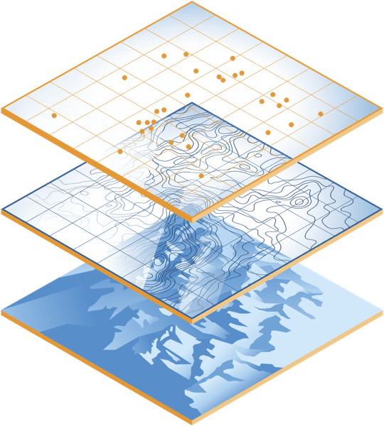
Many municipalities are implementing asset management programs (AMPs) to help quantify and manage their stormwater infrastructure. Because infrastructure was built over a long period of time, it’s likely that documentation fragmented and inaccurate, which makes efficient maintenance very difficult. Actually knowing the location and condition of infrastructure assets goes a long way in creating a proactive plan to inspect, manage and repair existing assets.
SMALL INVESTMENTS IN PROVEN TECHNOLOGY CAN MAKE A BIG DIFFERENCE

Reading an RFID marker on a catch basin.
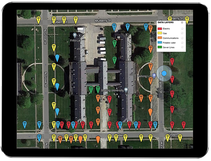
Fortunately, cost-effective technology is available to help make efficient asset management available to municipalities. Rather than keeping track of stormwater assets on paper and then digitizing the information, many municipalities have gone digital, using Geographic Information Systems (GIS) to keep track of their catch basins, swales, hydrants and other assets. However, in many cases, even if all the assets are viewable on a GIS system, truly useful data is not.
For example, a single intersection may have literally dozens of manholes, storm drains, catch basins, hydrants and other assets that require regular inspection and maintenance. GIS systems don’t have a way to identify discrete assets in close proximity. That’s where the InfraMarker system comes in. It offers a way to link verified physical location with the digital world using simple, proven technology.
Any asset that is marked with a RFID tag can be linked to unlimited asset information in a GIS using a simple mobile app. Field technicians can verify with certainty where they’re at and then link their maintenance activity with that specific asset – no guesswork or wasted time involved.
Asset managers benefit because they can view all assets online and delve into each specific record to view videos, photos and any other documentation the field tech has attached to the specific tag. An audit trail has been created so asset managers can schedule inspections and maintenance knowing that there will be no confusion or wasted time in the field dealing.
*Estimated Annual Ecomonic Impacts from Harmful Algal Booms (HABs) in the United States, WHOI-2000-11.