Damage prevention saves lives and money
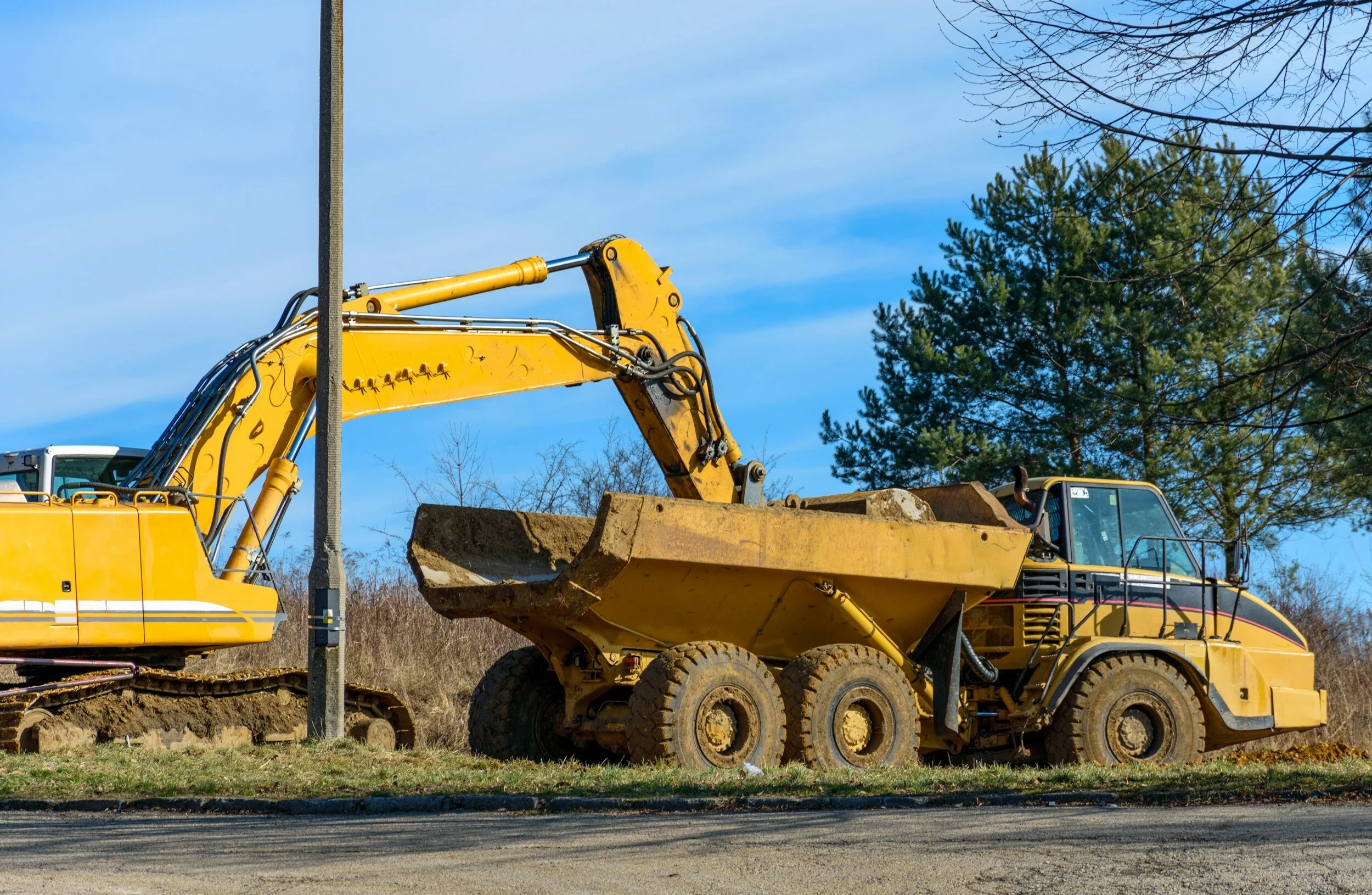
April is recognized by Congress and most Governors across the U.S. as National Safe Digging Month as shovels (and backhoes) hit the ground for a busy season. It’s well known that excavation is a dangerous business. Excavation strikes on public utility lines lead to more than 2,000 injuries and 400 deaths each year. The Common Ground Alliance (CGA) states that accidental utility strikes cost the U.S. at least $30 billion annually, based on self-reported data by stakeholders and state 811 call centers. And it looks like things are getting worse, not better.
April is recognized by Congress and most Governors across the U.S. as National Safe Digging Month as shovels (and backhoes) hit the ground for a busy season. It’s well known that excavation is a dangerous business. Excavation strikes on public utility lines lead to more than 2,000 injuries and 400 deaths each year[1]. The Common Ground Alliance (CGA) states that accidental utility strikes cost the U.S. at least $30 billion annually, based on self-reported data by stakeholders and state 811 call centers. And it looks like things are getting worse, not better.

From the CGA 2022 DIRT Report
Trends indicate more, not fewer damages
The CGA’s most recent data show that the number of incidents is increasing. A three-year trend (2020-2022) points to a 9.34 percent increase in utility strikes. With more than a half-trillion dollars allocated to new infrastructure in the U.S. over five years, it’s essential all organizations involved in excavation prioritize ways to reverse this dangerous and costly trend.
Many organizations are involved in excavation - professional excavators, landscapers, contractors, utilities, local, state and federal agencies, site owners and others. A single excavation site has dozens of contractors working in the same space at the same time. Surprisingly, there are few national guidelines for safe excavation processes, except for the one-call system established in 1994. This law directed states to have a phone number to call for underground locating. In most states, that number or link is 811.
Calling (or clicking on) 811 for locating services before excavation greatly reduces the risk of utility strikes. Unfortunately, nearly 25% of all reported utility damages result from NOT calling 811, as this chart from CGA shows.
An industry group, the Infrastructure Protection Coalition, is working to standardize the use of 811 by all parties involved in excavation. Their report states that

“A handful of states account for more than 20 percent of the national waste [related to 811], a combined $13 billion, because of 811 policies that lack teeth and, in some cases, do not require mandatory reporting of damage to utility lines. . . [The analysis shows that] these costs and the increased risk to public safety could be substantially reduced if states with the worst records adopted more effective practices and procedures already in use in other parts of the country.”
811 Emergency, National Report, 6/15/2022, Infrastructure Protection Coalition
Focus on policy
It appears that now is the time to call for a national approach to damage prevention. The CGA has just announced the formation of the Damage Prevention Action Center, an entity made up of industry leaders to advocate for data-driven legislative and regulatory policies and industry practices that protect our critical underground utility infrastructure and those who work and live near these important assets. It’s vital that legislation be based on data and best practices, and this group aims to ensure fact-based regulation.
Ambitious goals – achievable with technology
The CGA has set an ambitious goal of reducing damages by 50% over the next five years. Consistent and widespread use of 811 is key, but to reach that goal, other priority action areas must be leveraged. “For facility owners, GIS-based mapping of assets and communication are urgently needed to improve locating timelines and accuracy.”
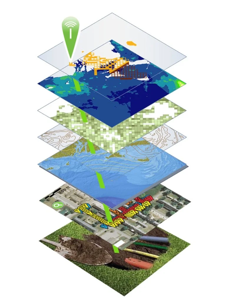
Geographic Information Systems (GIS) are already used extensively by municipalities and utilities across the country. These platforms are ideal for mapping and visualizing underground infrastructure and are already in use by many utilities and municipalities across the country.
Adding processes for mapping underground utilities as they are they are installed (or uncovered by new excavation) can provide highly accurate, shareable maps for every contractor on a construction site. These efforts are already underway. For example, Esri, a global leader in GIS, delivers capabilities designed to make the visualization, identification, mapping and management of underground utilities accessible for all stakeholders. Its ArcGIS platform is ideal for generating accurate visual depictions of location and other data in layers. This platform uses data from a wide range of sources, including field operations. Field workers use cell phones or tablets to collect data in real time as they install underground infrastructure.
To ensure location data is absolutely accurate for future excavations, Esri offers the InfraMarker RFID app that integrates with its Field Maps or Survey123 field data collection software. As utilities are buried (or uncovered during excavation), RFID tags are placed on or near critical points, such as fiber junctions, valves, places where multiple assets converge and so on. Essential data about the asset, its owner and location data are written to each tag for future on site location and verification. This data is linked to ArcGIS via the InfraMarker/data collection apps, providing verified location data of the buried utility while also linking it to critical information about the asset, including video, schematics, maintenance and other data.

What this means is that in the future, when excavation on the same site is required, the exact location, owner and nature of underground assets can be verified on the spot. Buried RFID tags can be read before ground is broken from above using RFID readers connected to the Esri/InfraMarker data collection apps. Above ground RFID tags can also be read with a cell phone held close proximity to the tag.
The data owner can choose to share selected data with other contractors, preventing damage to their critical underground facilities during excavation.
Accurately mapping of underground assets is key to preventing damage. If used consistently, GIS and RFID deliver in-field location verification and identification data that streamline buried asset locating – preventing costly utility strikes and construction delays.
See it for yourself
Berntsen International supports CGA’s mission and will be showing InfraMarker RFID at the upcoming CGA Conference and Expo April 14-18 at the Broadmoor in Colorado Springs, Colorado in booth 322. We look forward to seeing you there!
References:
NP Case Study Minnesota Utilities Mapping (commongroundalliance.com)
https://www.linkedin.com/pulse/striking-balance-unearthing-facts-solutions-utility-line-machuca/
https://www.theutilityexpo.com/news/digging-safely-preventing-underground-utility-stri
https://www.amprobe.com/consequences-of-striking-underground-infrastructure/
Federal agencies get the job done
For more than 50 years, Berntsen has worked alongside federal agencies to provide useful and quality products. From monuments that can be set in wetlands to RFID markers that integrate with Geographic Information Systems (GIS), federal agencies rely on Berntsen to deliver quality products that help them fulfill their missions.
For more than 50 years, Berntsen has worked alongside federal agencies to provide useful and quality products. From monuments that can be set in wetlands to RFID markers that integrate with Geographic Information Systems (GIS), federal agencies rely on Berntsen to deliver quality products that help them fulfill their missions.
See us at booth 830 at the Esri FedGIS Conference on February 13-14, 2024

In partnership with Esri, Berntsen is looking forward to demonstrating how InfraMarker RFID can help federal agencies better manage their diverse assets at the upcoming Esri FedGIS Conference. Stop by booth 830 to see how the InfraMarker RFID App for ArcGIS can help you identify, verify and update data for any type of asset in the field with a simple scan. Anything (even underground) that can be marked with an RFID tag can connect to ArcGIS for accurate identification and management. We look forward to seeing you there!
Federal Agencies – partnering with industry to get the job done
Federal agencies are key to maintaining a safe, stable, and thriving nation. From the Department of Defense, that protects Americans at home and abroad, to the Department of Interior that manages America’s vast public lands, to NASA, tasked with exploring the unknown for all the citizens of our planet, federal agencies provide the structure and do the work that makes our country thrive.
One thing these agencies have in common is that they manage many types of assets across vast spaces. From ensuring that gas pipelines are built and operated safely, to marking out trails in national parks, to building dams, highways and runways, these agencies rely on the private sector for products and technologies that help get more done with fewer resources.
Since the foundation of our country, federal agencies have quietly been getting the job done, ensuring stability and growth. This vital structure didn’t happen overnight, and it’s interesting to see the evolution of how these agencies developed.
Department of Defense (DOD)
The DOD is America's largest government agency, with more than 2,870,235 employees and service members. Tracing its roots back to pre-Revolutionary times, the department has evolved with our nation.
The Army, Navy, and Marine Corps were established in 1775, to support the American Revolution. In 1789, Congress created the War Department, responsible for both the Army and Navy until the founding of a separate Department of the Navy in 1798. After World War II, the War Department was reorganized and by 1949, the command structure was unified, and the Department of Defense was created.
Today, the DOD has four branches (Army, Navy, Air Force, and Coast Guard) with the Marines organized under the Navy, and the new Space Force organized under the Air Force. The branches are made up of 34 agencies, including the National Geospatial-Intelligence Agency; and divisions including the US Army Corps of Engineers. Additionally, two organizations are staffed with uniformed service members but don’t report to the Secretary of Defense. These include the Public Health Service Corps (reporting to the Surgeon General who reports to the Assistant Secretary of Health in the Health and Human Services Department) and the National Oceanic and Atmospheric Administration, (NOAA), reporting to the Secretary of Commerce[1]. Interestingly, the NOAA includes the National Geodetic Survey, our oldest scientific agency. In 1807, President Thomas Jefferson founded the U.S. Coast and Geodetic Survey (as the Survey of the Coast) to provide nautical charts to the maritime community for safe passage into American ports and along our extensive coastline[2].
Berntsen has been serving the DOD for decades. In fact, it was a request from the DOD that sparked a new way of creating survey markers.

The first logo marker in cast aluminum.
Back in the late 1970s, the DOD asked Berntsen if the company could create survey disks for a project in Saudi Arabia. The catch was that the disks needed to include Arabic text and the country’s coat of arms -- a palm tree and crossed swords. Back then, the lettering on survey disks was created using zinc letters glued to a wooden pattern. No Arabic zinc letters were available, and there was no way to include artwork on a disk without going through an expensive and time-consuming engraving process. Long story short, by adapting paste-up and letterpress printing processes to metalwork, Berntsen created the first survey markers using Arabic lettering and illustrations. Today, our survey markers are used across many federal agencies.
Read the story of the first logo marker in American Surveyor.
The Department of Interior (DOI)
Although the idea of a Department of Interior was originally considered in the very first congress in 1789, but instead created the Department of State. However, after the Louisiana Purchase (In 1803) and the lands acquired in the Mexican-American War (1848), it became clear that the vast lands required direct management, rather than being parceled out to other agencies to manage.

Appalachian Trail Marker for the National Park Service
In 1848, the Secretary of the Treasury Robert J Walker did a comprehensive review of the duties of the agencies under his control and other agencies throughout the federal government. He determined that the General Land Office, along with the Indian Affairs Office (in the War Department), The Patent Office (in the State Department), and the pension offices (in the War and Navy departments), had little in common with their (respective) departments. He suggested that they be moved into a new department and went about drafting a bill to accomplish his objective. On March 3, 1849, the legislation was approved by the Senate, thus creating a cabinet agency known as the Department of the Interior (DOI). Subsequently, Interior functions expanded to include the census, regulation of territorial governments, exploration of the western wilderness, and management of the D.C. jail and water system.
Over time, additional functions have been added to and removed from the DOI’s management. Those added include: the US Geological Survey, 1879; the Bureau of Reclamation, 1902; the Bureau of Mines, 1910; the National Park Service, 1916; the US Fish and Wildlife Service, 1940; and the Bureau of Land Management, 1946.
Responsibilities have been moved to other departments. In 1925, the Patent Office was transferred to the Department of Commerce. In 1930, the Bureau of Pensions was transferred to the Veterans Administration[3].
Nevertheless, the purview of the DOI is massive. For example, one of its entities, the Bureau of Land Management oversees 245 million acres of public lands, manages 30% of the nation’s mineral resources, and contributes $1.2 billion annually in economic contributions, such as solar and wind power and geothermal energy[4].

Navajo Nation bronze cadastral survey marker
Another service, the National Park Service, includes 428 areas covering more than 85 million acres in every state, the District of Columbia, American Samoa, Guam, Puerto Rico, and the Virgin Islands. These areas include national parks, monuments, battlefields, military parks, historical parks, historic sites, lakeshores, seashores, recreation areas, scenic rivers and trails, and the White House[5].
Over the years, Berntsen has supported the DOI by delivering innovative and quality products for decades. From thousands of monuments for the Bureau of Land Management, to custom bronze markers for the Navajo Nation to markers for the National Park Service, to RFID-enabled asset marking, Berntsen has been supporting federal agencies since its inception.
Department of Transportation (DOT)

Brochure for the first lightweight magnetic aluminum alloy monument.
The Department of Transportation is a newer executive agency, created during the Johnson administration in 1967, reporting directly to the President. The agency coordinates funding and manages aviation, rail, highway, public transit, hazardous pipelines and other functions involved in the safe transit of people and goods[6].
A request from the Wisconsin Department of Transportation (WISDOT) triggered the invention that built Berntsen. Back in the early 1970s, Peter Berntsen heard about the need for a lighter, more portable survey monument to be used by WISDOT. As owner of Berntsen Cast products, Peter was in the position to solve the problem. With the help of a metallurgist at the University of Wisconsin, Berntsen developed a corrosion-resistant, aluminum-alloy magnetic monument weighing just 8.5 pounds. This innovative monument (the W-1B) proved to be so durable and popular that it established Berntsen as the leader in marking the infrastructure of the world.
Berntsen – providing the right tools at the right time
Over the years, the DOD, DOI, DOT and their bureaus and services have all relied on Berntsen to fulfill their missions - including the US Forest Service, the US Department of Agriculture, the Bureau of Reclamation, US Fish and Wildlife Service, the US Geological Survey, the National Park Service, NASA, and many more.
Berntsen markers delineate the borders of national parks, and our Carsonite trail markers help citizens safely enjoy scenic trails. Berntsen offers a full toolbox for right-of-way management, from utility posts and decals to metal markers to passive RFID tagging. Our InfraMarker Connected RFID links any type of physical asset to GIS, streamlining the identification, tracking and management of everything from pipelines to dinosaur fossils.
See us at the FedGIS Conference!
In partnership with Esri, Berntsen is looking forward to demonstrating how InfraMarker RFID can help federal agencies better manage their diverse assets at the upcoming Esri FedGIS Conference. Stop by booth 830 to see how the InfraMarker RFID App for ArcGIS can help you identify, verify and update data for any type of asset in the field with a simple scan. Anything (even underground) that can be marked with an RFID tag can connect to ArcGIS for accurate identification and management. We look forward to seeing you there.

RFID - the technology that keeps on giving
We’ve all heard of RFID, a technology that’s been around since the 1930s. Did you know that it’s now one of the fastest-growing technologies in the world?
We’ve all heard of RFID, a technology that’s been around since the 1930s. Did you know that it’s now one of the fastest-growing technologies in the world?
Originally discovered during the development of radar, Radio Frequency Identification (RFID) has proven useful in all kinds of applications, from tracking library books to identifying lost pets to providing visibility into complex supply chains.
The technology is simple and versatile, consisting of a tiny RFID chip/antenna and a RFID reader that interrogates the chip via radio waves. No line of sight is required, and the tiny chips don’t require batteries – the power comes from the RFID reader.
Exponential RFID Market Growth

According to a presentation at the recent RFID Journal Live Conference (May 9-11, 2023), the RFID tag market is growing exponentially. This vibrant market growth will continue as RFID is integrated into more and more systems, including Geographic Information Systems, robotics and more.
The lasting impact of one person on the industry
Early on, in 2002, a reporter for Information Week realized the potential of the fledgling RFID market. About that time, manufacturing companies were trying to get a handle on how to prevent pervasive problems with inventory management and managing shipping information. RFID was one of the many technologies that was being tested to help resolve these problems. The reporter, Mark Roberti, focused his investigative skills on learning all he could about this fledgling technology. Little did he know that the result of his efforts would create a new career and an industry powerhouse.
Soon, Roberti created a website just to post his RFID articles, but it wasn’t until a reader asked about a subscription to the website that he realized he could make money by sharing his fascination with RFID. By 2003, Roberti was organizing annual conferences and online events. In 2007, his efforts received an unexpected boost by a corporate mandate by Walmart – that all suppliers must begin using RFID tags to mark their products. Of course, this mandate resulted in a rush of interest in RFID, as well as a lot of pushback from suppliers. More importantly, a patent holder for RFID technology began to enforce its patents. This stymied the corporate investment in RFID -- until Roberti stepped in and helped the industry manage licensing issues.
Before the advent of social media and e-commerce, the RFID industry found itself the focus of misinformation. In 2008, some consumer organizations began boycotting clothing with embedded RFID tags, erroneously believing that the tags would enable companies to spy on their customers. These groups got a lot of media attention, but the inherent versatility of RFID enabled manufacturers to resolve the issue (if not the misinformation). The RFID tags were simply placed on removable tags.
Growing with RFID

Back in 2010, Berntsen recognized the potential RFID could have on marking and managing underground infrastructure. Leveraging its broad expertise in infrastructure marking, the company began developing a system based on RFID technology that enabled users to digitally locate and manage their infrastructure assets. Unlike mapping or GIS platforms, an RFID-based system starts with the physical asset marked with an RFID tag. A simple scan of the tag verifies the asset’s identity and ties it to its specific digital record in a corresponding digital platform. RFID alone can provide this two-factor verification of any asset – a benefit especially relevant for buried infrastructure assets.
Today, Berntsen’s InfraMarker Connected RFID is leveraged by Esri to provide RFID verification to its customers that rely on ArcGIS to manage their assets. More and more organizations are benefitting from the versatility and security of InfraMarker RFID.

Breaking News at the CGA Expo
April is Safe Digging Month ‒ for good reason. As the construction season ramps up, the number of utility strikes increases. According to the Common Ground Alliance (CGA), damages to underground utilities cost the U.S. an estimated $30 billion ‒ most caused by unintended strikes to utilities during excavation for construction projects. Unfortunately, few people are aware of this on-going problem until they lose power or internet when a backhoe strikes a cable – or when a gas line is struck, and the area is evacuated.

By Mike Klonsinski, Berntsen President
April is Safe Digging Month ‒ for good reason. As the construction season ramps up, the number of utility strikes increases. According to the Common Ground Alliance (CGA), damages to underground utilities cost the U.S. an estimated $30 billion ‒ most caused by unintended strikes to utilities during excavation for construction projects. Unfortunately, few people are aware of this on-going problem until they lose power or internet when a backhoe strikes a cable – or when a gas line is struck, and the area is evacuated.
CGA promotes safe digging by sharing practices and technologies that help prevent costly utility strikes. Additionally, the organization is a trusted source for data related to excavation damage across industries and regions.
Berntsen is a member of CGA and supports its goal of promoting safer digging practices by enhancing existing processes with existing technology. Its InfraMarker Connected RFID amplifies the power of GIS by connecting it with buried utilities via mobile apps.
Important new study results

Berntsen will be introducing the results of a seven-year longitudinal study of its Connected RFID technology at the upcoming CGA Annual Conference & Expo April 17 – 20 in Orlando, Florida. This presentation is a major step in addressing the national challenge of reducing costly utility strikes while improving the data of GIS-based infrastructure asset management platforms.
This study was produced in collaboration with Staking University and leverages Esri’s powerful ArcGIS platform. “We’re proud to be part of a movement to drive greater safety and efficiency in underground utility management,” said Mike Klonsinski, Berntsen president. “We’re especially excited to showcase the combination of technologies such as RFID (asset identification), magnetic locating and Esri’s ArcGIS system in our InfraMarker solution.”
The study findings and qualitative results will be presented in a session titled:
The presenters are experts in their respective fields
Mike Klonsinski, Berntsen president
Matt Streets, Planet Underground managing editor, a Staking University affiliate
Zachary Aguayo, Esri Senior Solution Engineer
Date & time:
Date: April 20th
Time: 10:15 – 11:00 am
Location: Rooms Bonaire 5-8 in the Caribe Royale in Orlando, Florida.
The presenters will cover the study results and their implications for utilities and other infrastructure assets.
Study Background
Berntsen collaborated on the study with Staking University (SU). Staking University is a state-of-the-art locator training program that focuses on utilities, municipalities, and private organizations – any organization that must locate and maintain buried infrastructure. Its Manteno, Illinois campus (that encompasses more than 20 acres of live and abandoned utilities) was the setting for the study. These real-world conditions make it the perfect site for staff training and for field testing products.
We hope to see you at this important meeting that seeks a common ground for organizations involved in building and maintaining the nation’s essential infrastructure.
Come and see us at the CGA exhibit hall:
Berntsen Booth 105
Staking University, Booth 713

It’s Safe Digging Month - for good reason
As surveyors intimately understand, it’s very important to know what’s below. Your life could depend on it. National Safe Digging Month was created in 2008 by the Common Ground Alliance (CGA) to bring visibility to protecting workers, utilities and the public by working to prevent utility strikes during excavation. This group is comprised of companies and individuals in every facet of the underground utility industry, including Berntsen.

Blog by Emily Pierce, PLS, CFedS
As anyone involved in construction intimately understands, it’s very important to know what’s below. Your life could depend on it. National Safe Digging Month was created in 2008 by the Common Ground Alliance (CGA) to bring visibility to protecting workers, utilities and the public by working to prevent utility strikes during excavation. This group is comprised of companies and individuals in every facet of the underground utility industry, including Berntsen.
It’s interesting to note that although utility strikes are incredibly damaging and expensive (costing an estimated $30 billion annually in societal costs that include direct [facility repair] and indirect [property damage, medical expenses, business closures, etc.*]), there is no nationwide approach to marking, mapping and locating underground utilities. There’s also no requirement to report excavation damages to any centralized clearinghouse, except for the gas industry that reports major incidents to the Pipeline and Hazardous Materials Safety Administration (PHMSA). That’s why the CGA has developed a voluntary process for reporting strikes and damages.
The organization’s latest report presents the data of this voluntary reporting (and data from the PHMSA) in a very thorough way that looks at every aspect of utility strikes. They’ve found that “year over year, hundreds of thousands of damages occur, and most of them can be attributed to the same handful of persistent root causes.**” With the recent, massive investment in infrastructure, the overall trend of rising damages will likely continue.
The latest Damage Information Report Tool (DIRT) Report (from 2020 data reported in 2021) reveals some interesting information.

Figure 8 above shows the same information for 2020 only. Beginning in 2019 and continuing in 2020, the “big three” root cause groups – No Locate Request, Excavating Issues and Locating Issues – are approximately equal.
U.S. damages were down by about 12% in 2020 vs. 2019, likely due to the initial pandemic response that slowed the trend towards more construction projects. An analysis shows that even though the numbers of reported incidents were down, the same root causes persisted. Twenty-six root causes are tracked year-over-year and five of these account for 70% of the damage events. These five are:
Failure to notify the one call center/811 (the largest root cause of damages)
Excavator dug prior to verifying marks by test-hole (pothole)
Failure to maintain clearance
Abandoned facilities
Locator error
It’s pretty clear that lack of due diligence is behind many of the strikes. Construction projects often have pretty tight deadlines and perhaps field operators don’t feel they have time to call 811 (or maybe they don’t even know 811 is available). Even if a locator has been called, there’s no guarantee that the locator has accurately marked the underground facilities.
Technology to the rescue!

It doesn’t seem like this issue should be impossible to resolve – with today’s technology, solutions are available. Berntsen’s InfraMarker Connected RFID is a solution that could make a huge impact on reducing utility strikes, and it’s already being used in by pipeline companies and in data centers to mark underground utilities. It uses RFID and middleware to tie physical assets to data in Esri’s ArcGIS using Field Maps or Survey123.
As more and more utilities and municipalities adopt GIS, Connected RFID is available to verify location and precisely identify what facilities and conflicts exist underground before excavation. RFID can be read through soil, asphalt and concrete, so anything marked can be located and identified, simply by scanning the RFID marker and accessing the record through Esri’s data collection tools. Data can be shared between utilities, making this essential information available to all.
As more and more infrastructure projects get underway, it’s more important than ever to prevent damaging utility strikes. Connected RFID is leading the way in future-enabling connectivity of any underground (or above ground) asset.
Questions? Contact us.

It’s National Engineers Week!
Most engineers would argue that it’s always engineers week, but this week is the “official” week to highlight the stunning array of engineering accomplishments and types of engineering that make our lives easier in every way.
Most engineers would argue that it’s always engineers week, but this week is the “official” week to highlight the stunning array of engineering accomplishments and types of engineering that make our lives easier in every way.
The recent focus on infrastructure has helped bring engineering to the forefront. The tremendous work engineers have done to design and built our bridges, roads, airports is obvious for all to see. And everyone can see what happens when structures outlive their projected lifespan, not maintained properly or not replaced on schedule.

Dr. Snow’s waterworks map of 1846 from the UCLA Epidemiology John Snow Site.
However, many engineers are focused on the infrastructure we don’t see – the underground infrastructure, such as stormwater systems, buried telecom cables, gas and other buried pipelines. It’s a different world below ground where all these systems exist, conflict, age and require maintenance. In the past few years, enormous strides have been made to identify and map underground utilities and structures using new engineering approaches, as well as Geographic Information Systems (GIS).
GIS is a technology that uses maps to visualize data. GIS first appeared as a map created by Dr. John Snow in 1854. He plotted all the cholera outbreak locations in London, along with roads, property boundaries and water lines. His map revealed that cholera outbreaks were clustered around a water pump, challenging the existing notion that cholera was spread through the air. Along with creating one of the first uses of Geographic Information, Dr. Snow also is credited with starting the field of Epidemiology.
MAPPING + COMPUTERS
Mapping and analysis continued to be done on paper until the 1960s. Then, along came Roger. Roger Tomlinson was a British-trained geographer and geologist who worked for the Government of Canada and for an Ottowa-based aerial survey company. He figured out a way to computerize the process. While working on a project to identify the best location for a tree plantation in Kenya, Tomlinson partnered with IBM to find a way to bridge the gap between geographic data and computer services. This initiative was eventually extended to create a national mapping system that created maps of Canada’s commercially-leveraged land used for agriculture, forestry, wildlife and recreation. It was during this project that Tomlinson created the term “Geographic Information Systems” to describe his synthesis of computer mapping with capabilities for overlay, measurement, and digitizing.
SMART CITIES

Today, GIS, ground-penetrating radar and other emerging technologies are helping utilities and cities build a digital map that captures the exact location of utilities. This is a major part of any “Smart City” initiative.
Unfortunately, a disconnect between the real world and the digital world persists, despite all the technology. For example, a growing number of municipalities are using GIS systems to manage the inspection and maintenance of various types of utilities, including stormwater assets. The stormwater manager will use the GIS to schedule inspections, assuming that the data in the GIS is accurate. When the field crew arrives at the scheduled location, they often discover that the data in the GIS simply doesn’t match what they actually see when they arrive. The assets may not be where they are supposed to be, including above-ground assets such as manholes and catch basins. This confusion and uncertainty waste a lot of time which can leading to errors.
CONNECTED RFID

InfraMarker Connected RFID
Fortunately, there is now a technological solution that ties the digital world directly to the real world using RFID, the fastest-growing asset ID technology in the world. Engineers at Berntsen International leverage both GIS and RFID to create a simple approach to resolve the digital/reality disconnect. RFID tags, each with its unique ID, are placed on any type of asset. Then the asset ID is connected to its specific record in GIS. A quick scan of the asset will load any applicable forms for the field staff to fill out. This connection means that assets (even underground assets) are correctly identified, and the record is accessible where it counts – in the field for updating and in the office for scheduling.
This simple approach, called InfraMarker Connected RFID, has broad implications for infrastructure asset management. It improves asset locating and identification, speeds inspection and maintenance workflows, reduces errors and supports compliance requirements.
Additionally, Connected RFID provides an important safety mechanism for the management of buried assets. Everyone has seen news stories about gas lines, telecom cables or water mains being accidentally struck during construction. Sometimes these accidents involve injury and/or loss of life, and they almost always result in property damage and loss of service. In 2019, an estimate of the annual societal costs from damages to buried utilities was approximately $30 billion.
If buried assets were marked with RFID, they could be quickly located and identified with a simple RFID scan. Important information about other nearby buried utilities can be easily added to an asset record in GIS, making that information accessible and shareable across utilities.
Thanks to engineers, this technology is available today, making infrastructure asset management more efficient, more useable, and safer.