Damage prevention saves lives and money
April is recognized by Congress and most Governors across the U.S. as National Safe Digging Month as shovels (and backhoes) hit the ground for a busy season. It’s well known that excavation is a dangerous business. Excavation strikes on public utility lines lead to more than 2,000 injuries and 400 deaths each year[1]. The Common Ground Alliance (CGA) states that accidental utility strikes cost the U.S. at least $30 billion annually, based on self-reported data by stakeholders and state 811 call centers. And it looks like things are getting worse, not better.

From the CGA 2022 DIRT Report
Trends indicate more, not fewer damages
The CGA’s most recent data show that the number of incidents is increasing. A three-year trend (2020-2022) points to a 9.34 percent increase in utility strikes. With more than a half-trillion dollars allocated to new infrastructure in the U.S. over five years, it’s essential all organizations involved in excavation prioritize ways to reverse this dangerous and costly trend.
Many organizations are involved in excavation - professional excavators, landscapers, contractors, utilities, local, state and federal agencies, site owners and others. A single excavation site has dozens of contractors working in the same space at the same time. Surprisingly, there are few national guidelines for safe excavation processes, except for the one-call system established in 1994. This law directed states to have a phone number to call for underground locating. In most states, that number or link is 811.
Calling (or clicking on) 811 for locating services before excavation greatly reduces the risk of utility strikes. Unfortunately, nearly 25% of all reported utility damages result from NOT calling 811, as this chart from CGA shows.
An industry group, the Infrastructure Protection Coalition, is working to standardize the use of 811 by all parties involved in excavation. Their report states that

“A handful of states account for more than 20 percent of the national waste [related to 811], a combined $13 billion, because of 811 policies that lack teeth and, in some cases, do not require mandatory reporting of damage to utility lines. . . [The analysis shows that] these costs and the increased risk to public safety could be substantially reduced if states with the worst records adopted more effective practices and procedures already in use in other parts of the country.”
811 Emergency, National Report, 6/15/2022, Infrastructure Protection Coalition
Focus on policy
It appears that now is the time to call for a national approach to damage prevention. The CGA has just announced the formation of the Damage Prevention Action Center, an entity made up of industry leaders to advocate for data-driven legislative and regulatory policies and industry practices that protect our critical underground utility infrastructure and those who work and live near these important assets. It’s vital that legislation be based on data and best practices, and this group aims to ensure fact-based regulation.
Ambitious goals – achievable with technology
The CGA has set an ambitious goal of reducing damages by 50% over the next five years. Consistent and widespread use of 811 is key, but to reach that goal, other priority action areas must be leveraged. “For facility owners, GIS-based mapping of assets and communication are urgently needed to improve locating timelines and accuracy.”
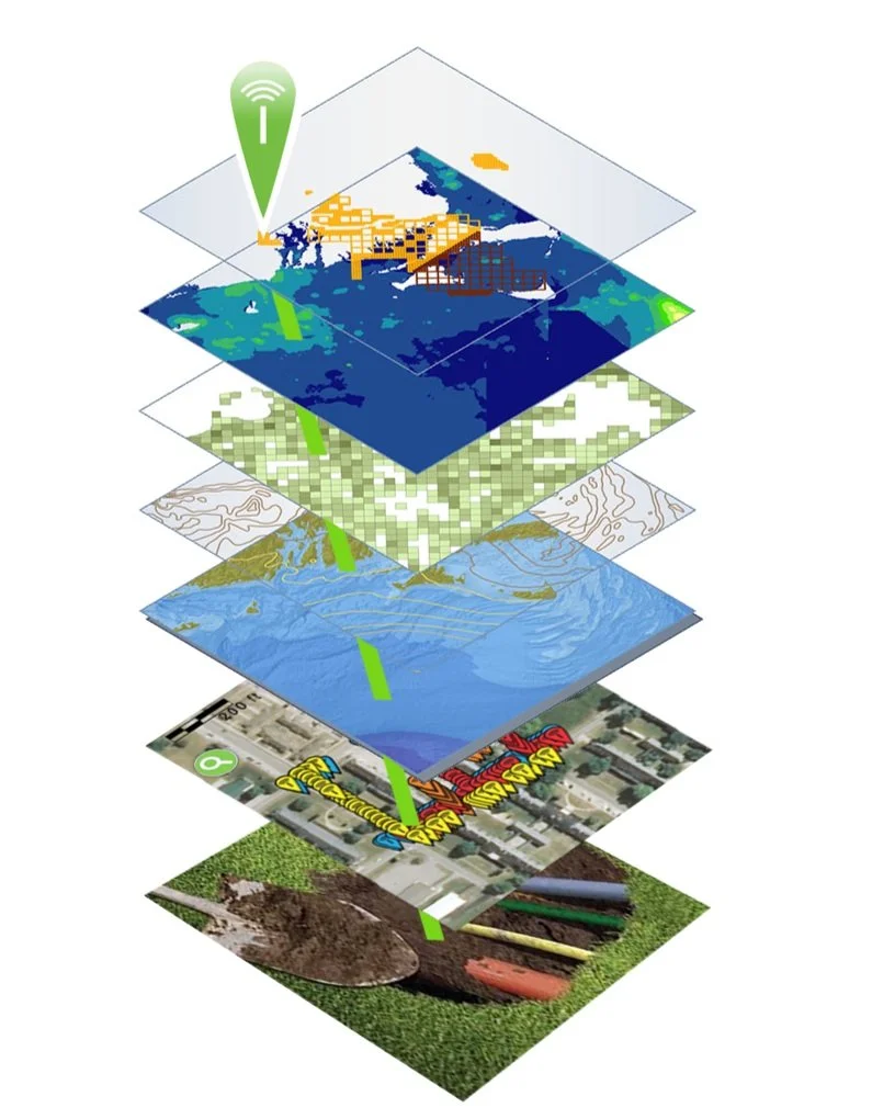
Geographic Information Systems (GIS) are already used extensively by municipalities and utilities across the country. These platforms are ideal for mapping and visualizing underground infrastructure and are already in use by many utilities and municipalities across the country.
Adding processes for mapping underground utilities as they are they are installed (or uncovered by new excavation) can provide highly accurate, shareable maps for every contractor on a construction site. These efforts are already underway. For example, Esri, a global leader in GIS, delivers capabilities designed to make the visualization, identification, mapping and management of underground utilities accessible for all stakeholders. Its ArcGIS platform is ideal for generating accurate visual depictions of location and other data in layers. This platform uses data from a wide range of sources, including field operations. Field workers use cell phones or tablets to collect data in real time as they install underground infrastructure.
To ensure location data is absolutely accurate for future excavations, Esri offers the InfraMarker RFID app that integrates with its Field Maps or Survey123 field data collection software. As utilities are buried (or uncovered during excavation), RFID tags are placed on or near critical points, such as fiber junctions, valves, places where multiple assets converge and so on. Essential data about the asset, its owner and location data are written to each tag for future on site location and verification. This data is linked to ArcGIS via the InfraMarker/data collection apps, providing verified location data of the buried utility while also linking it to critical information about the asset, including video, schematics, maintenance and other data.

What this means is that in the future, when excavation on the same site is required, the exact location, owner and nature of underground assets can be verified on the spot. Buried RFID tags can be read before ground is broken from above using RFID readers connected to the Esri/InfraMarker data collection apps. Above ground RFID tags can also be read with a cell phone held close proximity to the tag.
The data owner can choose to share selected data with other contractors, preventing damage to their critical underground facilities during excavation.
Accurately mapping of underground assets is key to preventing damage. If used consistently, GIS and RFID deliver in-field location verification and identification data that streamline buried asset locating – preventing costly utility strikes and construction delays.
See it for yourself
Berntsen International supports CGA’s mission and will be showing InfraMarker RFID at the upcoming CGA Conference and Expo April 14-18 at the Broadmoor in Colorado Springs, Colorado in booth 322. We look forward to seeing you there!
References:
NP Case Study Minnesota Utilities Mapping (commongroundalliance.com)
https://www.linkedin.com/pulse/striking-balance-unearthing-facts-solutions-utility-line-machuca/
https://www.theutilityexpo.com/news/digging-safely-preventing-underground-utility-stri
https://www.amprobe.com/consequences-of-striking-underground-infrastructure/