
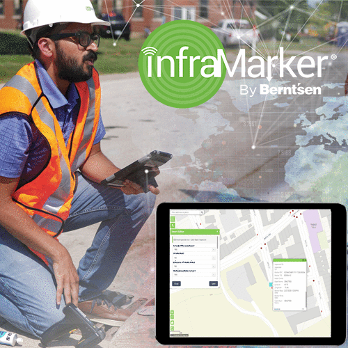
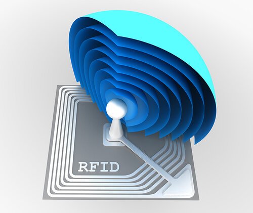
The InfraMarker® RFID App Now Live in the Esri ArcGIS Marketplace
Madison, Wisconsin – March 7, 2022: Berntsen International, Inc., was recognized with the High Potential Award at the 2022 Esri Partner Conference (EPC) held in Palm Springs, California March 5–7, 2022. This award was presented to Berntsen International Inc., for the substantial opportunity for growth represented by its InfraMarker® Connected RFID™ solution that links the power of ArcGIS with RFID asset marking to deliver more accurate and efficient field operations.
MADISON, Wisc., June 23, 2022 - Berntsen International, a leading manufacturer of infrastructure marking products, announces that its InfraMarker RFID App is now live in the Esri ArcGIS Marketplace. The InfraMarker RFID App provides the connection between passive UHF RFID marking technology and Esri’s ArcGIS software. This linking of RFID and GIS with the app enables faster, more reliable asset tracking and management.
Passive UHF RFID is the fastest growing asset identification technology in the world and used to verify, trace, and track products in inventory, retail, manufacturing, utilities, and construction industries. With the InfraMarker RFID app, those RFID-marked products can now be directly integrated with the power of GIS and asset management software.
“ArcGIS is a powerful solution for infrastructure management, made even more valuable when coupled with RFID asset identification technology. We are proud to extend Esri’s ArcGIS software with InfraMarker RFID and provide this additional capability for Esri partners and users”, said Mike Klonsinski, president of Berntsen.
InfraMarker, a division of Berntsen International, is the leader in connected RFID-enabled infrastructure asset marking products and software. The InfraMarker RFID app connects RFID marked products with GIS and Asset Management software while InfraMarker RFID-enabled marking products and equipment are specially designed to work with the app for management of utility infrastructure such as stormwater, gas, electrical and fiber.
The InfraMarker RFID App is available on the ArcGIS Marketplace. The ArcGIS Marketplace is a curated digital geospatial channel of system ready apps, content, solutions, and professional services from Esri’s ecosystem of partners for ArcGIS users to identify and discover additional resources for ArcGIS software.
Link to the Marketplace listing here: InfraMarker RFID App
About Berntsen International, Inc. and its InfraMarker® Solution:
Berntsen International has been a Madison, WI manufacturer of survey and utility marking products since 1972 and a pioneer in developing RFID-GIS connecting solutions under the InfraMarker brand for more than a decade. Berntsen has been an Esri Silver Partner for more than 10 years. Visit Inframarker.com for more information and to purchase an introductory InfraMarker RFID package.
CONTACT:
Kari Campbell, Public Relations, Berntsen International, Inc.
Phone: 608.443.2772
Email: kcampbell@berntsen.com
Berntsen International, Inc. Receives Esri’s High Potential Award for Substantial Opportunities for Growth at the Esri Partner Conference
Madison, Wisconsin – March 7, 2022: Berntsen International, Inc., was recognized with the High Potential Award at the 2022 Esri Partner Conference (EPC) held in Palm Springs, California March 5–7, 2022. This award was presented to Berntsen International Inc., for the substantial opportunity for growth represented by its InfraMarker® Connected RFID™ solution that links the power of ArcGIS with RFID asset marking to deliver more accurate and efficient field operations.
Madison, Wisconsin – March 7, 2022: Berntsen International, Inc., was recognized with the High Potential Award at the 2022 Esri Partner Conference (EPC) held in Palm Springs, California March 5–7, 2022. This award was presented to Berntsen International Inc., for the substantial opportunity for growth represented by its InfraMarker® Connected RFID™ solution that links the power of ArcGIS with RFID asset marking to deliver more accurate and efficient field operations.
RFID is the fastest-growing asset identification technology in the world and is ideal for marking infrastructure products such as valves, splices, poles and more. The InfraMarker RFID app enables a direct connection between ArcGIS mobile solutions and RFID-marked assets. This simple approach improves asset locating and identification, speeds inspection and maintenance workflows, reduces errors, and supports compliance requirements.
Esri is the global leader in location intelligence with a network of over 2,700 partners around the world. The award winners are organizations that have demonstrated innovative and creative ways to solve complex problems by using Esri’s ArcGIS software and those who have done exceptional work in advancing geographic information systems (GIS) technology. Berntsen International, Inc. was one of 26 Esri partners that received an achievement award at the conference.
“Esri congratulates Berntsen International, Inc. on their 2022 EPC award in recognition of their innovative work leveraging ArcGIS software,” said Robert Laudati, Director of Global Partners and Alliances at Esri. “We are proud to partner with Berntsen to foster the use of GIS technology in support of our mutual customers.”
“Berntsen’s partnership with Esri is the cornerstone of advancing a world that uses RFID technology to tie physical field assets to the digital representation of those assets in the GIS,” said Mike Klonsinski, president of Berntsen International, Inc. “This award recognizes the importance of that future as well as InfraMarker’s leadership in providing the software, products, and solutions for a Connected RFID world.”
About Esri
Esri, the global market leader in geographic information system (GIS) software, location intelligence, and mapping, helps customers unlock the full potential of data to improve operational and business results. Founded in 1969 in Redlands, California, USA, Esri software is deployed in more than 350,000 organizations globally and in over 200,000 institutions in the Americas, Asia and the Pacific, Europe, Africa, and the Middle East, including Fortune 500 companies, government agencies, nonprofits, and universities. Esri has regional offices, international distributors, and partners providing local support in over 100 countries on six continents. With its pioneering commitment to geospatial information technology, Esri engineers the most innovative solutions for digital transformation, the Internet of Things (IoT), and advanced analytics. Visit us at esri.com.
About Berntsen International, Inc.
Since 1972, Berntsen International has provided high quality marking products to define the boundaries and infrastructure of the world. Berntsen marking products have been deployed throughout the world and its survey caps and monuments are recognized as the global standard.
Berntsen’s commitment to better infrastructure marking is taken to the next level with its innovative InfraMarker line of software, products, and solutions. The InfraMarker approach enables a connected infrastructure world by linking GIS platforms with RFID asset marking technology. Connected RFID infrastructure improves safety and field operations management for utilities, municipalities, and other organizations desiring better field asset management.
Berntsen is a Silver Partner in the Esri Partner Network, and InfraMarker RFID is an approved ArcGIS System Ready Specialty accessible on Esri's ArcGIS Marketplace.
CONTACT:
Kari Campbell, Public Relations, Berntsen International, Inc.
Phone: 608.443.2772
Email: email@berntsen.com

Blossoming Blooms
Harmful algae blooms (HABs) are occurring more and more frequently in lakes, rivers, streams and coastal areas across the United States. Further, HABs are occurring where they were never found in the past. View a map from the Natural Resources Defense Council that tracks HABs across the United States.
CONTAINING THE THREAT OF HARMFUL ALGAL BLOOMS (HABS) IN URBAN ENVIRONMENTS
Harmful algae blooms (HABs) are occurring more and more frequently in lakes, rivers, streams and coastal areas across the United States. Further, HABs are occurring where they were never found in the past. View a map from the Natural Resources Defense Council that tracks HABs across the United States.
The chart below tracks the number of reports of algal blooms over time up to October 2021.
NUMBER OF HARMFUL ALGAL BLOOMS IN THE U.S. BY YEAR

WHAT IS A HARMFUL ALGAL BLOOM?
An algal bloom is an overgrowth of microscopic algae or algae-like bacteria in fresh, salt or brackish water. Many type of algae or bacteria can produce algal blooms; not all are toxic and not all are harmful. Less than one percent of algal blooms produce toxins; harmful algal blooms (HABs) are those that have negative impacts on humans, marine and freshwater environments and coastal areas.
The most common types of harmful freshwater algal blooms are caused by cyanobacteria. Some types of cyanobacteria can produce dangerous cyanotoxins. Some of these cyanotoxins can attack the liver, kidneys, central nervous systems, skin and lungs, resulting in serious damage or even death.
WHAT CAUSES HARMFUL ALGAL BLOOMS?
HABs can occur naturally, but the increasing prevalence and frequency is caused by:
Nutrient pollution, such as agricultural runoff, wastewater and stormwater runoff (which is increasing due to more frequent severe rainfall events).
Warmer temperatures.
Still water, such as in dams, canals and other man-made waterways.
STORMWATER MANAGEMENT – THE FIRST LINE OF DEFENSE AGAINST HABS
HABs have a significant, yet largely unmeasured economic impact. Looking at just the recreation and tourism industry, a single harmful algal bloom event in a lake in Ohio cost $37-$47 million in lost tourist revenue over two years.*

The reduction of nutrient pollution is the most accessible and effective method of reducing algal blooms in urban areas. It is estimated that 10 trillion gallons of untreated stormwater now flow into our lakes, rivers, streams and coastal areas.
Many municipalities are implementing asset management programs (AMPs) to help quantify and manage their stormwater infrastructure. Because infrastructure was built over a long period of time, it’s likely that documentation fragmented and inaccurate, which makes efficient maintenance very difficult. Actually knowing the location and condition of infrastructure assets goes a long way in creating a proactive plan to inspect, manage and repair existing assets.
SMALL INVESTMENTS IN PROVEN TECHNOLOGY CAN MAKE A BIG DIFFERENCE

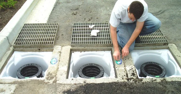
Reading an RFID marker on a catch basin.
Fortunately, cost-effective technology is available to help make efficient asset management available to municipalities. Rather than keeping track of stormwater assets on paper and then digitizing the information, many municipalities have gone digital, using Geographic Information Systems (GIS) to keep track of their catch basins, swales, hydrants and other assets. However, in many cases, even if all the assets are viewable on a GIS system, truly useful data is not.
For example, a single intersection may have literally dozens of manholes, storm drains, catch basins, hydrants and other assets that require regular inspection and maintenance. GIS systems don’t have a way to identify discrete assets in close proximity. That’s where the InfraMarker system comes in. It offers a way to link verified physical location with the digital world using simple, proven technology.
Any asset that is marked with a RFID tag can be linked to unlimited asset information in a GIS using a simple mobile app. Field technicians can verify with certainty where they’re at and then link their maintenance activity with that specific asset – no guesswork or wasted time involved.
Asset managers benefit because they can view all assets online and delve into each specific record to view videos, photos and any other documentation the field tech has attached to the specific tag. An audit trail has been created so asset managers can schedule inspections and maintenance knowing that there will be no confusion or wasted time in the field dealing.
*Estimated Annual Ecomonic Impacts from Harmful Algal Booms (HABs) in the United States, WHOI-2000-11.

811 - CALLING IS A MUST, BUT NOT ENOUGH
A week ago today, National 811 Day was commemorated. It’s a national awareness campaign to highlight the need to call 811 before digging – in our yards or at a construction site. Many organizations in charge of utility assets use this day to promote the importance of calling 811 BEFORE digging. For example, The Southern Gas Company did this great “No Diggity” video to help promote awareness.
A Blog by Emily Pierce, PLS, CFedS
There’s a better way.

A week ago today, National 811 Day was commemorated. This means a lot to me because I know first hand how important it is that people make the 811 call before digging. But I also know that there is a lot more to underground safety than more 811 calls. We need better methods for identifying and validating what is underground.
According to the Pipeline and Hazardous Materials Safety Administration (PHMSA), ruptured gas distribution systems have killed an annual average of 10 people and injured an average of 46 more.[i] Excavation damage has almost always been the cause of ruptures that resulted in fatality, an injury requiring in-patient treatment, or damages more than $50,000.
For firms that are excavating every day, the need to “Know what’s below” is essential for safe operations.

The latest DIRT Report (Damage Information Reporting Tool) shows that damages caused by underground utility strikes are increasing for the fifth consecutive year. In 2019, the cost of this damage was estimated at $30 billion. The most common cause listed for these utility strikes was “failure to notify”, meaning no one called 811 before excavation. But other causes, such as excavation issues and locating issues are also leading causes for damage.
The truth is that we don’t really know how much damage is done by excavation errors. In many sectors, there are no legal requirements for reporting utility strikes. Although a growing number of companies are voluntarily reporting, the data provides a very incomplete picture.

The National Society of Professional Surveyors (NSPS) is working to raise the visibility of the need for accurate geospatial data for infrastructure projects that include transportation, energy, communications, water supply, and other systems. NSPS is one of the thirteen members of the Coalition of Geospatial Organizations (COGO) that seek to speak with one voice on geospatial data and policy issues. This group provides input to the Federal Geographic Data Committee that has developed a National Spatial Data Infrastructure Strategic (NSDI) Plan.
These groups were heavily involved in the Infrastructure Bill working its way through our federal legislative process. They are working to ensure that the federal investment in infrastructure improvements include geospatial data components to increase accuracy and precision in our infrastructure investments, like transportation, high-speed internet, power and gas utilities, rails, and clean water.
Trends toward the adoption of new technologies that help create accurate data to help us “Know what’s below” are strengthening. I know that surveyors are embracing new technologies to that help create underground surveys. Along with GIS, LiDAR and GPR, other tools are making the job of underground surveying much easier.
There’s a better way - connected RFID
For example, over the past year, I’ve been working with a number of utilities who are using Connected RFID to track and manage infrastructure assets. RFID is a key technology that enables direct connection between the real world and the geospatial world.
One of the most persistent and thorniest problems of any kind of geospatial data is accuracy. If the data isn’t spatially accurate, then its usefulness is massively reduced. I know I’m preaching to the choir. We surveyors spend our lives creating and correcting geospatial data and understand the importance of accuracy.
A direct connection between an infrastructure asset and its data is of tremendous value, and that’s exactly what InfraMarker RFID does. It’s pretty simple – an RFID tag is affixed to an asset (above or below ground). Each RFID tag has a unique ID that is linked to that asset’s record in the GIS system using software on a mobile device. Once linked, a field technician can scan a tag and automatically load that asset’s specific record for updating. No need for a line of sight with RFID, so this makes InfraMarker perfect for underground utilities.
More and more, gas, water and telecom utilities are adding InfraMarker RFID to enhance the accuracy of their geospatial data and make life easier for field technicians. As a surveyor, think of how much easier our jobs would be if we could actually scan buried markers and have them identify themselves . . . or use the RFID scanner to identify nearby buried utilities.
The advantage of InfraMarker is the accuracy it delivers to help utilities better manage their infrastructure assets. A value-add is that this data could also help prevent excavation strikes, helping everyone “Know what’s below”.
While we know that 811 has some inefficiencies, it is the best first line of defense for damage prevention for a property owner and the utility. Without proper locating subsurface utilities before excavation, the results can be costly.
Interested? Contact me for more info - info@inframarker.com
[i] https://thestoddardfirm.com/premises-liability/construction-accident-injuries/gas-line/

A DAM-AGING STORMWATER REPORT CARD FROM ASCE
Urban flooding results in more then $9 billion in damages annually, while federal funding to support stormwater maintenance/upgrades averages about $250 million annually. It’s not surprising that stormwater infrastructure is in bad shape and has earned a grade of “D” from the ASCE.
Blog by Tom Hershberger, MS, MBA
Infrastructure is a hot topic now, and it’s long overdue for more than just discussion during National Infrastructure Week.
The American Society of Civil Engineers (ASCE) have been focused on this topic since 1988, producing a regular report card for US infrastructure. At first, there were 12 categories, and with this year’s addition of Stormwater, there are 18 categories.
Urban flooding is problem #1
Urban flooding results in more then $9 billion in damages annually, while federal funding to support stormwater maintenance/upgrades averages about $250 million annually. It’s not surprising that stormwater infrastructure is in bad shape and has earned a grade of “D” from the ASCE.
Stormwater runoff is defined as rain or snowmelt that travels over impervious surfaces or cultivated areas, then is collected and drained into streams, rivers, lakes, bays or oceans. These systems of stormwater conveyance take many forms, from canals, to sewers, detention ponds and constructed wetlands.
In the US, there are approximately:
3.5 million miles of storm sewers
270 million storm drains
2.5 million stormwater treatment assets
Stormwater systems are a mix of publicly-owned (by local, state and the federal government) and privately-owned assets. The EPA is tasked with regulating all of this, but their focus has primarily been on Municipal Separate Storm Sewer Systems, known as MS4s. Because of this, most municipalities have an asset management / maintenance program.
On the other hand, corporate property owners or homeowners associations are not routinely monitored, which leads to deferred maintenance and increases the likelihood of urban flooding and increases the threat of pollution from runoff.
Stormwater conveyance systems have a lifespan of 50-100 years (depending on what materials were used in the original construction, such as reinforced concrete, corrugated metal or PVC). Because most stormwater systems are paid for by local fees or taxes, that often means that maintenance and/or replacement have been postponed, leaving many communities with dangerously outdated stormwater infrastructure.
Even in communities where stormwater systems were constructed more recently (within the past 30 years), it’s likely that they weren’t designed for today’s capacity needs, especially with the growing frequency of high-precipitation events.
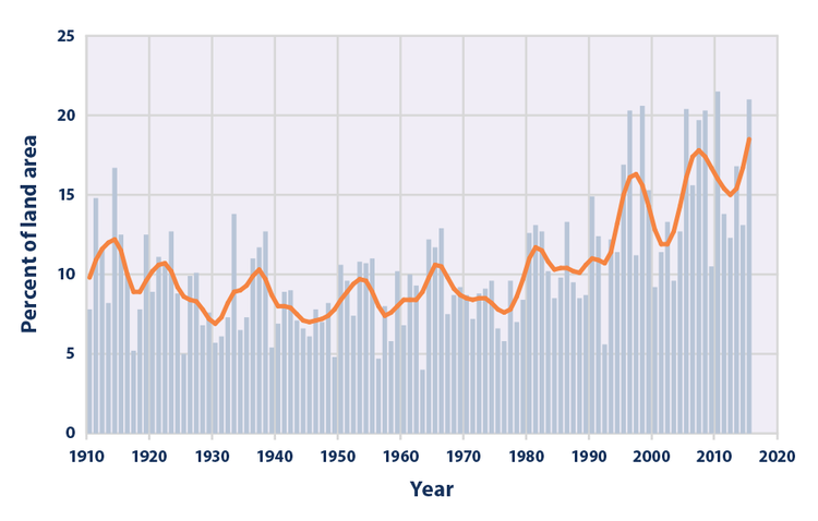
This figure shows the percentage of the land area of the contiguous 48 states where a much greater than normal portion of total annual precipitation has come from extreme single-day precipitation events. The bars represent individual years, while the line is a nine-year weighted average.
Beyond flood mitigation
Stormwater runoff causes lots of problems besides flooding. Every year, an estimated 57 million Americans are sickened by contaminated water in recreational areas. An 2019 analysis of fecal indicator bacteria sampling data from beaches in 29 coastal and Great Lakes states and Puerto Rico, reveals that 386 beaches – nearly one of every eight surveyed – had potentially unsafe levels of pollution on at least 25 percent of the days that sampling took place that year.
Additionally, other types of pollutants flow into our waterways when stormwater is not controlled. For example, the quantity of used oil from a single oil change can pollute up to one million gallons of fresh water. Then there’s all the litter, construction debris, fertilizer, pesticides, road salt, pet waste, etc., that regularly flows into storm sewers. In an up-to-date stormwater system, these pollutants can flow into swayles, rain gardens where they can be held and filtered, instead of flowing directly into a stream, lake or ocean.
It’s vitally important that these systems are brought up-to-date.
Learning to make the most of what we have
Additional money for infrastructure may be on its way, but in the meantime, many municipalities and stormwater management organizations are already executing a plan to be compliant with EPA regulations and plan for the future.
The recommended first step toward improving a stormwater system is to have a comprehensive understanding of the location and condition of all existing stormwater assets. This can be very challenging because oftentimes in municipalities, these records are kept in different departments, housed in different databases or even kept in paper files.
Fortunately, technology can really help with this issue. Geographic Information Systems (GIS) are increasingly being used to manage all types of municipal activities. GIS location-based information is extremely useful in managing stormwater assets spread across a specific geographic area. Today, municipalities are busy creating a digital twin of their existing city, which is a great concept that has real-world benefits but also faces real-world disconnects.

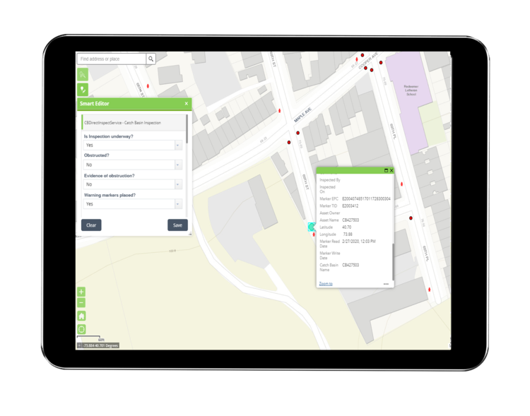
Example images from a geographic information system (GIS) illustrating storm-sewer infrastructure.
One very common disconnect is that the assets a digital map displays are not what maintenance workers find when they come to a job site. For example, they may be tasked to perform an inspection or maintenance on a catch basin located on a specific intersection. They use the GPS to guide them to that location. Upon arrival, they see not one, but four or even eight catch basins in that area. So they have to invest time in working with the office to identify the right basin, or they just pick one and hope it’s the right one.
Unfortunately, guesswork is what the GIS digital twin was supposed to eliminate.
There’s a simple solution that can permanently resolve that issue, while simplifying field documentation. It involves marking assets with an RFID tag, then connecting those tags to their records in the GIS using a standard mobile device.
InfraMarker connected RFID makes all the difference
When marked with RFID tags, field workers no longer need to guess which asset to work on. They can simply have assets identify themselves with a quick read of the RFID tag. Once they identify the asset they need to work on, the right form will pop up and they can complete the work and move on.
InfraMarker RFID-enabled markers directly connect the physical and digital worlds in a way that delivers fast, accurate and auditable asset management. This approach fits into existing field workflows while leveraging existing GIS/Asset Management platforms. InfraMarker connects specific infrastructure assets to their unique digital records, providing accurate, auditable and actionable data to asset managers, often in real time.
RFID-enabled asset management not only ensures that the digital twin is accurate, it generates an audit trail that meets the EPA regulations for compliance.
This simple solution is now being used for all kinds of infrastructure assets across the country, including municipal stormwater assets.
See a quick video of how InfraMarker Connected RFID works to mark and manage stormwater assets here.
To learn more, contact us!.

HOW UNDERGROUND RFID MARKING IS CHANGING THE UTILITIES INDUSTRY
You would think that with all of the technology available today, we’d be able to see what’s underground almost as well as we see what’s above ground. Unfortunately, that’s not the case - underground utility locating remains an issue.
You would think that with all of the technology available today, we’d be able to see what’s underground almost as well as we see what’s above ground. Unfortunately, that’s not the case - underground utility locating remains an issue.

Today, excavators rely on locators to come and find each utility and mark it with a flag before they dig – at least most of the time. In 2018, the single most frequent reason for underground utilities being mistakenly hit during excavation was “Notification NOT made” – meaning that locators were not used before excavation began.
However, if locators are used, it doesn’t mean that they provide exact information – the same report states that 24 percent of accidental utility strikes were due to Locating Issues.
RFID to the rescue
A reliable way to locate buried utilities and instantly know key information about that utility already exists -- based on proven RFID technology. Radio Frequency Identification has been used for years to track items without having to visually confirm them – typical uses are the toll-booth passes that are read remotely when we pass through a toll, or markers on library books that are scanned when we check them out.
RFID tags are ideal for underground utility marking because they are passive (don’t require a battery), have a unique ID as well as a small amount of memory that can contain data such as the utility type and owner. They are durable and can include a magnet to increase the precision of underground locating. Today there is a solution based on RFID markers that is already being used by some utilities.
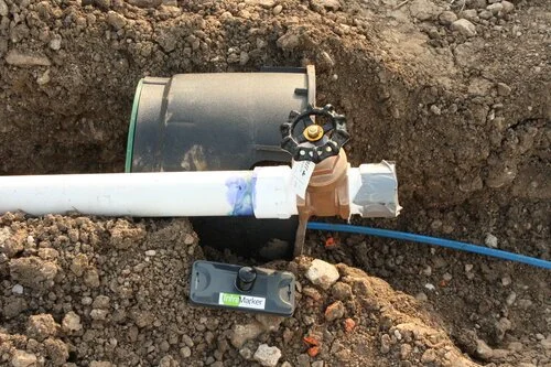
This system is called InfraMarker®, and it’s designed to provide accurate information about assets, below or even above ground. InfraMarker RFID tags are placed on or near the asset. Once accessed with an RFID reader, the latitude, longitude, and unique ID are written to the tag. Then additional information, such as the type of asset and owner are added through software on a smart phone connected to the reader via Bluetooth.
InfraMarker RFID marker and water utility before burial.
Imagine the time and money that could be saved if underground utilities were marked with RFID tags. Excavators could precisely locate underground utilities, and even know what type(s) of utility was below.
Connected infrastructure
With millions of miles of underground piping across the United States, it stands to reason that identifying the unique characteristics of a single asset may be a challenge.
That’s where connected infrastructure can make a huge difference. Asset management software that is now used by many municipalities and utilities can pull the data from each RFID marker and associate that with data in the application – and plot this on a digital map. This data can be shared between utilities, so that location information of water lines, gas lines, telecom lines and fiber optic cables could be shared in a common file format.
Not only would this save time for utilities, it would prevent the estimated $50 billion annual cost of excavation utility strikes.
Contact us to set up a demo to see how the simple, easy-to-use and setup InfraMarker system can save time, money and provide the data you need with the accuracy you require.

STORMWATER UTILITIES FACE ANOTHER TOUGH SPRING
The NOAA 2020 precipitation outlook indicates a high probability of above normal seasonal precipitation amounts from the Mississippi Valley to the East Coast.
The spring of 2019 brought devastating flooding across large swaths of the United States, from the South to the Northeast. Stormwater utilities still dealing with the aftermath of 2019 now face forecasts of another very wet spring.
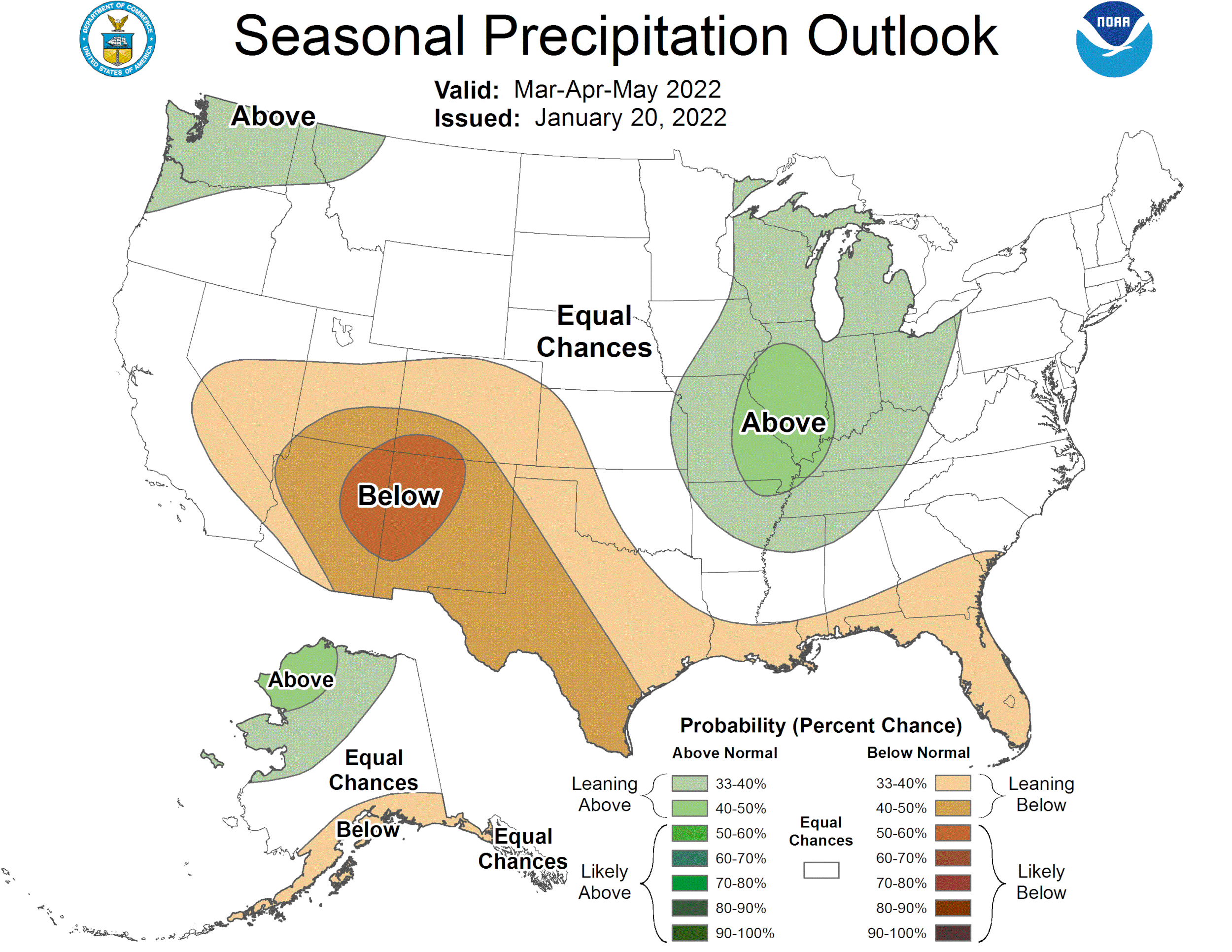
NOAA 2020 THREE MONTH OUTLOOK
The NOAA 2020 precipitation outlook indicates a high probability of above normal seasonal precipitation amounts from the Mississippi Valley to the East Coast. The graphic depicts forecasts from April - June 2020.
Excessive precipitation, along with the generally poor condition of most of the stormwater infrastructure in the US means that capacity to effectively channel stormwater will be stressed during periods of high local precipitation.
Asset Management Programs help utilities manage their stormwater assets
In a recent national survey of municipal separate storm sewer system (MS4) permittees, respondents ranked lack of funding or availability of capital, aging infrastructure, and increasing or expanding regulations as their most important stormwater program challenges.

Clearly, existing stormwater infrastructure must perform optimally at the outer limit of its capacity in order to control flooding. To achieve this peak performance, all of the assets that make up a stormwater utility must be in good repair.
The Environmental Protection Agency (EPA) has encouraged stormwater utilities to develop and implement Asset Management Programs that include using Asset Management software to help manage their assets.
Asset management software is a powerful tool to help utilities gather the data necessary to meet regulatory requirements and drive decision-making for future infrastructure development. The work involved in implementing Asset Management Software (AMS) within utilities is daunting. However, the return on that investment results in the reduction/stabilization of facility operating, maintenance, and renewal costs. Studies show that this savings is substantial over time.
Step-by-step

One of the first steps in developing an asset management program is creating an inventory of assets and scoring those assets related to their condition. Asset Management Software helps this process by digitizing information and tying it to a Geographic Information System (GIS) that visually depicts the location and type of asset. When maintenance and inspection forms are also tied to the asset, the whole process of inspection and maintenance can be streamlined.
Disconnect in the field
Unfortunately, the usefulness of asset management software doesn’t always translate to usefulness in the field. Often, field workers have incompatible software (or have to translate spreadsheets or paper worksheets into data in the AMS). Even if the field workers have direct access to the AMS, there is often a disconnect between the depiction of an asset location on a digital map and the physical location of a specific asset in the field. This results in wasted time and confusion in the field to locate and record maintenance / inspection activities.
Fortunately, a simple and cost-effective solution exists. RFID technology has been used for years to track and manage inventory has been adapted to link the physical location to the digital location.
Simple technology connects the digital to the physical

Each asset is marked with an RFID-enabled tag which is read into the AMS and linked to management / inspection records. This simple tool takes the guesswork out of locating and verifying assets while instantly producing an auditable inspection / maintenance trail in the asset management system.
Certified RFID-enabled asset markers are available in many configurations, including curb markers, manhole cover markers, hydrant markers and a range of other durable configurations, including underground markers. RFID markers are passive, don’t require batteries and are extremely durable.
Stormwater utilities across the country are deploying this system, called InfraMarker®, to extend the capabilities of their asset management/GIS systems to the field.
Call us today to schedule a demo of the InfraMarker RFID solution.