
Key Trends in 2024
The “Fourth Industrial Revolution” is well underway. Back in 2011, economist Klaus Schwab coined the term to refer to the rapid digitization and accessibility of technologies that spark a global shift in processes – in everything from how we communicate to how businesses and governments are managed.

The “Fourth Industrial Revolution” is well underway. Back in 2011, economist Klaus Schwab coined the term to refer to the rapid digitization and accessibility of technologies that spark a global shift in processes – in everything from how we communicate to how businesses and governments are managed[1].


Drone image by Florian Pircher from Pixabay

Building information model of a mechanical room developed from lidar data (image provided by Yelda Turkan, OSU College of Engineering).
More a decade later, this revolution is accelerating, driven by the widespread use of cloud computing, “big data”, virtual reality and artificial intelligence (AI). These “disruptive technologies[2]” are fundamentally changing our lives and how we do our jobs. All industries, including surveying and civil engineering, are leveraging these new technologies to automate tasks, increase precision and generate more useful data.
Integration of 3D Laser Scanning Technology (LiDAR)
3D laser scanning traces back to the early 1960s when researchers experimented with laser technology to measure distances and create 3D representations of objects. The first practical applications of laser scanning emerged in the 1970s, in the field of surveying and topographic mapping. However, 3D laser scanning didn’t become useful until advancements in computing power and data processing capabilities were integrated with portable scanning technology. Today, surveyors can combine 3D scanners with their total stations to measure distances and create accurate three-dimensional representations of the surveyed area. The use of 3D laser scanning enhances data collection speed, accuracy, and enables more comprehensive visualization and analysis[3]. Berntsen offers a line of laser targets designed to work with these advanced systems – enhancing accuracy and ensuring repeatability.Drones
Drones equipped with high-resolution cameras and LiDAR sensors capture imagery and terrain data, allowing surveyors to obtain valuable insights for mapping, topographic surveys, and volumetric calculations. This technology makes it possible to survey inaccessible areas, reducing field time and increasing the efficiency of data collection and processing[3]. Of course, having accurate reference points is key to successful aerial surveying – see how Berntsen’s drone targets can work for you.Building Information Modeling (BIM)
BIM uses a range of technologies to create a digital representation of a structure or infrastructure project, integrating survey data with architectural, engineering, and construction information. Surveyors contribute crucial geospatial data to BIM models, facilitating clash detection, accurate quantity take-offs, and construction coordination. BIM enhances collaboration among project stakeholders, reduces errors, and enhances overall project efficiency[3]. Berntsen helps surveyors ensure BIM data precision with its line of smart targets and reflectors.

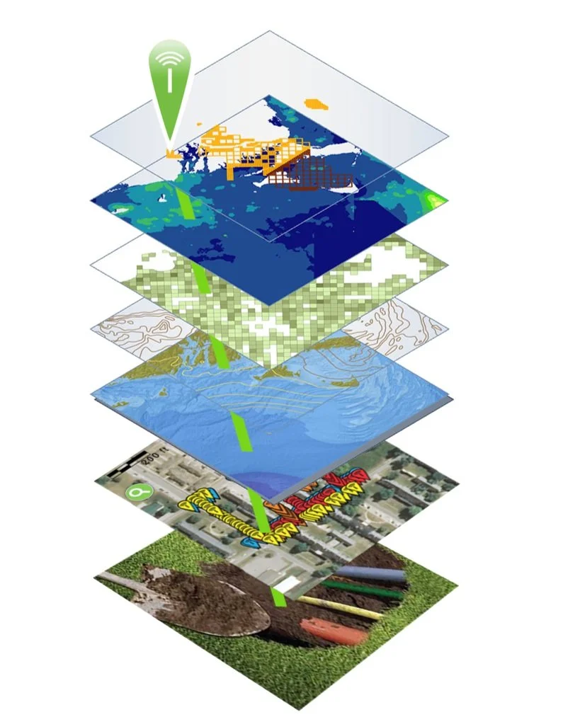
Layers in Geographic Information Systems, augmented with RFID
Augmented Reality (AR) and Virtual Reality (VR) Applications
Augmented Reality (AR) and Virtual Reality (VR) technologies are finding their way into land surveying practices, offering immersive experiences and enhanced visualization. AR and VR applications enable surveyors to overlay survey data onto the real world or create virtual environments for project planning and simulation. These technologies aid in communication, decision-making, and public engagement, providing stakeholders with a better understanding of the surveyed area and proposed designs[3]. These visualizations are extremely precise when surveying measurements include the use of high-quality prisms that help ensure accuracy – available from Berntsen.Geographic Information Systems (GIS)
Cloud-based Geographic Information Systems provide centralized storage, access, and analysis of map-based survey data. GIS is another technology that was first developed in the 1960s using existing spatial analysis and visualization methods, combined with computing power, to identify and manage land characteristics and use over large areas. Soon the usefulness of a spatially based approach to data visualization and analysis was applied to a vast range of functions. Today, GIS is becoming more and more powerful through the integration of other technologies, including Radio Frequency Identification (RFID) and AI.
Radio Frequency Identification (RFID)
As data visualization gets better and better, it becomes increasingly important to ensure that the data itself is precise. That’s where RFID comes in. RFID literally ties the physical to the digital, authenticating any marked asset at its physical location. An RFID tag, placed on anything anywhere can be instantly read on-site, activating its full data record from the GIS or BIM platform. Today, the combination of GIS and RFID is used to verify and manage a vast array of items – from infrastructure assets to dinosaur bones. Berntsen offers a full range of RFID tags and software that integrate with GIS, BIM and other platforms to provide instant authentication to any asset, anywhere.Artificial Intelligence (AI)
AI is set to bring another wave of change to the way we live. AI is the ability of a machine to display human-like capabilities such as reasoning, learning, planning and creativity. AI enables technical systems to perceive their environment, deal with what they perceive, solve problems and act to achieve a specific goal. The computer receives data - already prepared or gathered through its own sensors such as a camera - processes it and responds. AI systems can adapt their behavior to a certain degree by analyzing the effects of previous actions and working autonomously[4].
Combining AI with geographic information system (GIS) and RFID technology delivers real-world context and authentication to operations.

According to Esri, close observers of AI have noted that as an analytic tool, much of what it accomplishes falls into three main categories in which AI and location intelligence fit seamlessly:
Automate tasks and repeat them quickly at scale. A utility company can use AI and location intelligence, along with drone [and RFID] technology, to examine utility poles and wires, determining where telltale signs suggest repairs are necessary.
Look at past patterns to make predictions. A logistics or manufacturing company can use AI and location intelligence to optimize supply chains, considering such disparate data as weather forecasts, the likelihood of ship and rail traffic backup, and how many left-hand turns there are on driving routes.
Search for patterns hidden in large amounts of data[5].
A key point

In the midst of the Fourth Industrial Revolution, it’s important to remember that there are some things that data, computing and visualization can’t do. Every person exists in the physical world, not as a consumer or data point, but as living, breathing, thinking being.
At Berntsen, we put people first, by caring for our customers, anticipating future needs, and providing personal support, from live webinars to one-on-one meetings. We all want to leave our mark, and Berntsen is here to help.
References:
[3] https://www.pointscan.co.uk/the-evolution-of-3d-laser-scanning/
[5] https://www.esri.com/content/dam/esrisites/en-us/media/ebooks/artificial-intelligence.pdf
Background:
https://www.landform-surveys.co.uk/news/thoughts/ai-surveying/
https://www.linkedin.com/pulse/emerging-trends-land-surveying-practices-primaverse/

Public Works — Key to civilization
Public works have been around ever since people found ways to ensure a reliable source of water for their crops. In 4000 BC, the ancient Sumerians created a successful irrigation system that watered fields between the Tigris and Euphrates Rivers.
What does the term “Public Works” mean? It’s one of those terms that are so broad that it almost defies definition.
The American Public Works Association (APWA) says “Because of the multi-faceted, ever-evolving nature of public works, we may never arrive at a final definition but, for now, the following definition seems appropriate: Public works is the combination of physical assets, management practices, policies, and personnel necessary for government to provide and sustain structures and services essential to the welfare and acceptable quality of life for its citizens.”

Haghe, L. & Roberts, D. (1849) Excavated mansions of Petra, Petra, March 7. Extinct City Petra, 1849. [Published] [Photograph] Retrieved from the Library of Congress.
A Long History

By Saqib Qayyum - Own work, CC BY-SA 3.0,
A 2.4m deep, 12m long, and 7m wide pool known as "The Great Bath" is located at the centre of the Citadel, is made of fine baked waterproof mud bricks and a thick layer of bitumen. It is the earliest public water tank of the ancient world. Adjacent to it are a well that was used to supply water to the bath.
Public works have been around ever since people found ways to ensure a reliable source of water for their crops. In 4000 BC, the ancient Sumerians created a successful irrigation system that watered fields between the Tigris and Euphrates Rivers. In Mohenjo‐Daro, a major urban center of the Indus Civilization (India), a sophisticated system for supplying water and expelling sewage dates back to the mid-third millennium BC. Water came from more than 700 wells and supplied not only domestic demands but also a system of private baths and a Great Bath for public use. Drains and sewers were carefully constructed to facilitate the removal of waste.[1]
Beginning in 586 BC, the Nabataeans, who lived in northern Arabia and the southern Levant, created a sophisticated water collection system which allowed them to build an impressive trade empire in the heart of arid Arabia.[2]
Of course, everyone knows about the Romans, who constructed roads, harbor works, aqueducts, temples, forums, town halls, arenas, baths, and sewers – many of which are still seen today, more than 2,000 years later. These public works were designed to stabilize and strengthen the empire and make the lives of Roman citizens better.
Recent history

Segovia--El Puente. Segovia Spain, None. [Between 1900 and 1910] [Photograph] Retrieved from the Library of Congress.
Fast forward a couple thousand years, and public works became key to stabilizing the American economy during a time of crisis. Back in 1933, the federal government undertook a massive public works effort to counteract the devastating effects of the Great Depression. For a decade, the federal government poured $3.8 billion through the Public Works Administration (PWA) into projects that radically transformed the country’s infrastructure. Prominent projects included New York’s Triborough Bridge, Grand Coulee Dam, the San Francisco Mint, Reagan National Airport and Key West’s Overseas Highway.[3]
Later, in 1935, President Roosevelt used an executive order to create the Works Progress Administration (WPA). At the time, unemployment was holding steady at 20 percent, and the economy needed a serious boost. The WPA employed mostly unskilled men to carry out public works infrastructure projects. They built more than 4,000 new school buildings, erected 130 new hospitals, laid roughly 9,000 miles of storm drains and sewer lines, built 29,000 new bridges, constructed 150 new airfields, paved or repaired 280,000 miles of roads and planted 24 million trees to alleviate loss of topsoil during the Dust Bowl. Over the course of 10 years, the WPA put 8.5 million people to work, strengthening communities and laying the groundwork for the largest industrial expansion in history -- the wartime economy of 1945.
The Infrastructure Investment and Jobs Act

Grand Coulee dam construction. , None. [Between 1936 and 1946] [Photograph] Retrieved from the Library of Congress.
Today, the country is in the midst of another massive public works investment. The Infrastructure Investment and Jobs Act (IIJA) was signed into law on November 15, 2021. The IIJA is an historic investment in our nation’s infrastructure: $1.2 trillion over five years, including $550 billion in new federal spending, including --
passenger and freight rail;
highway and pedestrian safety;
public transit;
broadband;
ports and waterways;
airports;
water infrastructure;
power and grid reliability and resiliency;
resiliency, including funding for coastal resiliency, ecosystem restoration, and weatherization;
clean school buses and ferries;
electric vehicle charging;
addressing legacy pollution by cleaning up Brownfield and Superfund sites and reclaiming abandoned mines; and
Western Water Infrastructure[4]
The American Public Works Association (APWA)

The APWA is an organization that was founded to help public works professionals improve their skills, share information and work together to find the best ways to help their communities. Along with comprehensive training programs and other resources, the APWA helps its members learn about and apply for funds provided by the Infrastructure Investment and Jobs Act.
Each year, the APWA organizes a conference and exposition to help keep its members informed. This year’s conference, held in San Diego, includes 125 technical and professional development sessions using the latest learning models: classroom, interactive, and "live" learning labs. Additionally, more than 400 companies will be exhibiting the latest technology – including Berntsen International’s InfraMarker Connected RFID in booth 1939.
InfraMarker is key to smooth operations
Today, public works is more complex than ever. Even in small cities, more and more organizations are relying on the power of GIS to help manage their assets and streamline operations. InfraMarker RFID is designed to leverage the power of GIS to accurately mark and manage any type of asset - directly from the asset point itself. Each passive RFID marker identifies the asset, connecting to GIS with a simple scan, providing verified asset identity and launching the the associated workflow. This instant asset confirmation of ]identity removes guess-work from field maintenance and speeds routine inspection and maintenance with accurate documentation.
We invite all public works professionals who manage infrastructure assets to see how InfraMarker RFID can improve asset management by providing verified field asset information that links to any GIS system. Sign up here to chat with Brent Sherman, our Sales Manager for a live demo of how InfraMarker can work for you at the APWA Conference, booth 1939, August 27-29.
See how it works:

References:
[2] https://www.ancient-origins.net/artifacts-ancient-technology/nabateans-002193
[3] https://livingnewdeal.org/glossary/public-works-administration-pwa-1933-1943/
Sources:
https://livingnewdeal.org/glossary/public-works-administration-pwa-1933-1943/
http://www.waterencyclopedia.com/Tw-Z/Water-works-Ancient.html#ixzz89u0Sv4uO

InfraMarker Brings RFID Power to Esri Field Operation Applications
Berntsen International, a leading manufacturer of infrastructure marking products, announces that its InfraMarker RFID app is now fully integrated with Esri’s ArcGIS Survey123 and ArcGIS Field Maps mobile applications.
MADISON, Wisc., July 3, 2023 - Berntsen International, a leading manufacturer of infrastructure marking products, announces that its InfraMarker RFID app is now fully integrated with Esri’s ArcGIS Survey123 and ArcGIS Field Maps mobile applications.
Berntsen’s InfraMarker app connects passive UHF RFID – the fastest growing asset identification technology in the world, with Esri’s ArcGIS, the global market leader in geographic information system (GIS) software. The InfraMarker app enhances Esri’s field data collection tools with the ability to read RFID tag information, write data to a RFID tag, associate the RFID serial number with the asset record in the GIS database, and launch inspection and management forms with a RFID interrogation.
“We are proud to bring RFID – the serial number of IoT – to Esri customers across the globe. We are confident that infrastructure managers in utilities, public works, and construction will realize speed, reliability, and cost benefits with InfraMarker RFID,” said Mike Klonsinski, president of Berntsen.
InfraMarker, a division of Berntsen International, is the leader in connected RFID-enabled infrastructure asset marking products and software. The InfraMarker line includes rugged RFID-enabled marking products, RFID readers and accessories, and RFID-connecting software to enhance GIS and asset management platforms.
About Berntsen International, Inc.
Since 1972, Berntsen International has provided high quality marking products to define the boundaries and infrastructure of the world. Berntsen marking products have been deployed throughout the world and its survey caps and monuments are recognized as the global standard.
Berntsen’s commitment to better infrastructure marking is taken to the next level with its innovative InfraMarker line of software, products, and solutions. The InfraMarker approach enables a connected infrastructure world by linking GIS platforms with RFID asset marking technology. Connected RFID infrastructure improves safety and field operations management for utilities, municipalities, and other organizations desiring better field asset management.
Berntsen is a Silver Partner in the Esri Partner Network, and InfraMarker RFID is an approved ArcGIS System Ready Specialty accessible on Esri's ArcGIS Marketplace. Visit Inframarker.com for more information and to purchase an introductory InfraMarker RFID package.

RFID - the technology that keeps on giving
We’ve all heard of RFID, a technology that’s been around since the 1930s. Did you know that it’s now one of the fastest-growing technologies in the world?
We’ve all heard of RFID, a technology that’s been around since the 1930s. Did you know that it’s now one of the fastest-growing technologies in the world?
Originally discovered during the development of radar, Radio Frequency Identification (RFID) has proven useful in all kinds of applications, from tracking library books to identifying lost pets to providing visibility into complex supply chains.
The technology is simple and versatile, consisting of a tiny RFID chip/antenna and a RFID reader that interrogates the chip via radio waves. No line of sight is required, and the tiny chips don’t require batteries – the power comes from the RFID reader.
Exponential RFID Market Growth

According to a presentation at the recent RFID Journal Live Conference (May 9-11, 2023), the RFID tag market is growing exponentially. This vibrant market growth will continue as RFID is integrated into more and more systems, including Geographic Information Systems, robotics and more.
The lasting impact of one person on the industry
Early on, in 2002, a reporter for Information Week realized the potential of the fledgling RFID market. About that time, manufacturing companies were trying to get a handle on how to prevent pervasive problems with inventory management and managing shipping information. RFID was one of the many technologies that was being tested to help resolve these problems. The reporter, Mark Roberti, focused his investigative skills on learning all he could about this fledgling technology. Little did he know that the result of his efforts would create a new career and an industry powerhouse.
Soon, Roberti created a website just to post his RFID articles, but it wasn’t until a reader asked about a subscription to the website that he realized he could make money by sharing his fascination with RFID. By 2003, Roberti was organizing annual conferences and online events. In 2007, his efforts received an unexpected boost by a corporate mandate by Walmart – that all suppliers must begin using RFID tags to mark their products. Of course, this mandate resulted in a rush of interest in RFID, as well as a lot of pushback from suppliers. More importantly, a patent holder for RFID technology began to enforce its patents. This stymied the corporate investment in RFID -- until Roberti stepped in and helped the industry manage licensing issues.
Before the advent of social media and e-commerce, the RFID industry found itself the focus of misinformation. In 2008, some consumer organizations began boycotting clothing with embedded RFID tags, erroneously believing that the tags would enable companies to spy on their customers. These groups got a lot of media attention, but the inherent versatility of RFID enabled manufacturers to resolve the issue (if not the misinformation). The RFID tags were simply placed on removable tags.
Growing with RFID

Back in 2010, Berntsen recognized the potential RFID could have on marking and managing underground infrastructure. Leveraging its broad expertise in infrastructure marking, the company began developing a system based on RFID technology that enabled users to digitally locate and manage their infrastructure assets. Unlike mapping or GIS platforms, an RFID-based system starts with the physical asset marked with an RFID tag. A simple scan of the tag verifies the asset’s identity and ties it to its specific digital record in a corresponding digital platform. RFID alone can provide this two-factor verification of any asset – a benefit especially relevant for buried infrastructure assets.
Today, Berntsen’s InfraMarker Connected RFID is leveraged by Esri to provide RFID verification to its customers that rely on ArcGIS to manage their assets. More and more organizations are benefitting from the versatility and security of InfraMarker RFID.

It’s GIS Day!
Most people don’t really think about how geographic information provides the framework for our entire existence. We exist as living organisms in time and space. Our minds may be occupied with far-way thoughts, but our memories are inextricably tied to the place where they were created. As long as we live and breathe, we always have a location.
Blog by Emily Pierce, PLS, CFedS

Most people don’t really think about how geographic information provides the framework for our entire existence. We exist as living organisms in time and space. Our minds may be occupied with far-way thoughts, but our memories are inextricably tied to the place where they were created. As long as we live and breathe, we always have a location. Shakespeare’s Hamlet said “To be or not to be, that is the question.” Surveyors say, “To be is to occupy a position relative to two axes.”
Surveyors are trained to understand the implications of geography and location differently than most people. Precision is applied to location and this information has been the basis for civilizations for thousands of years. I’ve written about ancient surveying instruments in previous blogs: Ancient Egyptian Surveying and Ancient Roman Surveying.
Today, geographic information is more important than ever and is being used in ways that were previously unimaginable. As a surveyor, I had the opportunity to work with Geographic Information Systems (GIS) early on, mainly by being the boots on the ground that provided accurate geographic data that was subsequently used in GIS. We provided accurate survey-grade locations on US Public Land Survey corners (section and quarter-section corners) to be utilized into a county tax parcel database. This not only helped improve how the county taxed its citizens, it also helped citizens with land development, taking into account appropriate building sites, flood zones, wetland preservation, general zoning requirements, just to name a few. Beyond that, the GIS also is used for school and voting districts, changes in municipal boundaries and incorporations, addressing, and emergency response management.
Nothing stays the dame
Change has accelerated quickly in the years since I started working with GIS, as evidenced by a 2009 article entitled the “Top Five Benefits of GIS”, with number one benefit being cost savings from greater efficiency using location-based data.
The example cited was Sears, which was able to use GIS to reduce the time it took for dispatchers to create routes for their home delivery trucks by 75%. I’m sure that was a huge savings, but unfortunately for Sears, Amazon was already taking over on every front. By 2021, the Sears footprint had shrunk from 3,862 stores in 2009 to just 19 stores and a website.
Route optimization is only one of the thousands of applications of GIS technology. From precision farming to spatial econometrics (the intersection of spatial analysis with economics) to creating ultra-precise road maps to facilitate autonomous vehicles. Check out the 1,000 Uses of GIS for a glimpse into the future.
When researching this blog, I learned about a project where Toyota is using a platform that gathers crowd-sourced data from vehicle cameras and combines it with high-precision GPS and GIS to create precise and up-to-date road information. This information will be used for autonomous driving in the future, or probably already is!
What?!
Interestingly, a whole new industry is being created around monetizing the vast amount of data that is generated from vehicles. McKinsey estimates the market for this information might add up to $450-650 billion by 2030. I wish there was some way I could get a cut of these billions!
You may not even realize that the navigation systems in your vehicles are GIS. I’m partial to the Waze app. I love how they incorporate real-time data on reported crashes, speed traps and even roadkill, (important to know, because we have lots of moose and deer up here)! All this can be narrated by people from Dexter on Showtime to PAW Patrol on Nickelodeon.
Other GIS uses

Pretty much everyone knows about the Johns-Hopkins COVID map but did you know that there’s a HealthMap that maps reports the location of all kinds of diseases? For example, in the past month, Legionnaires’ Disease was found in three locations in the U.S. Definitely worth looking at before traveling. NASA is also providing satellite data to cancer researchers to help pinpoint the types of human activity that lead to cancer in geographic areas. The Landsat Program is the longest continuous space-based record of Earth’s land in existence.
As you know, I’m a history buff, and I really like the ArcGIS Online Historical Maps. It makes all the USGS topographical maps accessible. All you need to do is find a place, and any maps that USGS has on it over time will be available. I just downloaded this map form 1890 of New Orleans.
I could go on and on, but I invite you to check out the many ways GIS is being used today.
I know in the past, many surveyors thought that GIS was going to obsolete the profession, but that is definitely not the case. We still need boots in the field tying the data in digital maps to real places in the real world. I’m personally involved in introducing a product that does just that, using RFID to literally tie the physical to the digital. Check it out at inframarker.com. It’s a great product with as many applications as GIS itself.
Emily Pierce is a surveyor and Berntsen’s Business Development Manager. Learn more - email: info@inframarker.com