
Federal agencies get the job done
For more than 50 years, Berntsen has worked alongside federal agencies to provide useful and quality products. From monuments that can be set in wetlands to RFID markers that integrate with Geographic Information Systems (GIS), federal agencies rely on Berntsen to deliver quality products that help them fulfill their missions.
For more than 50 years, Berntsen has worked alongside federal agencies to provide useful and quality products. From monuments that can be set in wetlands to RFID markers that integrate with Geographic Information Systems (GIS), federal agencies rely on Berntsen to deliver quality products that help them fulfill their missions.
See us at booth 830 at the Esri FedGIS Conference on February 13-14, 2024
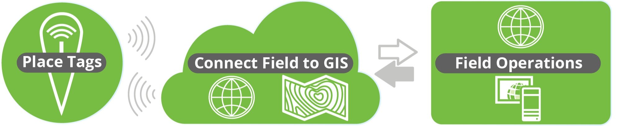
In partnership with Esri, Berntsen is looking forward to demonstrating how InfraMarker RFID can help federal agencies better manage their diverse assets at the upcoming Esri FedGIS Conference. Stop by booth 830 to see how the InfraMarker RFID App for ArcGIS can help you identify, verify and update data for any type of asset in the field with a simple scan. Anything (even underground) that can be marked with an RFID tag can connect to ArcGIS for accurate identification and management. We look forward to seeing you there!
Federal Agencies – partnering with industry to get the job done
Federal agencies are key to maintaining a safe, stable, and thriving nation. From the Department of Defense, that protects Americans at home and abroad, to the Department of Interior that manages America’s vast public lands, to NASA, tasked with exploring the unknown for all the citizens of our planet, federal agencies provide the structure and do the work that makes our country thrive.
One thing these agencies have in common is that they manage many types of assets across vast spaces. From ensuring that gas pipelines are built and operated safely, to marking out trails in national parks, to building dams, highways and runways, these agencies rely on the private sector for products and technologies that help get more done with fewer resources.
Since the foundation of our country, federal agencies have quietly been getting the job done, ensuring stability and growth. This vital structure didn’t happen overnight, and it’s interesting to see the evolution of how these agencies developed.
Department of Defense (DOD)
The DOD is America's largest government agency, with more than 2,870,235 employees and service members. Tracing its roots back to pre-Revolutionary times, the department has evolved with our nation.
The Army, Navy, and Marine Corps were established in 1775, to support the American Revolution. In 1789, Congress created the War Department, responsible for both the Army and Navy until the founding of a separate Department of the Navy in 1798. After World War II, the War Department was reorganized and by 1949, the command structure was unified, and the Department of Defense was created.
Today, the DOD has four branches (Army, Navy, Air Force, and Coast Guard) with the Marines organized under the Navy, and the new Space Force organized under the Air Force. The branches are made up of 34 agencies, including the National Geospatial-Intelligence Agency; and divisions including the US Army Corps of Engineers. Additionally, two organizations are staffed with uniformed service members but don’t report to the Secretary of Defense. These include the Public Health Service Corps (reporting to the Surgeon General who reports to the Assistant Secretary of Health in the Health and Human Services Department) and the National Oceanic and Atmospheric Administration, (NOAA), reporting to the Secretary of Commerce[1]. Interestingly, the NOAA includes the National Geodetic Survey, our oldest scientific agency. In 1807, President Thomas Jefferson founded the U.S. Coast and Geodetic Survey (as the Survey of the Coast) to provide nautical charts to the maritime community for safe passage into American ports and along our extensive coastline[2].
Berntsen has been serving the DOD for decades. In fact, it was a request from the DOD that sparked a new way of creating survey markers.

The first logo marker in cast aluminum.
Back in the late 1970s, the DOD asked Berntsen if the company could create survey disks for a project in Saudi Arabia. The catch was that the disks needed to include Arabic text and the country’s coat of arms -- a palm tree and crossed swords. Back then, the lettering on survey disks was created using zinc letters glued to a wooden pattern. No Arabic zinc letters were available, and there was no way to include artwork on a disk without going through an expensive and time-consuming engraving process. Long story short, by adapting paste-up and letterpress printing processes to metalwork, Berntsen created the first survey markers using Arabic lettering and illustrations. Today, our survey markers are used across many federal agencies.
Read the story of the first logo marker in American Surveyor.
The Department of Interior (DOI)
Although the idea of a Department of Interior was originally considered in the very first congress in 1789, but instead created the Department of State. However, after the Louisiana Purchase (In 1803) and the lands acquired in the Mexican-American War (1848), it became clear that the vast lands required direct management, rather than being parceled out to other agencies to manage.

Appalachian Trail Marker for the National Park Service
In 1848, the Secretary of the Treasury Robert J Walker did a comprehensive review of the duties of the agencies under his control and other agencies throughout the federal government. He determined that the General Land Office, along with the Indian Affairs Office (in the War Department), The Patent Office (in the State Department), and the pension offices (in the War and Navy departments), had little in common with their (respective) departments. He suggested that they be moved into a new department and went about drafting a bill to accomplish his objective. On March 3, 1849, the legislation was approved by the Senate, thus creating a cabinet agency known as the Department of the Interior (DOI). Subsequently, Interior functions expanded to include the census, regulation of territorial governments, exploration of the western wilderness, and management of the D.C. jail and water system.
Over time, additional functions have been added to and removed from the DOI’s management. Those added include: the US Geological Survey, 1879; the Bureau of Reclamation, 1902; the Bureau of Mines, 1910; the National Park Service, 1916; the US Fish and Wildlife Service, 1940; and the Bureau of Land Management, 1946.
Responsibilities have been moved to other departments. In 1925, the Patent Office was transferred to the Department of Commerce. In 1930, the Bureau of Pensions was transferred to the Veterans Administration[3].
Nevertheless, the purview of the DOI is massive. For example, one of its entities, the Bureau of Land Management oversees 245 million acres of public lands, manages 30% of the nation’s mineral resources, and contributes $1.2 billion annually in economic contributions, such as solar and wind power and geothermal energy[4].

Navajo Nation bronze cadastral survey marker
Another service, the National Park Service, includes 428 areas covering more than 85 million acres in every state, the District of Columbia, American Samoa, Guam, Puerto Rico, and the Virgin Islands. These areas include national parks, monuments, battlefields, military parks, historical parks, historic sites, lakeshores, seashores, recreation areas, scenic rivers and trails, and the White House[5].
Over the years, Berntsen has supported the DOI by delivering innovative and quality products for decades. From thousands of monuments for the Bureau of Land Management, to custom bronze markers for the Navajo Nation to markers for the National Park Service, to RFID-enabled asset marking, Berntsen has been supporting federal agencies since its inception.
Department of Transportation (DOT)

Brochure for the first lightweight magnetic aluminum alloy monument.
The Department of Transportation is a newer executive agency, created during the Johnson administration in 1967, reporting directly to the President. The agency coordinates funding and manages aviation, rail, highway, public transit, hazardous pipelines and other functions involved in the safe transit of people and goods[6].
A request from the Wisconsin Department of Transportation (WISDOT) triggered the invention that built Berntsen. Back in the early 1970s, Peter Berntsen heard about the need for a lighter, more portable survey monument to be used by WISDOT. As owner of Berntsen Cast products, Peter was in the position to solve the problem. With the help of a metallurgist at the University of Wisconsin, Berntsen developed a corrosion-resistant, aluminum-alloy magnetic monument weighing just 8.5 pounds. This innovative monument (the W-1B) proved to be so durable and popular that it established Berntsen as the leader in marking the infrastructure of the world.
Berntsen – providing the right tools at the right time
Over the years, the DOD, DOI, DOT and their bureaus and services have all relied on Berntsen to fulfill their missions - including the US Forest Service, the US Department of Agriculture, the Bureau of Reclamation, US Fish and Wildlife Service, the US Geological Survey, the National Park Service, NASA, and many more.
Berntsen markers delineate the borders of national parks, and our Carsonite trail markers help citizens safely enjoy scenic trails. Berntsen offers a full toolbox for right-of-way management, from utility posts and decals to metal markers to passive RFID tagging. Our InfraMarker Connected RFID links any type of physical asset to GIS, streamlining the identification, tracking and management of everything from pipelines to dinosaur fossils.
See us at the FedGIS Conference!
In partnership with Esri, Berntsen is looking forward to demonstrating how InfraMarker RFID can help federal agencies better manage their diverse assets at the upcoming Esri FedGIS Conference. Stop by booth 830 to see how the InfraMarker RFID App for ArcGIS can help you identify, verify and update data for any type of asset in the field with a simple scan. Anything (even underground) that can be marked with an RFID tag can connect to ArcGIS for accurate identification and management. We look forward to seeing you there.

Key Trends in 2024
The “Fourth Industrial Revolution” is well underway. Back in 2011, economist Klaus Schwab coined the term to refer to the rapid digitization and accessibility of technologies that spark a global shift in processes – in everything from how we communicate to how businesses and governments are managed.

The “Fourth Industrial Revolution” is well underway. Back in 2011, economist Klaus Schwab coined the term to refer to the rapid digitization and accessibility of technologies that spark a global shift in processes – in everything from how we communicate to how businesses and governments are managed[1].


Drone image by Florian Pircher from Pixabay

Building information model of a mechanical room developed from lidar data (image provided by Yelda Turkan, OSU College of Engineering).
More a decade later, this revolution is accelerating, driven by the widespread use of cloud computing, “big data”, virtual reality and artificial intelligence (AI). These “disruptive technologies[2]” are fundamentally changing our lives and how we do our jobs. All industries, including surveying and civil engineering, are leveraging these new technologies to automate tasks, increase precision and generate more useful data.
Integration of 3D Laser Scanning Technology (LiDAR)
3D laser scanning traces back to the early 1960s when researchers experimented with laser technology to measure distances and create 3D representations of objects. The first practical applications of laser scanning emerged in the 1970s, in the field of surveying and topographic mapping. However, 3D laser scanning didn’t become useful until advancements in computing power and data processing capabilities were integrated with portable scanning technology. Today, surveyors can combine 3D scanners with their total stations to measure distances and create accurate three-dimensional representations of the surveyed area. The use of 3D laser scanning enhances data collection speed, accuracy, and enables more comprehensive visualization and analysis[3]. Berntsen offers a line of laser targets designed to work with these advanced systems – enhancing accuracy and ensuring repeatability.Drones
Drones equipped with high-resolution cameras and LiDAR sensors capture imagery and terrain data, allowing surveyors to obtain valuable insights for mapping, topographic surveys, and volumetric calculations. This technology makes it possible to survey inaccessible areas, reducing field time and increasing the efficiency of data collection and processing[3]. Of course, having accurate reference points is key to successful aerial surveying – see how Berntsen’s drone targets can work for you.Building Information Modeling (BIM)
BIM uses a range of technologies to create a digital representation of a structure or infrastructure project, integrating survey data with architectural, engineering, and construction information. Surveyors contribute crucial geospatial data to BIM models, facilitating clash detection, accurate quantity take-offs, and construction coordination. BIM enhances collaboration among project stakeholders, reduces errors, and enhances overall project efficiency[3]. Berntsen helps surveyors ensure BIM data precision with its line of smart targets and reflectors.

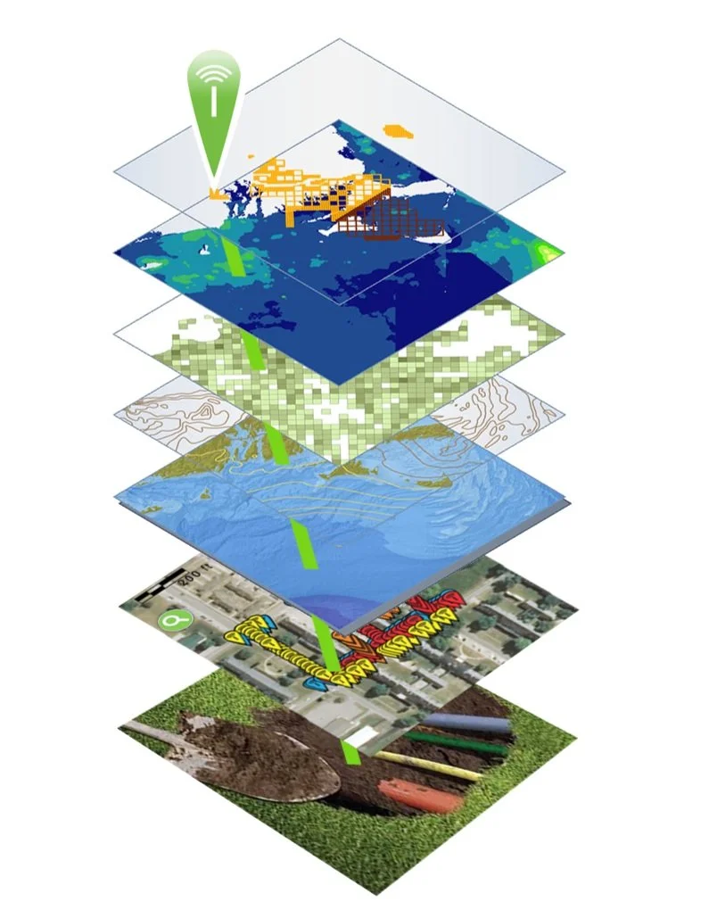
Layers in Geographic Information Systems, augmented with RFID
Augmented Reality (AR) and Virtual Reality (VR) Applications
Augmented Reality (AR) and Virtual Reality (VR) technologies are finding their way into land surveying practices, offering immersive experiences and enhanced visualization. AR and VR applications enable surveyors to overlay survey data onto the real world or create virtual environments for project planning and simulation. These technologies aid in communication, decision-making, and public engagement, providing stakeholders with a better understanding of the surveyed area and proposed designs[3]. These visualizations are extremely precise when surveying measurements include the use of high-quality prisms that help ensure accuracy – available from Berntsen.Geographic Information Systems (GIS)
Cloud-based Geographic Information Systems provide centralized storage, access, and analysis of map-based survey data. GIS is another technology that was first developed in the 1960s using existing spatial analysis and visualization methods, combined with computing power, to identify and manage land characteristics and use over large areas. Soon the usefulness of a spatially based approach to data visualization and analysis was applied to a vast range of functions. Today, GIS is becoming more and more powerful through the integration of other technologies, including Radio Frequency Identification (RFID) and AI.
Radio Frequency Identification (RFID)
As data visualization gets better and better, it becomes increasingly important to ensure that the data itself is precise. That’s where RFID comes in. RFID literally ties the physical to the digital, authenticating any marked asset at its physical location. An RFID tag, placed on anything anywhere can be instantly read on-site, activating its full data record from the GIS or BIM platform. Today, the combination of GIS and RFID is used to verify and manage a vast array of items – from infrastructure assets to dinosaur bones. Berntsen offers a full range of RFID tags and software that integrate with GIS, BIM and other platforms to provide instant authentication to any asset, anywhere.Artificial Intelligence (AI)
AI is set to bring another wave of change to the way we live. AI is the ability of a machine to display human-like capabilities such as reasoning, learning, planning and creativity. AI enables technical systems to perceive their environment, deal with what they perceive, solve problems and act to achieve a specific goal. The computer receives data - already prepared or gathered through its own sensors such as a camera - processes it and responds. AI systems can adapt their behavior to a certain degree by analyzing the effects of previous actions and working autonomously[4].
Combining AI with geographic information system (GIS) and RFID technology delivers real-world context and authentication to operations.

According to Esri, close observers of AI have noted that as an analytic tool, much of what it accomplishes falls into three main categories in which AI and location intelligence fit seamlessly:
Automate tasks and repeat them quickly at scale. A utility company can use AI and location intelligence, along with drone [and RFID] technology, to examine utility poles and wires, determining where telltale signs suggest repairs are necessary.
Look at past patterns to make predictions. A logistics or manufacturing company can use AI and location intelligence to optimize supply chains, considering such disparate data as weather forecasts, the likelihood of ship and rail traffic backup, and how many left-hand turns there are on driving routes.
Search for patterns hidden in large amounts of data[5].
A key point

In the midst of the Fourth Industrial Revolution, it’s important to remember that there are some things that data, computing and visualization can’t do. Every person exists in the physical world, not as a consumer or data point, but as living, breathing, thinking being.
At Berntsen, we put people first, by caring for our customers, anticipating future needs, and providing personal support, from live webinars to one-on-one meetings. We all want to leave our mark, and Berntsen is here to help.
References:
[3] https://www.pointscan.co.uk/the-evolution-of-3d-laser-scanning/
[5] https://www.esri.com/content/dam/esrisites/en-us/media/ebooks/artificial-intelligence.pdf
Background:
https://www.landform-surveys.co.uk/news/thoughts/ai-surveying/
https://www.linkedin.com/pulse/emerging-trends-land-surveying-practices-primaverse/

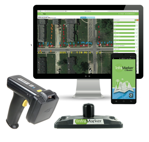
InfraMarker Brings RFID Power to Esri Field Operation Applications
Berntsen International, a leading manufacturer of infrastructure marking products, announces that its InfraMarker RFID app is now fully integrated with Esri’s ArcGIS Survey123 and ArcGIS Field Maps mobile applications.
MADISON, Wisc., July 3, 2023 - Berntsen International, a leading manufacturer of infrastructure marking products, announces that its InfraMarker RFID app is now fully integrated with Esri’s ArcGIS Survey123 and ArcGIS Field Maps mobile applications.
Berntsen’s InfraMarker app connects passive UHF RFID – the fastest growing asset identification technology in the world, with Esri’s ArcGIS, the global market leader in geographic information system (GIS) software. The InfraMarker app enhances Esri’s field data collection tools with the ability to read RFID tag information, write data to a RFID tag, associate the RFID serial number with the asset record in the GIS database, and launch inspection and management forms with a RFID interrogation.
“We are proud to bring RFID – the serial number of IoT – to Esri customers across the globe. We are confident that infrastructure managers in utilities, public works, and construction will realize speed, reliability, and cost benefits with InfraMarker RFID,” said Mike Klonsinski, president of Berntsen.
InfraMarker, a division of Berntsen International, is the leader in connected RFID-enabled infrastructure asset marking products and software. The InfraMarker line includes rugged RFID-enabled marking products, RFID readers and accessories, and RFID-connecting software to enhance GIS and asset management platforms.
About Berntsen International, Inc.
Since 1972, Berntsen International has provided high quality marking products to define the boundaries and infrastructure of the world. Berntsen marking products have been deployed throughout the world and its survey caps and monuments are recognized as the global standard.
Berntsen’s commitment to better infrastructure marking is taken to the next level with its innovative InfraMarker line of software, products, and solutions. The InfraMarker approach enables a connected infrastructure world by linking GIS platforms with RFID asset marking technology. Connected RFID infrastructure improves safety and field operations management for utilities, municipalities, and other organizations desiring better field asset management.
Berntsen is a Silver Partner in the Esri Partner Network, and InfraMarker RFID is an approved ArcGIS System Ready Specialty accessible on Esri's ArcGIS Marketplace. Visit Inframarker.com for more information and to purchase an introductory InfraMarker RFID package.

RFID - the technology that keeps on giving
We’ve all heard of RFID, a technology that’s been around since the 1930s. Did you know that it’s now one of the fastest-growing technologies in the world?
We’ve all heard of RFID, a technology that’s been around since the 1930s. Did you know that it’s now one of the fastest-growing technologies in the world?
Originally discovered during the development of radar, Radio Frequency Identification (RFID) has proven useful in all kinds of applications, from tracking library books to identifying lost pets to providing visibility into complex supply chains.
The technology is simple and versatile, consisting of a tiny RFID chip/antenna and a RFID reader that interrogates the chip via radio waves. No line of sight is required, and the tiny chips don’t require batteries – the power comes from the RFID reader.
Exponential RFID Market Growth

According to a presentation at the recent RFID Journal Live Conference (May 9-11, 2023), the RFID tag market is growing exponentially. This vibrant market growth will continue as RFID is integrated into more and more systems, including Geographic Information Systems, robotics and more.
The lasting impact of one person on the industry
Early on, in 2002, a reporter for Information Week realized the potential of the fledgling RFID market. About that time, manufacturing companies were trying to get a handle on how to prevent pervasive problems with inventory management and managing shipping information. RFID was one of the many technologies that was being tested to help resolve these problems. The reporter, Mark Roberti, focused his investigative skills on learning all he could about this fledgling technology. Little did he know that the result of his efforts would create a new career and an industry powerhouse.
Soon, Roberti created a website just to post his RFID articles, but it wasn’t until a reader asked about a subscription to the website that he realized he could make money by sharing his fascination with RFID. By 2003, Roberti was organizing annual conferences and online events. In 2007, his efforts received an unexpected boost by a corporate mandate by Walmart – that all suppliers must begin using RFID tags to mark their products. Of course, this mandate resulted in a rush of interest in RFID, as well as a lot of pushback from suppliers. More importantly, a patent holder for RFID technology began to enforce its patents. This stymied the corporate investment in RFID -- until Roberti stepped in and helped the industry manage licensing issues.
Before the advent of social media and e-commerce, the RFID industry found itself the focus of misinformation. In 2008, some consumer organizations began boycotting clothing with embedded RFID tags, erroneously believing that the tags would enable companies to spy on their customers. These groups got a lot of media attention, but the inherent versatility of RFID enabled manufacturers to resolve the issue (if not the misinformation). The RFID tags were simply placed on removable tags.
Growing with RFID

Back in 2010, Berntsen recognized the potential RFID could have on marking and managing underground infrastructure. Leveraging its broad expertise in infrastructure marking, the company began developing a system based on RFID technology that enabled users to digitally locate and manage their infrastructure assets. Unlike mapping or GIS platforms, an RFID-based system starts with the physical asset marked with an RFID tag. A simple scan of the tag verifies the asset’s identity and ties it to its specific digital record in a corresponding digital platform. RFID alone can provide this two-factor verification of any asset – a benefit especially relevant for buried infrastructure assets.
Today, Berntsen’s InfraMarker Connected RFID is leveraged by Esri to provide RFID verification to its customers that rely on ArcGIS to manage their assets. More and more organizations are benefitting from the versatility and security of InfraMarker RFID.

National 811 Day - little known but important!
It’s National 811 Day – a very important, but little-known commemoration. Anyone who is planning to disturb the ground should call this number before digging or excavating – or go to call811.com and connect online. Once you provide the area of excavation, locators will come out and mark the location of buried gas pipes, water lines, power cables and other underground utilities.

It’s National 811 Day – a very important, but little-known commemoration. Anyone who is planning to disturb the ground should call this number before digging or excavating – or go to call811.com and connect online. Once you provide the area of excavation, locators will come out and mark the location of buried gas pipes, water lines, power cables and other underground utilities.
This call can save your (or someone else’s) life. According to the Pipeline and Hazardous Materials Safety Administration (PHMSA), ruptured gas distribution systems have killed 12 people already this year. Since 2005, 225 people have died due to damages to gas distribution systems, with total damages to public and industry property of nearly $8.5 billion*. These are the statistics for the gas distribution industry alone.
For firms that are excavating every day, the need to “Know what’s below” is essential for safe operations.
The 2020 DIRT Report (Damage Information Reporting Tool) provides a more comprehensive picture of damages caused by all types of underground utility strikes – though the reporting is voluntary, not mandatory. The Common Ground Alliance (CGA) estimates that utility strikes result in $30 billion of direct and indirect costs every year. The most common root cause listed for these utility strikes was “failure to notify” (they didn’t call 811) before excavation.
The top five root causes of damage (70% of all reported damages):

No 811 call
No test hole dug for verification (pothole)
Facility marked inaccurately due to abandoned facility
Facility not marked due to excavator error
Excavator failed to maintain clearance for verifying marks
The truth is that no one knows how much damage results from excavation errors. In many sectors, there are no legal requirements for reporting utility strikes. Although a growing number of companies are voluntarily reporting, the data provides a very incomplete picture.
Until uniform processes and regulations are developed for marking and managing underground utilities, many utilities, construction companies and data centers are leveraging technology to “know what’s below”.
Geographic Information Systems (GIS) + Radio Frequency Identification (RFID)

GIS is a game-changing technology that is seeing explosive growth in many sectors, because it allows users to visualize data spatially. Passive RFID is the fastest growing identification technology and is also incredibly versatile – it provides a unique ID that can be tied to any type of data.
The convergence of these two technologies is fueling a new approach to managing utilities, called InfraMarker Connected RFID. GIS provides the maps, and InfraMarker RFID provides the location and asset verification essential to repair and maintenance crews in the field.
RFID delivers a direct connection between the buried asset and the geospatial map that is being used to locate the asset. Geospatial data is very good at visualizing an underground utility, but these visualizations don’t always provide the accuracy that is required in the real world, where a utility strike could result in a project delay (or disaster).
RFID provides field crews the two-factor verification that proves the identity and location of the scanned asset – even below ground. Esri’s Survey123 and Field Maps field data collection apps incorporate this highly accurate data into existing workflows. It is a game-changer for installation and maintenance crews, because now they can “know what’s below”.
How it works
It’s simple – an RFID tag is affixed on or near an asset (above or below ground). Each RFID tag has a unique ID that is linked to that asset’s record in GIS. Once linked, a field technician can scan a tag and automatically load that asset’s specific record for updating. No need for a line of sight with RFID, so this makes InfraMarker perfect for underground utilities.
The advantage of InfraMarker RFID is the accuracy it delivers to help utilities better manage their infrastructure assets. A value-add is that this data could also help prevent excavation strikes, helping everyone “Know what’s below”.
Until every buried utility is marked with InfraMarker RFID, it’s essential to call 811 before excavation – it can be a matter of life and death!
Give InfraMarker a try with our new Starter Kit!
Interested? Contact - info@inframarker.com

Marking and Mapping – Two Factor Verification for Underground Locating
It’s spring and construction is booming . . . hopefully with fewer actual “booms”, caused by utility strikes. Safe digging is something that’s near and dear to surveyors and any profession that involves excavation. As I mentioned in my last blog, preventable utility strikes cost at least $60 billion annually, not to mention the loss of life and life-altering injuries that can occur.
Blog by Emily Pierce, PLS, CFedS
It’s spring and construction is booming . . . hopefully with fewer actual “booms”, caused by utility strikes. Safe digging is something that’s near and dear to surveyors and any profession that involves excavation. As I mentioned in my last blog, preventable utility strikes cost at least $60 billion annually, not to mention the loss of life and life-altering injuries that can occur.
Geographic Information Systems (GIS)
GIS has emerged as a leading approach to managing utility assets and will become an essential tool for subsurface utility management. But regardless of how accurate GIS maps become, there will always be the need to validate the digital representation of the underground assets depicted in the maps with high quality in-field marking products. Mapping and marking is required.
In today’s world, this is called ‘two-factor’ verification and it is used in solutions like Uber (mobile map coupled with driver verification on arrival), online banking (text to phone to validate your account ownerships you) and your doctor’s office (“please tell me your name and date of birth”).
Surveyors have practiced this for years by using maps and then relying on Berntsen survey markers in the field. Two-factor verification drives safety, reduces errors in identification, and improves operational performance. There is no industry with greater need for two-factor verification than underground locating.
Technology to the Rescue
It is this two-factor verification that Berntsen has been working on with its InfraMarker RFID underground locating solutions. Tying an underground RFID asset identifier to a GIS delivers the best of both worlds – an accurate map with in-field verification.
I can’t help but think of the impact Connected RFID could have on preventing utility strikes if it was widely used. An RFID underground marker has a unique identifier tied to a GIS record so a field worker can identify the asset or particular location – not simply type of utility – before excavating. And RFID is utility agnostic, so the same locating and identification process works for water, gas, electric, or fiber.
We use two-factor verification to make sure we don’t get into the wrong Uber. Why can’t we take the same two-factor approach to make sure that we have safer underground digging?
Questions? Let us know!

Blossoming Blooms
Harmful algae blooms (HABs) are occurring more and more frequently in lakes, rivers, streams and coastal areas across the United States. Further, HABs are occurring where they were never found in the past. View a map from the Natural Resources Defense Council that tracks HABs across the United States.
CONTAINING THE THREAT OF HARMFUL ALGAL BLOOMS (HABS) IN URBAN ENVIRONMENTS
Harmful algae blooms (HABs) are occurring more and more frequently in lakes, rivers, streams and coastal areas across the United States. Further, HABs are occurring where they were never found in the past. View a map from the Natural Resources Defense Council that tracks HABs across the United States.
The chart below tracks the number of reports of algal blooms over time up to October 2021.
NUMBER OF HARMFUL ALGAL BLOOMS IN THE U.S. BY YEAR

WHAT IS A HARMFUL ALGAL BLOOM?
An algal bloom is an overgrowth of microscopic algae or algae-like bacteria in fresh, salt or brackish water. Many type of algae or bacteria can produce algal blooms; not all are toxic and not all are harmful. Less than one percent of algal blooms produce toxins; harmful algal blooms (HABs) are those that have negative impacts on humans, marine and freshwater environments and coastal areas.
The most common types of harmful freshwater algal blooms are caused by cyanobacteria. Some types of cyanobacteria can produce dangerous cyanotoxins. Some of these cyanotoxins can attack the liver, kidneys, central nervous systems, skin and lungs, resulting in serious damage or even death.
WHAT CAUSES HARMFUL ALGAL BLOOMS?
HABs can occur naturally, but the increasing prevalence and frequency is caused by:
Nutrient pollution, such as agricultural runoff, wastewater and stormwater runoff (which is increasing due to more frequent severe rainfall events).
Warmer temperatures.
Still water, such as in dams, canals and other man-made waterways.
STORMWATER MANAGEMENT – THE FIRST LINE OF DEFENSE AGAINST HABS
HABs have a significant, yet largely unmeasured economic impact. Looking at just the recreation and tourism industry, a single harmful algal bloom event in a lake in Ohio cost $37-$47 million in lost tourist revenue over two years.*

The reduction of nutrient pollution is the most accessible and effective method of reducing algal blooms in urban areas. It is estimated that 10 trillion gallons of untreated stormwater now flow into our lakes, rivers, streams and coastal areas.
Many municipalities are implementing asset management programs (AMPs) to help quantify and manage their stormwater infrastructure. Because infrastructure was built over a long period of time, it’s likely that documentation fragmented and inaccurate, which makes efficient maintenance very difficult. Actually knowing the location and condition of infrastructure assets goes a long way in creating a proactive plan to inspect, manage and repair existing assets.
SMALL INVESTMENTS IN PROVEN TECHNOLOGY CAN MAKE A BIG DIFFERENCE

Reading an RFID marker on a catch basin.
Fortunately, cost-effective technology is available to help make efficient asset management available to municipalities. Rather than keeping track of stormwater assets on paper and then digitizing the information, many municipalities have gone digital, using Geographic Information Systems (GIS) to keep track of their catch basins, swales, hydrants and other assets. However, in many cases, even if all the assets are viewable on a GIS system, truly useful data is not.
For example, a single intersection may have literally dozens of manholes, storm drains, catch basins, hydrants and other assets that require regular inspection and maintenance. GIS systems don’t have a way to identify discrete assets in close proximity. That’s where the InfraMarker system comes in. It offers a way to link verified physical location with the digital world using simple, proven technology.
Any asset that is marked with a RFID tag can be linked to unlimited asset information in a GIS using a simple mobile app. Field technicians can verify with certainty where they’re at and then link their maintenance activity with that specific asset – no guesswork or wasted time involved.
Asset managers benefit because they can view all assets online and delve into each specific record to view videos, photos and any other documentation the field tech has attached to the specific tag. An audit trail has been created so asset managers can schedule inspections and maintenance knowing that there will be no confusion or wasted time in the field dealing.
*Estimated Annual Ecomonic Impacts from Harmful Algal Booms (HABs) in the United States, WHOI-2000-11.

It’s GIS Day!
Most people don’t really think about how geographic information provides the framework for our entire existence. We exist as living organisms in time and space. Our minds may be occupied with far-way thoughts, but our memories are inextricably tied to the place where they were created. As long as we live and breathe, we always have a location.
Blog by Emily Pierce, PLS, CFedS

Most people don’t really think about how geographic information provides the framework for our entire existence. We exist as living organisms in time and space. Our minds may be occupied with far-way thoughts, but our memories are inextricably tied to the place where they were created. As long as we live and breathe, we always have a location. Shakespeare’s Hamlet said “To be or not to be, that is the question.” Surveyors say, “To be is to occupy a position relative to two axes.”
Surveyors are trained to understand the implications of geography and location differently than most people. Precision is applied to location and this information has been the basis for civilizations for thousands of years. I’ve written about ancient surveying instruments in previous blogs: Ancient Egyptian Surveying and Ancient Roman Surveying.
Today, geographic information is more important than ever and is being used in ways that were previously unimaginable. As a surveyor, I had the opportunity to work with Geographic Information Systems (GIS) early on, mainly by being the boots on the ground that provided accurate geographic data that was subsequently used in GIS. We provided accurate survey-grade locations on US Public Land Survey corners (section and quarter-section corners) to be utilized into a county tax parcel database. This not only helped improve how the county taxed its citizens, it also helped citizens with land development, taking into account appropriate building sites, flood zones, wetland preservation, general zoning requirements, just to name a few. Beyond that, the GIS also is used for school and voting districts, changes in municipal boundaries and incorporations, addressing, and emergency response management.
Nothing stays the dame
Change has accelerated quickly in the years since I started working with GIS, as evidenced by a 2009 article entitled the “Top Five Benefits of GIS”, with number one benefit being cost savings from greater efficiency using location-based data.
The example cited was Sears, which was able to use GIS to reduce the time it took for dispatchers to create routes for their home delivery trucks by 75%. I’m sure that was a huge savings, but unfortunately for Sears, Amazon was already taking over on every front. By 2021, the Sears footprint had shrunk from 3,862 stores in 2009 to just 19 stores and a website.
Route optimization is only one of the thousands of applications of GIS technology. From precision farming to spatial econometrics (the intersection of spatial analysis with economics) to creating ultra-precise road maps to facilitate autonomous vehicles. Check out the 1,000 Uses of GIS for a glimpse into the future.
When researching this blog, I learned about a project where Toyota is using a platform that gathers crowd-sourced data from vehicle cameras and combines it with high-precision GPS and GIS to create precise and up-to-date road information. This information will be used for autonomous driving in the future, or probably already is!
What?!
Interestingly, a whole new industry is being created around monetizing the vast amount of data that is generated from vehicles. McKinsey estimates the market for this information might add up to $450-650 billion by 2030. I wish there was some way I could get a cut of these billions!
You may not even realize that the navigation systems in your vehicles are GIS. I’m partial to the Waze app. I love how they incorporate real-time data on reported crashes, speed traps and even roadkill, (important to know, because we have lots of moose and deer up here)! All this can be narrated by people from Dexter on Showtime to PAW Patrol on Nickelodeon.
Other GIS uses

Pretty much everyone knows about the Johns-Hopkins COVID map but did you know that there’s a HealthMap that maps reports the location of all kinds of diseases? For example, in the past month, Legionnaires’ Disease was found in three locations in the U.S. Definitely worth looking at before traveling. NASA is also providing satellite data to cancer researchers to help pinpoint the types of human activity that lead to cancer in geographic areas. The Landsat Program is the longest continuous space-based record of Earth’s land in existence.
As you know, I’m a history buff, and I really like the ArcGIS Online Historical Maps. It makes all the USGS topographical maps accessible. All you need to do is find a place, and any maps that USGS has on it over time will be available. I just downloaded this map form 1890 of New Orleans.
I could go on and on, but I invite you to check out the many ways GIS is being used today.
I know in the past, many surveyors thought that GIS was going to obsolete the profession, but that is definitely not the case. We still need boots in the field tying the data in digital maps to real places in the real world. I’m personally involved in introducing a product that does just that, using RFID to literally tie the physical to the digital. Check it out at inframarker.com. It’s a great product with as many applications as GIS itself.
Emily Pierce is a surveyor and Berntsen’s Business Development Manager. Learn more - email: info@inframarker.com

INFRAMARKER BY BERNTSEN AWARDED THE ESRI RELEASE READY SPECIALTY DESIGNATION
Berntsen International, the leader in infrastructure marking solutions, announces that it has earned the Esri Release Ready Specialty status. This designation recognizes companies, products and solutions that integrate with Esri technology and are created by partners with expertise in leveraging Esri solutions and software.

MADISON, Wisc. March 24, 2021 - Berntsen International, the leader in infrastructure marking solutions, announces that it has earned the Esri Release Ready Specialty status. This designation recognizes companies, products and solutions that integrate with Esri technology and are created by partners with expertise in leveraging Esri solutions and software.
InfraMarker®, a division of Berntsen International, is the leader in connected RFID-enabled infrastructure asset management. The full InfraMarker line includes rugged RFID-enabled marking products, RFID readers and accessories designed for exceptional field performance, and RFID-connecting software enhancements that leverage Esri’s data collection capab. The InfraMarker approach delivers an essential connected solution for AEC firms, utilities, municipalities and other organizations that design and manage infrastructure assets.
The InfraMarker Web Widget for ArcGIS Web AppBuilder is the latest in InfraMarker’s connected RFID software line. Field personnel using the InfraMarker Web Widget with a web app simply scan an asset RFID tag to confirm the asset ID. The asset’s specific records or inspection forms will automatically launch from the organization’s platform. The process reduces time, cost, and errors while improving compliance controls.

“The InfraMarker Web Widget for ArcGIS Online is a perfect example of the innovation Esri helps make possible,” said Frank Martin, Esri Partner Manager. “This solution enables clients to streamline field asset management while creating accurate, auditable records in ArcGIS Online. InfraMarker provides a simple solution to data collection and compliance issues faced by a range of industries.”
Benefits of the InfraMarker enabled solution:
Simple, Unified Approach – InfraMarker simplifies the asset identification and data collection process in the field. The Web Widget is customizable using ArcGIS Web AppBuilder and easily integrates with ArcGIS Online. Field users can quickly access asset data, maps, files (including images and video) and transmit verified asset data in real-time from the field to the office, enabling up-to-date, accurate asset management.
Scalability and Flexibility – The InfraMarker RFID Solution can mark and manage any asset – above or below ground. RFID tags are incorporated into utility posts, affixed directly on infrastructure assets, or placed underground to identify pipelines, telecom, electric – any asset that needs to be located or tracked.
Improved ROI in the field – InfraMarker eliminates the guesswork involved in identifying specific assets and accessing the correct forms. A simple date/time stamped RFID scan activates an asset’s data record and presents the correct associated record or data collection form on the user’s mobile device. This streamlines operations while enhancing accuracy and providing an audit trail.
“We’re pleased to offer the InfraMarker RFID Web Widget to Esri’s ArcGIS clients,” said Mike Klonsinski, Berntsen International president. “The offering is another advancement in our commitment to enabling a smarter infrastructure world.”
About Berntsen International, Inc. and it’s InfraMarker solution
As an infrastructure marking company founded in 1972, Berntsen has been developing smart marking products for more than a decade. Its patented InfraMarker RFID solution combines the durability and precision of Berntsen marking products with a unique application of RFID technology specifically developed to connect physical markers with digital records. Berntsen has been an Esri Silver Partner for more than 10 years.
About ESRI
Esri, the global market leader in geographic information system (GIS) software, location intelligence, and mapping, helps customers unlock the full potential of data to improve operational and business results. Founded in 1969 in Redlands, California, USA, Esri software is deployed in more than 350,000 organizations globally and in over 200,000 institutions in the Americas, Asia and the Pacific, Europe, Africa, and the Middle East, including Fortune 500 companies, government agencies, nonprofits, and universities. Esri has regional offices, international distributors, and partners providing local support in over 100 countries on six continents. With its pioneering commitment to geospatial information technology, Esri engineers the most innovative solutions for digital transformation, the Internet of Things (IoT), and advanced analytics.
Visit us at esri.com.