
Key Trends in 2024
The “Fourth Industrial Revolution” is well underway. Back in 2011, economist Klaus Schwab coined the term to refer to the rapid digitization and accessibility of technologies that spark a global shift in processes – in everything from how we communicate to how businesses and governments are managed.

The “Fourth Industrial Revolution” is well underway. Back in 2011, economist Klaus Schwab coined the term to refer to the rapid digitization and accessibility of technologies that spark a global shift in processes – in everything from how we communicate to how businesses and governments are managed[1].


Drone image by Florian Pircher from Pixabay

Building information model of a mechanical room developed from lidar data (image provided by Yelda Turkan, OSU College of Engineering).
More a decade later, this revolution is accelerating, driven by the widespread use of cloud computing, “big data”, virtual reality and artificial intelligence (AI). These “disruptive technologies[2]” are fundamentally changing our lives and how we do our jobs. All industries, including surveying and civil engineering, are leveraging these new technologies to automate tasks, increase precision and generate more useful data.
Integration of 3D Laser Scanning Technology (LiDAR)
3D laser scanning traces back to the early 1960s when researchers experimented with laser technology to measure distances and create 3D representations of objects. The first practical applications of laser scanning emerged in the 1970s, in the field of surveying and topographic mapping. However, 3D laser scanning didn’t become useful until advancements in computing power and data processing capabilities were integrated with portable scanning technology. Today, surveyors can combine 3D scanners with their total stations to measure distances and create accurate three-dimensional representations of the surveyed area. The use of 3D laser scanning enhances data collection speed, accuracy, and enables more comprehensive visualization and analysis[3]. Berntsen offers a line of laser targets designed to work with these advanced systems – enhancing accuracy and ensuring repeatability.Drones
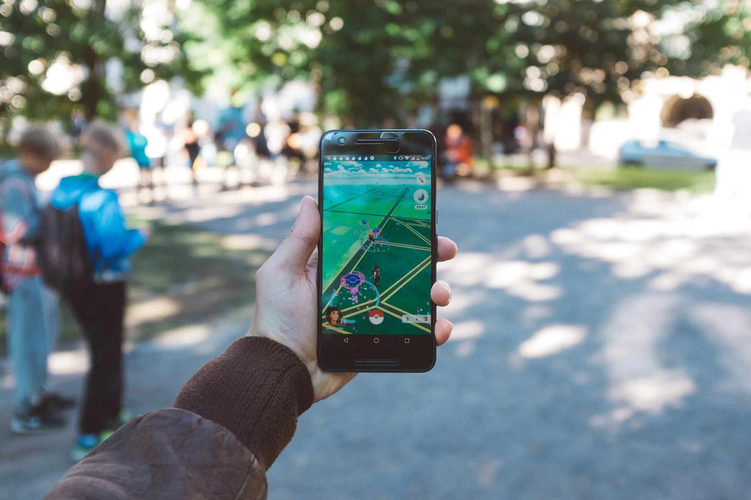
Drones equipped with high-resolution cameras and LiDAR sensors capture imagery and terrain data, allowing surveyors to obtain valuable insights for mapping, topographic surveys, and volumetric calculations. This technology makes it possible to survey inaccessible areas, reducing field time and increasing the efficiency of data collection and processing[3]. Of course, having accurate reference points is key to successful aerial surveying – see how Berntsen’s drone targets can work for you.Building Information Modeling (BIM)
BIM uses a range of technologies to create a digital representation of a structure or infrastructure project, integrating survey data with architectural, engineering, and construction information. Surveyors contribute crucial geospatial data to BIM models, facilitating clash detection, accurate quantity take-offs, and construction coordination. BIM enhances collaboration among project stakeholders, reduces errors, and enhances overall project efficiency[3]. Berntsen helps surveyors ensure BIM data precision with its line of smart targets and reflectors.
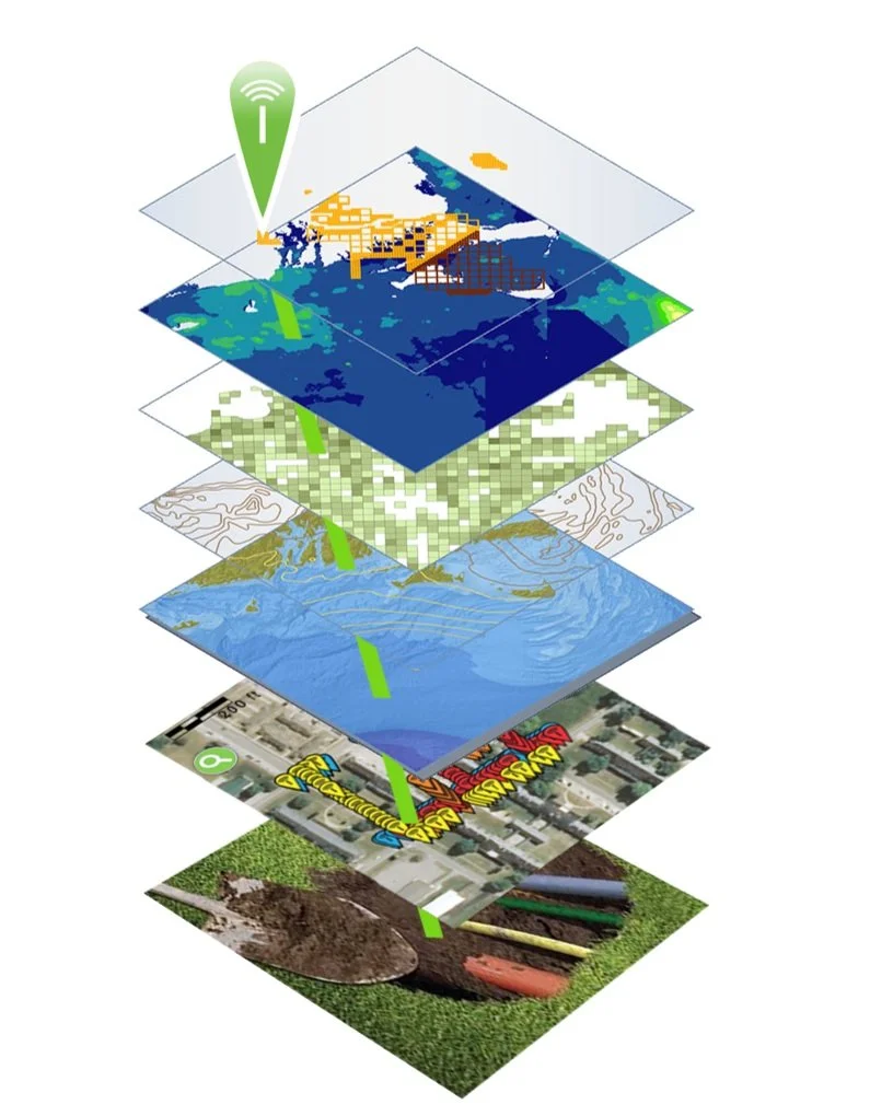
Layers in Geographic Information Systems, augmented with RFID
Augmented Reality (AR) and Virtual Reality (VR) Applications
Augmented Reality (AR) and Virtual Reality (VR) technologies are finding their way into land surveying practices, offering immersive experiences and enhanced visualization. AR and VR applications enable surveyors to overlay survey data onto the real world or create virtual environments for project planning and simulation. These technologies aid in communication, decision-making, and public engagement, providing stakeholders with a better understanding of the surveyed area and proposed designs[3]. These visualizations are extremely precise when surveying measurements include the use of high-quality prisms that help ensure accuracy – available from Berntsen.Geographic Information Systems (GIS)
Cloud-based Geographic Information Systems provide centralized storage, access, and analysis of map-based survey data. GIS is another technology that was first developed in the 1960s using existing spatial analysis and visualization methods, combined with computing power, to identify and manage land characteristics and use over large areas. Soon the usefulness of a spatially based approach to data visualization and analysis was applied to a vast range of functions. Today, GIS is becoming more and more powerful through the integration of other technologies, including Radio Frequency Identification (RFID) and AI.
Radio Frequency Identification (RFID)
As data visualization gets better and better, it becomes increasingly important to ensure that the data itself is precise. That’s where RFID comes in. RFID literally ties the physical to the digital, authenticating any marked asset at its physical location. An RFID tag, placed on anything anywhere can be instantly read on-site, activating its full data record from the GIS or BIM platform. Today, the combination of GIS and RFID is used to verify and manage a vast array of items – from infrastructure assets to dinosaur bones. Berntsen offers a full range of RFID tags and software that integrate with GIS, BIM and other platforms to provide instant authentication to any asset, anywhere.Artificial Intelligence (AI)
AI is set to bring another wave of change to the way we live. AI is the ability of a machine to display human-like capabilities such as reasoning, learning, planning and creativity. AI enables technical systems to perceive their environment, deal with what they perceive, solve problems and act to achieve a specific goal. The computer receives data - already prepared or gathered through its own sensors such as a camera - processes it and responds. AI systems can adapt their behavior to a certain degree by analyzing the effects of previous actions and working autonomously[4].
Combining AI with geographic information system (GIS) and RFID technology delivers real-world context and authentication to operations.

According to Esri, close observers of AI have noted that as an analytic tool, much of what it accomplishes falls into three main categories in which AI and location intelligence fit seamlessly:
Automate tasks and repeat them quickly at scale. A utility company can use AI and location intelligence, along with drone [and RFID] technology, to examine utility poles and wires, determining where telltale signs suggest repairs are necessary.
Look at past patterns to make predictions. A logistics or manufacturing company can use AI and location intelligence to optimize supply chains, considering such disparate data as weather forecasts, the likelihood of ship and rail traffic backup, and how many left-hand turns there are on driving routes.
Search for patterns hidden in large amounts of data[5].
A key point

In the midst of the Fourth Industrial Revolution, it’s important to remember that there are some things that data, computing and visualization can’t do. Every person exists in the physical world, not as a consumer or data point, but as living, breathing, thinking being.
At Berntsen, we put people first, by caring for our customers, anticipating future needs, and providing personal support, from live webinars to one-on-one meetings. We all want to leave our mark, and Berntsen is here to help.
References:
[3] https://www.pointscan.co.uk/the-evolution-of-3d-laser-scanning/
[5] https://www.esri.com/content/dam/esrisites/en-us/media/ebooks/artificial-intelligence.pdf
Background:
https://www.landform-surveys.co.uk/news/thoughts/ai-surveying/
https://www.linkedin.com/pulse/emerging-trends-land-surveying-practices-primaverse/

It’s Safe Digging Month - for good reason
As surveyors intimately understand, it’s very important to know what’s below. Your life could depend on it. National Safe Digging Month was created in 2008 by the Common Ground Alliance (CGA) to bring visibility to protecting workers, utilities and the public by working to prevent utility strikes during excavation. This group is comprised of companies and individuals in every facet of the underground utility industry, including Berntsen.

Blog by Emily Pierce, PLS, CFedS
As anyone involved in construction intimately understands, it’s very important to know what’s below. Your life could depend on it. National Safe Digging Month was created in 2008 by the Common Ground Alliance (CGA) to bring visibility to protecting workers, utilities and the public by working to prevent utility strikes during excavation. This group is comprised of companies and individuals in every facet of the underground utility industry, including Berntsen.
It’s interesting to note that although utility strikes are incredibly damaging and expensive (costing an estimated $30 billion annually in societal costs that include direct [facility repair] and indirect [property damage, medical expenses, business closures, etc.*]), there is no nationwide approach to marking, mapping and locating underground utilities. There’s also no requirement to report excavation damages to any centralized clearinghouse, except for the gas industry that reports major incidents to the Pipeline and Hazardous Materials Safety Administration (PHMSA). That’s why the CGA has developed a voluntary process for reporting strikes and damages.
The organization’s latest report presents the data of this voluntary reporting (and data from the PHMSA) in a very thorough way that looks at every aspect of utility strikes. They’ve found that “year over year, hundreds of thousands of damages occur, and most of them can be attributed to the same handful of persistent root causes.**” With the recent, massive investment in infrastructure, the overall trend of rising damages will likely continue.
The latest Damage Information Report Tool (DIRT) Report (from 2020 data reported in 2021) reveals some interesting information.

Figure 8 above shows the same information for 2020 only. Beginning in 2019 and continuing in 2020, the “big three” root cause groups – No Locate Request, Excavating Issues and Locating Issues – are approximately equal.
U.S. damages were down by about 12% in 2020 vs. 2019, likely due to the initial pandemic response that slowed the trend towards more construction projects. An analysis shows that even though the numbers of reported incidents were down, the same root causes persisted. Twenty-six root causes are tracked year-over-year and five of these account for 70% of the damage events. These five are:
Failure to notify the one call center/811 (the largest root cause of damages)
Excavator dug prior to verifying marks by test-hole (pothole)
Failure to maintain clearance
Abandoned facilities
Locator error
It’s pretty clear that lack of due diligence is behind many of the strikes. Construction projects often have pretty tight deadlines and perhaps field operators don’t feel they have time to call 811 (or maybe they don’t even know 811 is available). Even if a locator has been called, there’s no guarantee that the locator has accurately marked the underground facilities.
Technology to the rescue!

It doesn’t seem like this issue should be impossible to resolve – with today’s technology, solutions are available. Berntsen’s InfraMarker Connected RFID is a solution that could make a huge impact on reducing utility strikes, and it’s already being used in by pipeline companies and in data centers to mark underground utilities. It uses RFID and middleware to tie physical assets to data in Esri’s ArcGIS using Field Maps or Survey123.
As more and more utilities and municipalities adopt GIS, Connected RFID is available to verify location and precisely identify what facilities and conflicts exist underground before excavation. RFID can be read through soil, asphalt and concrete, so anything marked can be located and identified, simply by scanning the RFID marker and accessing the record through Esri’s data collection tools. Data can be shared between utilities, making this essential information available to all.
As more and more infrastructure projects get underway, it’s more important than ever to prevent damaging utility strikes. Connected RFID is leading the way in future-enabling connectivity of any underground (or above ground) asset.
Questions? Contact us.

It’s GIS Day!
Most people don’t really think about how geographic information provides the framework for our entire existence. We exist as living organisms in time and space. Our minds may be occupied with far-way thoughts, but our memories are inextricably tied to the place where they were created. As long as we live and breathe, we always have a location.
Blog by Emily Pierce, PLS, CFedS

Most people don’t really think about how geographic information provides the framework for our entire existence. We exist as living organisms in time and space. Our minds may be occupied with far-way thoughts, but our memories are inextricably tied to the place where they were created. As long as we live and breathe, we always have a location. Shakespeare’s Hamlet said “To be or not to be, that is the question.” Surveyors say, “To be is to occupy a position relative to two axes.”
Surveyors are trained to understand the implications of geography and location differently than most people. Precision is applied to location and this information has been the basis for civilizations for thousands of years. I’ve written about ancient surveying instruments in previous blogs: Ancient Egyptian Surveying and Ancient Roman Surveying.
Today, geographic information is more important than ever and is being used in ways that were previously unimaginable. As a surveyor, I had the opportunity to work with Geographic Information Systems (GIS) early on, mainly by being the boots on the ground that provided accurate geographic data that was subsequently used in GIS. We provided accurate survey-grade locations on US Public Land Survey corners (section and quarter-section corners) to be utilized into a county tax parcel database. This not only helped improve how the county taxed its citizens, it also helped citizens with land development, taking into account appropriate building sites, flood zones, wetland preservation, general zoning requirements, just to name a few. Beyond that, the GIS also is used for school and voting districts, changes in municipal boundaries and incorporations, addressing, and emergency response management.
Nothing stays the dame
Change has accelerated quickly in the years since I started working with GIS, as evidenced by a 2009 article entitled the “Top Five Benefits of GIS”, with number one benefit being cost savings from greater efficiency using location-based data.
The example cited was Sears, which was able to use GIS to reduce the time it took for dispatchers to create routes for their home delivery trucks by 75%. I’m sure that was a huge savings, but unfortunately for Sears, Amazon was already taking over on every front. By 2021, the Sears footprint had shrunk from 3,862 stores in 2009 to just 19 stores and a website.
Route optimization is only one of the thousands of applications of GIS technology. From precision farming to spatial econometrics (the intersection of spatial analysis with economics) to creating ultra-precise road maps to facilitate autonomous vehicles. Check out the 1,000 Uses of GIS for a glimpse into the future.
When researching this blog, I learned about a project where Toyota is using a platform that gathers crowd-sourced data from vehicle cameras and combines it with high-precision GPS and GIS to create precise and up-to-date road information. This information will be used for autonomous driving in the future, or probably already is!
What?!
Interestingly, a whole new industry is being created around monetizing the vast amount of data that is generated from vehicles. McKinsey estimates the market for this information might add up to $450-650 billion by 2030. I wish there was some way I could get a cut of these billions!
You may not even realize that the navigation systems in your vehicles are GIS. I’m partial to the Waze app. I love how they incorporate real-time data on reported crashes, speed traps and even roadkill, (important to know, because we have lots of moose and deer up here)! All this can be narrated by people from Dexter on Showtime to PAW Patrol on Nickelodeon.
Other GIS uses

Pretty much everyone knows about the Johns-Hopkins COVID map but did you know that there’s a HealthMap that maps reports the location of all kinds of diseases? For example, in the past month, Legionnaires’ Disease was found in three locations in the U.S. Definitely worth looking at before traveling. NASA is also providing satellite data to cancer researchers to help pinpoint the types of human activity that lead to cancer in geographic areas. The Landsat Program is the longest continuous space-based record of Earth’s land in existence.
As you know, I’m a history buff, and I really like the ArcGIS Online Historical Maps. It makes all the USGS topographical maps accessible. All you need to do is find a place, and any maps that USGS has on it over time will be available. I just downloaded this map form 1890 of New Orleans.
I could go on and on, but I invite you to check out the many ways GIS is being used today.
I know in the past, many surveyors thought that GIS was going to obsolete the profession, but that is definitely not the case. We still need boots in the field tying the data in digital maps to real places in the real world. I’m personally involved in introducing a product that does just that, using RFID to literally tie the physical to the digital. Check it out at inframarker.com. It’s a great product with as many applications as GIS itself.
Emily Pierce is a surveyor and Berntsen’s Business Development Manager. Learn more - email: info@inframarker.com

SURVEYORS EMBRACE NEW TECHNOLOGY
According to an article in Point of Beginning citing a recent study, the surveying profession is undergoing some important changes.
The past five years have seen a notable drop in boundary surveys as the primary surveying activity -- from 35 percent in 2015 to just 15 percent in 2020.

Main Objective
Correspondingly, 27 percent of surveyors cite building / construction / engineering design as their firm’s primary business.
According to an article in Point of Beginning citing a recent study, the surveying profession is undergoing some important changes.
The past five years have seen a notable drop in boundary surveys as the primary surveying activity -- from 35 percent in 2015 to just 15 percent in 2020. Correspondingly, 27 percent of surveyors cite building / construction / engineering design as their firm’s primary business - up from just nine percent in 2015. Clearly, more and more surveying firms rely on the construction industry as their primary activity.
Additionally, with the needed investment in upgrading existing infrastructure nationwide, we will likely see this increase even more in the future.
A wave of new technology
As construction continues to become a bigger part of the business, surveyors are not only using new technology, they are becoming acquainted with new technologies used by their customers. For example, many construction and engineering firms contract with municipalities that use Geographic Information Systems (GIS) to map and track infrastructure assets. Asset location is represented on a digital map, which is very useful for centralized planning and administration of resources.
Unfortunately, the benefits of these digital asset mapping applications often do not seamlessly transfer to the field. Ideally, the digital map would guide field workers to the exact asset that has been assigned for inspection and maintenance. In practice, field workers discover that the physical assets don’t correspond to the digital location, or there are several assets in close proximity, making precise identification impossible. If the assets are buried, then each time an asset needs to be accessed, a time-consuming and costly locating process must be completed.
InfraMarker RFID tag marking an underground pipeline
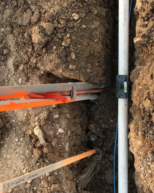
InfraMarker RFID tag marking an underground pipeline
This is where the work of surveyors can be of great benefit to organizations that use GIS-based asset mapping software. Asset management software is not based on survey-grade precision, which leads to ongoing locating problems in the future. Surveyors have the ability to generate the precise physical location data that is inherently of tremendous benefit to municipal or utility asset management programs.
A crucial reason why precise location information is so valuable to utilities is the prevalence of excavation utility strikes. The Common Ground Alliance found that in 2018, the single most frequent reason for underground utilities being mistakenly hit during excavation was “Notification NOT made” – meaning that locators were not used before excavation began.
However, if locators are used, it doesn’t mean that they provide exact information – the same report states that 24 percent of accidental utility strikes were due to Locating Issues.
That data illustrates the fact that existing utility locating methods are not sufficient. However, surveyors have the data and can offer a way to link specific, verified physical location to digital asset management data.
Surveyors can provide value-add to customers
The key is RFID. By combining RFID markers and simple smart phone applications, surveyors can provide an adaptable way to tie physical location with a customer’s GIS system. This offers a tremendous benefit to utilities because RFID can be tied into their digital asset system and provide verifiable asset location and data.
The InfraMarker system provides a turnkey way to quickly mark infrastructure assets.

InfraMarker RFID-tagged utility assets displayed on a cell phone screen.
InfraMarker RFID-tagged utility assets displayed on a cell phone screen.
For example, when surveyors mark the path for a new municipal water pipeline, RFID markers can be placed at key points, above or below ground. Each InfraMarker tag has a unique ID that can be immediately pulled into the GIS/Asset Management system, or it can be added to the GIS / asset management system later. InfraMarker tags last for decades, are passive (only activated when pinged by and RFID reader) and don’t require batteries so there’s no maintenance.
With InfraMarker, surveyors can offer lasting benefit to municipal and utility customers by anticipating their need to accurately digitize physical location.

SURVEYING THE FUTURE WITH RFID
Pretend we are visiting the site of an ALTA/ACSM survey 50 years from now. This is a site where we previously set the monuments using Berntsen RFID-enabled DEEP1 magnets. . .
Paul Mabry, editor of California Surveyor, offers a scenario of how RFID could be used in the the future. Berntsen’s Mike Klonsinski share how RFID makes that future possible - today.

Pretend we are visiting the site of an ALTA/ACSM survey 50 years from now. This is a site where we previously set the monuments using Berntsen RFID-enabled DEEP1 magnets. . .
Next, we deploy our drone outfitted with GNSS, a magnetic locator and RFID transceiver to hover over each monument coordinates to confirm the existing monuments and search for any missing monuments. . .