
It’s National 811 Day —
811 Day was created to bring attention to a significant but little-known issue – the high cost and safety impacts of underground utility strikes.
Quantifying the cost and safety impacts of utility strikes is difficult. A compilation of various studies estimates that the direct cost of each strike is $4,000 -- but that doesn’t take into consideration the cost to repair and restore the damage.

Little-known but incredibly important
811 Day was created to bring attention to a significant but unfamiliar issue – the high cost and safety impacts of underground utility strikes.
Quantifying the cost and safety impacts of utility strikes is difficult. A compilation of various studies estimates that the direct cost of each strike is $4,000 -- but that doesn’t take into consideration the cost to repair and restore the damage. Taken together, the cost of the strike plus the cost of restoration, the total is 29 times the cost of the direct damage itself [1]. Because utility strikes are often not reported, the frequency of occurrence is merely an estimate. With more than 20 million miles of buried pipelines, cables, wires and other facilities, the Common Ground Alliance (CGA) estimates that there are at least 400,000 utility strikes per year in the United States. In 2021, the cost of utility strikes to the US economy was estimated to be more than $30 billion.
Utility strikes have been a problem for a long time – ever since the 1850s when the first underground sewer systems were built in Chicago and Brooklyn.
Act of Congress
It wasn’t until 1994 that the government got involved. At that time, Congress required each state to develop a One-Call system with a centralized number to call in advance of digging. The goal of the one-call system is simplicity. Any person or company planning to excavate can call an in-state number and the utility companies would be notified to send a Utility Locator to find and mark utilities using spray paint and/or flags. Unfortunately, the number of One-Call Centers quickly grew to 71, each with its own 10-digit phone number, making it confusing and taxing to notify the right people before breaking ground.
In response, in 1995, the FCC designated 811 as the nationwide number to call (or click) to protect pipelines and other utilities from excavation damage.
Today, 811 is contacted nearly 40 million times annually [2].
Despite the fact that use of 811 one-call centers rose by eight percent from 2020 to 2021, “No notification made to 811 center” remains the top root cause of utility strikes with over a quarter of all damages still attributed to no notification)[3].
Much more to be done
Although it’s simpler than ever to call for utility location, utility strikes remain a major drag on the American economy. Fortunately, emerging technology is being used to produce precise maps of underground utilities that speed the process of identifying and locating underground utilities.
For example, Geographic Information Systems (GIS), are being used by growing numbers of utilities, municipalities and excavators to create and share data about underground utilities. Unfortunately, having an accurate map of all utilities in a given area is rare, because not every contractor or owner working on a job site uses GIS to map utilities. That’s when another technology, Radio Frequency Identification (RFID), can make all the difference. Magnetic RFID tags can be buried with any type of utility and will display its identity, owner and other information with a simple scan. This data can be incorporated into GIS (such as Esri’s ArcGIS) through data collection apps on mobile devices. RFID is agnostic, so it will work with any utility, above or below ground.
RFID and GIS are key
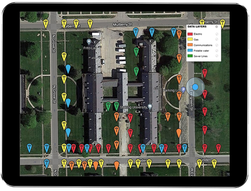
Passive RFID tags don’t require power (they activate only when scanned) so they can last underground for years. A recently released study describes how RFID has been used to mark and manage utilities over a period of seven years. The study concluded that magnetic RFID marking, coupled with GIS mapping, is a low-cost, reliable solution for underground infrastructure locating and management.
Marking underground utilities with magnetic RFID is a long-term solution that streamlines future utility locating processes while providing the means to connect to digital mapping systems for efficient utility management -- from water pipes to fiber-optic cables. Utility location verified by RFID, provides a highly accurate method for utility owners to manage all of their infrastructure facilities.
Today, on 8/11 calling 811 remains essential part any excavation, from individuals working in their backyards to construction companies about to break ground on a new project.
References:
[3] https://dirt.commongroundalliance.com/2021-DIRT-Report/Executive-Summary#mainContentAnchor
Sources:
https://www.4manalytics.com/blog/29-1-the-cost-of-striking
The 811 Logo is a registered trademark of the Common Ground Alliance

It’s Safe Digging Month - for good reason
As surveyors intimately understand, it’s very important to know what’s below. Your life could depend on it. National Safe Digging Month was created in 2008 by the Common Ground Alliance (CGA) to bring visibility to protecting workers, utilities and the public by working to prevent utility strikes during excavation. This group is comprised of companies and individuals in every facet of the underground utility industry, including Berntsen.

Blog by Emily Pierce, PLS, CFedS
As anyone involved in construction intimately understands, it’s very important to know what’s below. Your life could depend on it. National Safe Digging Month was created in 2008 by the Common Ground Alliance (CGA) to bring visibility to protecting workers, utilities and the public by working to prevent utility strikes during excavation. This group is comprised of companies and individuals in every facet of the underground utility industry, including Berntsen.
It’s interesting to note that although utility strikes are incredibly damaging and expensive (costing an estimated $30 billion annually in societal costs that include direct [facility repair] and indirect [property damage, medical expenses, business closures, etc.*]), there is no nationwide approach to marking, mapping and locating underground utilities. There’s also no requirement to report excavation damages to any centralized clearinghouse, except for the gas industry that reports major incidents to the Pipeline and Hazardous Materials Safety Administration (PHMSA). That’s why the CGA has developed a voluntary process for reporting strikes and damages.
The organization’s latest report presents the data of this voluntary reporting (and data from the PHMSA) in a very thorough way that looks at every aspect of utility strikes. They’ve found that “year over year, hundreds of thousands of damages occur, and most of them can be attributed to the same handful of persistent root causes.**” With the recent, massive investment in infrastructure, the overall trend of rising damages will likely continue.
The latest Damage Information Report Tool (DIRT) Report (from 2020 data reported in 2021) reveals some interesting information.

Figure 8 above shows the same information for 2020 only. Beginning in 2019 and continuing in 2020, the “big three” root cause groups – No Locate Request, Excavating Issues and Locating Issues – are approximately equal.
U.S. damages were down by about 12% in 2020 vs. 2019, likely due to the initial pandemic response that slowed the trend towards more construction projects. An analysis shows that even though the numbers of reported incidents were down, the same root causes persisted. Twenty-six root causes are tracked year-over-year and five of these account for 70% of the damage events. These five are:
Failure to notify the one call center/811 (the largest root cause of damages)
Excavator dug prior to verifying marks by test-hole (pothole)
Failure to maintain clearance
Abandoned facilities
Locator error
It’s pretty clear that lack of due diligence is behind many of the strikes. Construction projects often have pretty tight deadlines and perhaps field operators don’t feel they have time to call 811 (or maybe they don’t even know 811 is available). Even if a locator has been called, there’s no guarantee that the locator has accurately marked the underground facilities.
Technology to the rescue!

It doesn’t seem like this issue should be impossible to resolve – with today’s technology, solutions are available. Berntsen’s InfraMarker Connected RFID is a solution that could make a huge impact on reducing utility strikes, and it’s already being used in by pipeline companies and in data centers to mark underground utilities. It uses RFID and middleware to tie physical assets to data in Esri’s ArcGIS using Field Maps or Survey123.
As more and more utilities and municipalities adopt GIS, Connected RFID is available to verify location and precisely identify what facilities and conflicts exist underground before excavation. RFID can be read through soil, asphalt and concrete, so anything marked can be located and identified, simply by scanning the RFID marker and accessing the record through Esri’s data collection tools. Data can be shared between utilities, making this essential information available to all.
As more and more infrastructure projects get underway, it’s more important than ever to prevent damaging utility strikes. Connected RFID is leading the way in future-enabling connectivity of any underground (or above ground) asset.
Questions? Contact us.