
Public Works — Key to civilization
Public works have been around ever since people found ways to ensure a reliable source of water for their crops. In 4000 BC, the ancient Sumerians created a successful irrigation system that watered fields between the Tigris and Euphrates Rivers.
What does the term “Public Works” mean? It’s one of those terms that are so broad that it almost defies definition.
The American Public Works Association (APWA) says “Because of the multi-faceted, ever-evolving nature of public works, we may never arrive at a final definition but, for now, the following definition seems appropriate: Public works is the combination of physical assets, management practices, policies, and personnel necessary for government to provide and sustain structures and services essential to the welfare and acceptable quality of life for its citizens.”

Haghe, L. & Roberts, D. (1849) Excavated mansions of Petra, Petra, March 7. Extinct City Petra, 1849. [Published] [Photograph] Retrieved from the Library of Congress.
A Long History

By Saqib Qayyum - Own work, CC BY-SA 3.0,
A 2.4m deep, 12m long, and 7m wide pool known as "The Great Bath" is located at the centre of the Citadel, is made of fine baked waterproof mud bricks and a thick layer of bitumen. It is the earliest public water tank of the ancient world. Adjacent to it are a well that was used to supply water to the bath.
Public works have been around ever since people found ways to ensure a reliable source of water for their crops. In 4000 BC, the ancient Sumerians created a successful irrigation system that watered fields between the Tigris and Euphrates Rivers. In Mohenjo‐Daro, a major urban center of the Indus Civilization (India), a sophisticated system for supplying water and expelling sewage dates back to the mid-third millennium BC. Water came from more than 700 wells and supplied not only domestic demands but also a system of private baths and a Great Bath for public use. Drains and sewers were carefully constructed to facilitate the removal of waste.[1]
Beginning in 586 BC, the Nabataeans, who lived in northern Arabia and the southern Levant, created a sophisticated water collection system which allowed them to build an impressive trade empire in the heart of arid Arabia.[2]
Of course, everyone knows about the Romans, who constructed roads, harbor works, aqueducts, temples, forums, town halls, arenas, baths, and sewers – many of which are still seen today, more than 2,000 years later. These public works were designed to stabilize and strengthen the empire and make the lives of Roman citizens better.
Recent history

Segovia--El Puente. Segovia Spain, None. [Between 1900 and 1910] [Photograph] Retrieved from the Library of Congress.
Fast forward a couple thousand years, and public works became key to stabilizing the American economy during a time of crisis. Back in 1933, the federal government undertook a massive public works effort to counteract the devastating effects of the Great Depression. For a decade, the federal government poured $3.8 billion through the Public Works Administration (PWA) into projects that radically transformed the country’s infrastructure. Prominent projects included New York’s Triborough Bridge, Grand Coulee Dam, the San Francisco Mint, Reagan National Airport and Key West’s Overseas Highway.[3]
Later, in 1935, President Roosevelt used an executive order to create the Works Progress Administration (WPA). At the time, unemployment was holding steady at 20 percent, and the economy needed a serious boost. The WPA employed mostly unskilled men to carry out public works infrastructure projects. They built more than 4,000 new school buildings, erected 130 new hospitals, laid roughly 9,000 miles of storm drains and sewer lines, built 29,000 new bridges, constructed 150 new airfields, paved or repaired 280,000 miles of roads and planted 24 million trees to alleviate loss of topsoil during the Dust Bowl. Over the course of 10 years, the WPA put 8.5 million people to work, strengthening communities and laying the groundwork for the largest industrial expansion in history -- the wartime economy of 1945.
The Infrastructure Investment and Jobs Act

Grand Coulee dam construction. , None. [Between 1936 and 1946] [Photograph] Retrieved from the Library of Congress.
Today, the country is in the midst of another massive public works investment. The Infrastructure Investment and Jobs Act (IIJA) was signed into law on November 15, 2021. The IIJA is an historic investment in our nation’s infrastructure: $1.2 trillion over five years, including $550 billion in new federal spending, including --
passenger and freight rail;
highway and pedestrian safety;
public transit;
broadband;
ports and waterways;
airports;
water infrastructure;
power and grid reliability and resiliency;
resiliency, including funding for coastal resiliency, ecosystem restoration, and weatherization;
clean school buses and ferries;
electric vehicle charging;
addressing legacy pollution by cleaning up Brownfield and Superfund sites and reclaiming abandoned mines; and
Western Water Infrastructure[4]
The American Public Works Association (APWA)

The APWA is an organization that was founded to help public works professionals improve their skills, share information and work together to find the best ways to help their communities. Along with comprehensive training programs and other resources, the APWA helps its members learn about and apply for funds provided by the Infrastructure Investment and Jobs Act.
Each year, the APWA organizes a conference and exposition to help keep its members informed. This year’s conference, held in San Diego, includes 125 technical and professional development sessions using the latest learning models: classroom, interactive, and "live" learning labs. Additionally, more than 400 companies will be exhibiting the latest technology – including Berntsen International’s InfraMarker Connected RFID in booth 1939.
InfraMarker is key to smooth operations
Today, public works is more complex than ever. Even in small cities, more and more organizations are relying on the power of GIS to help manage their assets and streamline operations. InfraMarker RFID is designed to leverage the power of GIS to accurately mark and manage any type of asset - directly from the asset point itself. Each passive RFID marker identifies the asset, connecting to GIS with a simple scan, providing verified asset identity and launching the the associated workflow. This instant asset confirmation of ]identity removes guess-work from field maintenance and speeds routine inspection and maintenance with accurate documentation.
We invite all public works professionals who manage infrastructure assets to see how InfraMarker RFID can improve asset management by providing verified field asset information that links to any GIS system. Sign up here to chat with Brent Sherman, our Sales Manager for a live demo of how InfraMarker can work for you at the APWA Conference, booth 1939, August 27-29.
See how it works:

References:
[2] https://www.ancient-origins.net/artifacts-ancient-technology/nabateans-002193
[3] https://livingnewdeal.org/glossary/public-works-administration-pwa-1933-1943/
Sources:
https://livingnewdeal.org/glossary/public-works-administration-pwa-1933-1943/
http://www.waterencyclopedia.com/Tw-Z/Water-works-Ancient.html#ixzz89u0Sv4uO

It’s National 811 Day —
811 Day was created to bring attention to a significant but little-known issue – the high cost and safety impacts of underground utility strikes.
Quantifying the cost and safety impacts of utility strikes is difficult. A compilation of various studies estimates that the direct cost of each strike is $4,000 -- but that doesn’t take into consideration the cost to repair and restore the damage.

Little-known but incredibly important
811 Day was created to bring attention to a significant but unfamiliar issue – the high cost and safety impacts of underground utility strikes.
Quantifying the cost and safety impacts of utility strikes is difficult. A compilation of various studies estimates that the direct cost of each strike is $4,000 -- but that doesn’t take into consideration the cost to repair and restore the damage. Taken together, the cost of the strike plus the cost of restoration, the total is 29 times the cost of the direct damage itself [1]. Because utility strikes are often not reported, the frequency of occurrence is merely an estimate. With more than 20 million miles of buried pipelines, cables, wires and other facilities, the Common Ground Alliance (CGA) estimates that there are at least 400,000 utility strikes per year in the United States. In 2021, the cost of utility strikes to the US economy was estimated to be more than $30 billion.
Utility strikes have been a problem for a long time – ever since the 1850s when the first underground sewer systems were built in Chicago and Brooklyn.
Act of Congress
It wasn’t until 1994 that the government got involved. At that time, Congress required each state to develop a One-Call system with a centralized number to call in advance of digging. The goal of the one-call system is simplicity. Any person or company planning to excavate can call an in-state number and the utility companies would be notified to send a Utility Locator to find and mark utilities using spray paint and/or flags. Unfortunately, the number of One-Call Centers quickly grew to 71, each with its own 10-digit phone number, making it confusing and taxing to notify the right people before breaking ground.
In response, in 1995, the FCC designated 811 as the nationwide number to call (or click) to protect pipelines and other utilities from excavation damage.
Today, 811 is contacted nearly 40 million times annually [2].
Despite the fact that use of 811 one-call centers rose by eight percent from 2020 to 2021, “No notification made to 811 center” remains the top root cause of utility strikes with over a quarter of all damages still attributed to no notification)[3].
Much more to be done
Although it’s simpler than ever to call for utility location, utility strikes remain a major drag on the American economy. Fortunately, emerging technology is being used to produce precise maps of underground utilities that speed the process of identifying and locating underground utilities.
For example, Geographic Information Systems (GIS), are being used by growing numbers of utilities, municipalities and excavators to create and share data about underground utilities. Unfortunately, having an accurate map of all utilities in a given area is rare, because not every contractor or owner working on a job site uses GIS to map utilities. That’s when another technology, Radio Frequency Identification (RFID), can make all the difference. Magnetic RFID tags can be buried with any type of utility and will display its identity, owner and other information with a simple scan. This data can be incorporated into GIS (such as Esri’s ArcGIS) through data collection apps on mobile devices. RFID is agnostic, so it will work with any utility, above or below ground.
RFID and GIS are key
Passive RFID tags don’t require power (they activate only when scanned) so they can last underground for years. A recently released study describes how RFID has been used to mark and manage utilities over a period of seven years. The study concluded that magnetic RFID marking, coupled with GIS mapping, is a low-cost, reliable solution for underground infrastructure locating and management.
Marking underground utilities with magnetic RFID is a long-term solution that streamlines future utility locating processes while providing the means to connect to digital mapping systems for efficient utility management -- from water pipes to fiber-optic cables. Utility location verified by RFID, provides a highly accurate method for utility owners to manage all of their infrastructure facilities.
Today, on 8/11 calling 811 remains essential part any excavation, from individuals working in their backyards to construction companies about to break ground on a new project.
References:
[3] https://dirt.commongroundalliance.com/2021-DIRT-Report/Executive-Summary#mainContentAnchor
Sources:
https://www.4manalytics.com/blog/29-1-the-cost-of-striking
The 811 Logo is a registered trademark of the Common Ground Alliance

GIS + RFID = SUE Enhancement
Subsurface Utility Engineering (SUE) that leverages Geographic Information Systems (GIS) and Radio Frequency Identification (RFID) deliver substantial benefits in the management and protection of underground assets.
Subsurface Utility Engineering (SUE) that leverages Geographic Information Systems (GIS) and Radio Frequency Identification (RFID) deliver substantial benefits in the management and protection of underground assets.
Both GIS and RFID are rapidly-growing, powerful technologies that are used across a wide spectrum of industries, from manufacturing to agriculture to SUE.

When used together, GIS and RFID deliver accurate, verified information about any type of asset – above or below ground. This is particularly compelling for re-locating buried assets before excavation. It’s essential to know what’s below, and scanning the RFID buried asset tag provides authentication of its data in GIS.
RFID is a simple and durable technology, ideal for pairing with GIS. RFID tags consist of a microchip and antenna. Basic information, such as the asset’s location, identity and owner are written to the tag. When scanned, this data connects to GIS, accessing the correct data and launching maintenance/inspection surveys.
Today, a growing number of agencies and municipalities use Esri’s ArcGIS for Subsurface Utility Engineering. Esri’s popular data collection apps integrate with InfraMarker RFID, making accessible to any organization that uses ArcGIS and Field Maps or Survey123. Recently, Esri announced a June Survey123 update that includes a more seamless integration with InfraMarker RFID.
According to Esri:
“With InfraMarker, a field user can scan a RFID tag and instantly launch the related inspection form in Survey123 … faster and without errors in asset misidentification. You can also use InfraMarker for Survey123 to write information to a new RFID tag and easily associate the unique identifier in your ArcGIS system of record.
The technology is increasingly used in infrastructure asset management thanks to its durability in the field, flexibility to serve as a unique ID on almost any asset, and ability to be read from distance or through mediums such as walls, ground, or concrete.”
SUE and RFID for Infrastructure
This technology is on target for use in all kinds of infrastructure projects that rely on Subsurface Utility Engineering.
The 2022 CGA Technology Report notes that applying emerging mapping/GIS technologies in project design and SUE would reduce potholing and associated expenses involved in locating buried utilities.[1] This report delivers a snapshot of how technology is used specifically to prevent damage during excavation. RFID is included for facility installation and locating, and stated that “a comprehensive national GIS map of buried infrastructure would make the locating process drastically more efficient and accurate, and identify abandoned facilities.”
A recent longitudinal study has demonstrated the long-term feasibility of combining RFID and GIS.
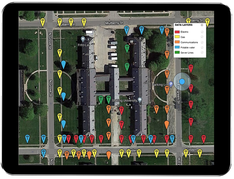
Staking University in Manteno, IL was the site for a perfect test case of using this technology in a residential setting. This campus encompasses more than 20 acres of live and abandoned utilities offering real-world conditions for field testing utility products.
Because RFID markers are passive, they can simply be scanned and connected to GIS for verification – even years later.
In 2015, 174 RFID markers were placed on or near utilities. Utilities marked were:
RFID markers of all utilities displayed in GIS
Gas
Electric
Telecom
Potable Water
Sewer
Periodically, the markers were located again by following a simple process – follow the GIS map to the area of a buried marker, scan it through the ground using the RFID reader (which displays and loads the RFID tag), then update that specific record via the InfraMarker mobile app.
In 2022, a thorough review of every marker was conducted and 93% of 174 buried RFID markers were located after seven years in the ground and 97.5% of those produced a successful RFID read.
This study offers a perfect basis to estimate the cost savings for locating and managing a range of utilities.
The average cost per utility strike is $4,000[2].
Assuming one utility strike per year per utility (5 utilities) x 7 (years), the result is 35 utility strikes.
Multiply that by $4,000 and the cost is $140,000.
The cost of the InfraMarker system (174 tags) $3,480 + software (7 years at $2,500/year = 17,500, making a total investment of $20,980.
$140,000 - $20,980 = 119,020
93% of utilities were located, which means $110,688 in utility strikes were prevented.
InfraMarker installation and one year cost is negligible compared to the potential savings resulting from efficient and accurate management of infrastructure assets. Safety is also enhanced due to more accurate asset locating and identification, preventing costly and dangerous utility strikes.
Additional benefits delivered:
One or more utilities can be managed and tracked within one commonly used GIS platform.
Data can be shared within and between organizations or can be controlled to prevent sharing.
InfraMarker’s cloud provides auditable tracking of an organization’s RFID facility activity.
Long-lasting solution - Passive RFID markers continue to connect to software over time, no matter how that software is modified and improved. More and more data can be added to each point, including video, sketches, photos and files – whatever information each organization requires.
Summary
The Common Ground Alliance[3] states that each year, $30 billion in costs are associated with utility strikes. Increased construction spending has consistently proven to correlate with an increase in damage. Anticipated funding from the Infrastructure Investment and Jobs Act is predicted to stress an already inundated damage prevention system[4].
Using RFID/GIS in conjunction with Subsurface Utility Engineering (SUE) amplifies savings and efficiency. The results of a range of DOT studies show that for every dollar spent on SUE, $11.39 in savings are generated[5] by avoiding expensive construction delays and costly utility strikes. Now is the time to create a lasting, accurate picture of subsurface infrastructure that can continue to deliver savings and safety now and in the future.
References:
[1] Technology Advancements & Gaps in Underground Safety Volume 5. © 2022 Common Ground Alliance
[4] DIRT Annual Report for 2021 © 2022 Common Ground Alliance